

The early Seasat scatterometer operated in the Ku-band, which is susceptible to
attenuation by rain, whereas recent instruments in the lower frequency C-band are
less susceptible to rain attenuation. The influence of attenuation may cause
problems in heavy rain with large drop sizes, such as occurs in tropical cyclones
and thunderstorms. Analysis can also be adversely affected by the presence of land
and/or sea ice in the target zone.
13.5.2 Example Application
The spatial resolution, or pixel size, of scatterometers is typically 25 km, though
some enhanced processing can produce 12.5 km products. For coral reef management, scatterometer winds are useful to describe the surrounding environment
at the reef scale, which has relevance to interconnectivity and pollution management, and in assessing the surface currents and waves. Vertical mixing of the water
column by wind, currents and waves distributes solar energy from the surface and
can therefore mitigate the potential for coral bleaching. Furthermore, low-wind
conditions reduce evaporative cooling and sensible heat transfer (Mumby et al.
2004) and can enhance photo-degradation of colored dissolved organic matter that
results in reduced shading (Manzello et al. 2006).
Recognizing the connections between low-wind periods and coral bleaching,
NOAA Coral Reef Watch uses the Blended Sea Winds product of NOAA’s National
Climatic Data Center to identify locations experiencing periods of persistent lowwind conditions in the experimental Doldrums product (Fig. 13.15). The Blended
Sea Winds product is a composite of up to six satellite observations and is produced
in near real-time at 6 h, 25 km resolution. The Doldrums product provides the
number of days for which the daily mean wind speed has remained below 3 m/s.
Longer periods of persistent low-wind indicate higher risk of coral bleaching.
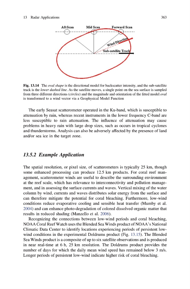
Fig. 13.14 The oval shape is the directional model for backscatter intensity, and the sub-satellite
track is the lower dashed line. As the satellite moves, a single point on the sea surface is sampled
from three different directions (circles) and the magnitude and orientation of the fitted model oval
is transformed to a wind vector via a Geophysical Model Function
13 Radar Applications
363
attenuation by rain, whereas recent instruments in the lower frequency C-band are
less susceptible to rain attenuation. The influence of attenuation may cause
problems in heavy rain with large drop sizes, such as occurs in tropical cyclones
and thunderstorms. Analysis can also be adversely affected by the presence of land
and/or sea ice in the target zone.
13.5.2 Example Application
The spatial resolution, or pixel size, of scatterometers is typically 25 km, though
some enhanced processing can produce 12.5 km products. For coral reef management, scatterometer winds are useful to describe the surrounding environment
at the reef scale, which has relevance to interconnectivity and pollution management, and in assessing the surface currents and waves. Vertical mixing of the water
column by wind, currents and waves distributes solar energy from the surface and
can therefore mitigate the potential for coral bleaching. Furthermore, low-wind
conditions reduce evaporative cooling and sensible heat transfer (Mumby et al.
2004) and can enhance photo-degradation of colored dissolved organic matter that
results in reduced shading (Manzello et al. 2006).
Recognizing the connections between low-wind periods and coral bleaching,
NOAA Coral Reef Watch uses the Blended Sea Winds product of NOAA’s National
Climatic Data Center to identify locations experiencing periods of persistent lowwind conditions in the experimental Doldrums product (Fig. 13.15). The Blended
Sea Winds product is a composite of up to six satellite observations and is produced
in near real-time at 6 h, 25 km resolution. The Doldrums product provides the
number of days for which the daily mean wind speed has remained below 3 m/s.
Longer periods of persistent low-wind indicate higher risk of coral bleaching.
Fig. 13.14 The oval shape is the directional model for backscatter intensity, and the sub-satellite
track is the lower dashed line. As the satellite moves, a single point on the sea surface is sampled
from three different directions (circles) and the magnitude and orientation of the fitted model oval
is transformed to a wind vector via a Geophysical Model Function
13 Radar Applications
363