

In contrast, the remaining infrared wavelengths (*2.5 lm to 1 mm) are emitted
by target bodies providing their own thermal signature. The second spectral region
for thermal remote sensing, the microwave, encompasses wavelengths from 1 mm
to 1 m (300 to 0.3 GHz). The advantages and disadvantages for measuring temperature remotely using each of these regions are discussed here.
Satellite sensors are used to remotely sense ocean temperature (and related
environmental parameters) around coral reefs, and typically observe bands of
electromagnetic radiation (channels) in the wavelength range 400 nm to 15.0 lm,
covering the visible and parts of the infrared spectrum. The specific spectral bands
within this range depend upon the instrument design, which in turn is prescribed
by the parameters desired for study (see Table 11.1 for examples). The effect of
the atmosphere on surface emissions is pertinent to the channel design and is
discussed in Sect. 11.2.2. Monitoring of temperature and other parameters (e.g.,
rainfall, wind speed, water vapor, cloud vapor, snow, ice and soil moisture) is also
conducted using combinations of microwave channels. For example, the Advanced
Microwave Scanning Radiometer for EOS (AMSR-E) instrument passively measures horizontally- and vertically-polarized signals in the frequency bands 6.925,
10.65, 18.7, 23.8, 36.5 and 89.0 GHz (wavelengths ranging from 43 mm down to
3 mm, respectively).
The satellite orbit characteristics impact the spatial and temporal resolution of
satellite data. Modern environmental satellites generally orbit in one of two
regimes: sun-synchronous and geosynchronous. Sun-synchronous satellites orbit in
an approximately North–South plane at relatively low altitude (*800 km), passing approximately over Earth’s poles multiple times each day to provide coverage
over most ocean locations twice-daily. These satellites cross the equator at the
same local time for each overpass. In contrast, geo-synchronous satellites are
designed to sit at high altitude (*36,000 km) above a single location near the
Earth’s equator, orbiting in an approximately East–West plane at the same rotational speed as the Earth. As such, there is a nearly constant but only partial
coverage of the Earth’s surface that a single geo-synchronous satellite can measure—but with the advantage of increased temporal resolution. It should be noted
that current and historical satellites have also had orbit regimes operating between
these North–South and East–West extremes (e.g., the International Space Station
Gamma
X-ray
UV
Visible
Infrared
Microwave
Radio
Frequency
Wavelength (m)
10
-12
10
-6
10
0
3 ×10
20
3 ×10
14
3 ×10
8
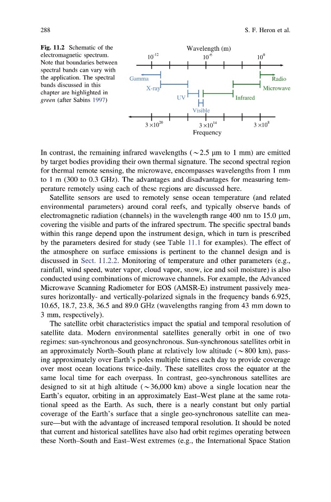
Fig. 11.2 Schematic of the
electromagnetic spectrum.
Note that boundaries between
spectral bands can vary with
the application. The spectral
bands discussed in this
chapter are highlighted in
green (after Sabins 1997)
288
S. F. Heron et al.
by target bodies providing their own thermal signature. The second spectral region
for thermal remote sensing, the microwave, encompasses wavelengths from 1 mm
to 1 m (300 to 0.3 GHz). The advantages and disadvantages for measuring temperature remotely using each of these regions are discussed here.
Satellite sensors are used to remotely sense ocean temperature (and related
environmental parameters) around coral reefs, and typically observe bands of
electromagnetic radiation (channels) in the wavelength range 400 nm to 15.0 lm,
covering the visible and parts of the infrared spectrum. The specific spectral bands
within this range depend upon the instrument design, which in turn is prescribed
by the parameters desired for study (see Table 11.1 for examples). The effect of
the atmosphere on surface emissions is pertinent to the channel design and is
discussed in Sect. 11.2.2. Monitoring of temperature and other parameters (e.g.,
rainfall, wind speed, water vapor, cloud vapor, snow, ice and soil moisture) is also
conducted using combinations of microwave channels. For example, the Advanced
Microwave Scanning Radiometer for EOS (AMSR-E) instrument passively measures horizontally- and vertically-polarized signals in the frequency bands 6.925,
10.65, 18.7, 23.8, 36.5 and 89.0 GHz (wavelengths ranging from 43 mm down to
3 mm, respectively).
The satellite orbit characteristics impact the spatial and temporal resolution of
satellite data. Modern environmental satellites generally orbit in one of two
regimes: sun-synchronous and geosynchronous. Sun-synchronous satellites orbit in
an approximately North–South plane at relatively low altitude (*800 km), passing approximately over Earth’s poles multiple times each day to provide coverage
over most ocean locations twice-daily. These satellites cross the equator at the
same local time for each overpass. In contrast, geo-synchronous satellites are
designed to sit at high altitude (*36,000 km) above a single location near the
Earth’s equator, orbiting in an approximately East–West plane at the same rotational speed as the Earth. As such, there is a nearly constant but only partial
coverage of the Earth’s surface that a single geo-synchronous satellite can measure—but with the advantage of increased temporal resolution. It should be noted
that current and historical satellites have also had orbit regimes operating between
these North–South and East–West extremes (e.g., the International Space Station
Gamma
X-ray
UV
Visible
Infrared
Microwave
Radio
Frequency
Wavelength (m)
10
-12
10
-6
10
0
3 ×10
20
3 ×10
14
3 ×10
8
Fig. 11.2 Schematic of the
electromagnetic spectrum.
Note that boundaries between
spectral bands can vary with
the application. The spectral
bands discussed in this
chapter are highlighted in
green (after Sabins 1997)
288
S. F. Heron et al.