

(i.e., after radiometric, geometric, and atmospheric corrections) to final classification. An example classification resulting from this technique using SHOALS
LiDAR and CASI-1500 hyperspectral imagery is shown in Fig. 7.9 for Hilo Bay, HI.
Chapter 3 discussed the utility of landcover classifications, in particular changes
in landcover, to help assess the impact of anthropogenic processes on nearby coral
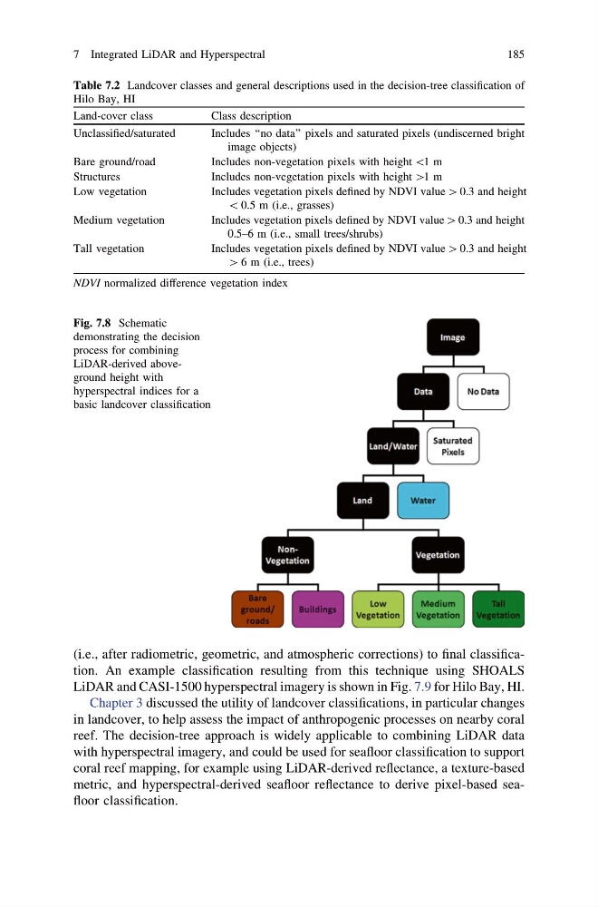
reef. The decision-tree approach is widely applicable to combining LiDAR data
with hyperspectral imagery, and could be used for seafloor classification to support
coral reef mapping, for example using LiDAR-derived reflectance, a texture-based
metric, and hyperspectral-derived seafloor reflectance to derive pixel-based seafloor classification.
Table 7.2 Landcover classes and general descriptions used in the decision-tree classification of
Hilo Bay, HI
Land-cover class
Class description
Unclassified/saturated
Includes ‘‘no data’’ pixels and saturated pixels (undiscerned bright
image objects)
Bare ground/road
Includes non-vegetation pixels with height \1 m
Structures
Includes non-vegetation pixels with height [1 m
Low vegetation
Includes vegetation pixels defined by NDVI value [ 0.3 and height
\ 0.5 m (i.e., grasses)
Medium vegetation
Includes vegetation pixels defined by NDVI value [ 0.3 and height
0.5–6 m (i.e., small trees/shrubs)
Tall vegetation
Includes vegetation pixels defined by NDVI value [ 0.3 and height
[ 6 m (i.e., trees)
NDVI normalized difference vegetation index
Fig. 7.8 Schematic
demonstrating the decision
process for combining
LiDAR-derived aboveground height with
hyperspectral indices for a
basic landcover classification
7 Integrated LiDAR and Hyperspectral
185
LiDAR and CASI-1500 hyperspectral imagery is shown in Fig. 7.9 for Hilo Bay, HI.
Chapter 3 discussed the utility of landcover classifications, in particular changes
in landcover, to help assess the impact of anthropogenic processes on nearby coral
reef. The decision-tree approach is widely applicable to combining LiDAR data
with hyperspectral imagery, and could be used for seafloor classification to support
coral reef mapping, for example using LiDAR-derived reflectance, a texture-based
metric, and hyperspectral-derived seafloor reflectance to derive pixel-based seafloor classification.
Table 7.2 Landcover classes and general descriptions used in the decision-tree classification of
Hilo Bay, HI
Land-cover class
Class description
Unclassified/saturated
Includes ‘‘no data’’ pixels and saturated pixels (undiscerned bright
image objects)
Bare ground/road
Includes non-vegetation pixels with height \1 m
Structures
Includes non-vegetation pixels with height [1 m
Low vegetation
Includes vegetation pixels defined by NDVI value [ 0.3 and height
\ 0.5 m (i.e., grasses)
Medium vegetation
Includes vegetation pixels defined by NDVI value [ 0.3 and height
0.5–6 m (i.e., small trees/shrubs)
Tall vegetation
Includes vegetation pixels defined by NDVI value [ 0.3 and height
[ 6 m (i.e., trees)
NDVI normalized difference vegetation index
Fig. 7.8 Schematic
demonstrating the decision
process for combining
LiDAR-derived aboveground height with
hyperspectral indices for a
basic landcover classification
7 Integrated LiDAR and Hyperspectral
185