

fusion techniques can contain rich levels of information at the pixel level. New
developments are underway to advance fusion in the spatial domain, so that
identification and classification occurs at the object level in the spatial domain
(i.e., processing groups of pixels rather than pixel-by-pixel methods). Current data
fusion methods for benthic mapping include techniques from all of the levels
identified in Table 7.1.
7.2.2 LiDAR-Derived Parameters
The first steps toward integrating LiDAR data with hyperspectral imagery are the
extraction of the various LiDAR-derived parameters, such as water depth, seafloor
reflectance, water column attenuation, water column volume reflectance, and water
Table 7.1 Example processing methods for the ‘Technique’ axis of the SIT data fusion model,
with increasing complexity from simple models to complex cognition approaches
Technique
Examples
Model
Simulation, estimation (least squares)
Extraction
Signal, pixel, segment
Inference
Parametric (clustering), non-parametric (neural nets)
Cognition
Templates, fuzzy set theory, knowledge systems (rules, Dempster-Shafer)
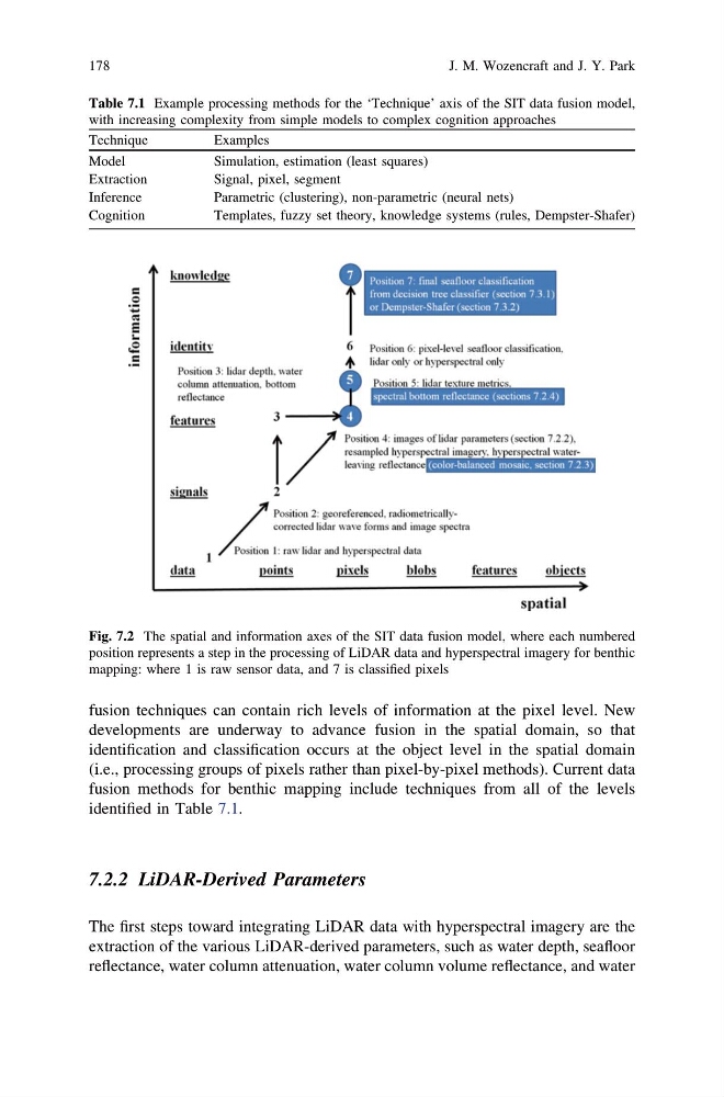
Fig. 7.2 The spatial and information axes of the SIT data fusion model, where each numbered
position represents a step in the processing of LiDAR data and hyperspectral imagery for benthic
mapping: where 1 is raw sensor data, and 7 is classified pixels
178
J. M. Wozencraft and J. Y. Park
developments are underway to advance fusion in the spatial domain, so that
identification and classification occurs at the object level in the spatial domain
(i.e., processing groups of pixels rather than pixel-by-pixel methods). Current data
fusion methods for benthic mapping include techniques from all of the levels
identified in Table 7.1.
7.2.2 LiDAR-Derived Parameters
The first steps toward integrating LiDAR data with hyperspectral imagery are the
extraction of the various LiDAR-derived parameters, such as water depth, seafloor
reflectance, water column attenuation, water column volume reflectance, and water
Table 7.1 Example processing methods for the ‘Technique’ axis of the SIT data fusion model,
with increasing complexity from simple models to complex cognition approaches
Technique
Examples
Model
Simulation, estimation (least squares)
Extraction
Signal, pixel, segment
Inference
Parametric (clustering), non-parametric (neural nets)
Cognition
Templates, fuzzy set theory, knowledge systems (rules, Dempster-Shafer)
Fig. 7.2 The spatial and information axes of the SIT data fusion model, where each numbered
position represents a step in the processing of LiDAR data and hyperspectral imagery for benthic
mapping: where 1 is raw sensor data, and 7 is classified pixels
178
J. M. Wozencraft and J. Y. Park