

6.2.4 Marine Protected Area Planning
Effective implementation of coastal and marine spatial planning (CMSP) relies on a
comprehensive geospatial framework. For example, planning units are typically
discrete geographic locations or zones that may have particular characteristics of
interest and are considered to be ‘place-based’ (Norse et al. 2005; Olsen et al.
2010). In the marine environment, marine protected areas (MPAs) are among the
most widely implemented forms of place-based management (Lorenzen et al.
2010). One of the critical first steps in CMSP involves mapping and integrating
biological and physical datasets (Douvere 2008; Pittman et al. 2011a). This method
has been successful in marine planning and spatial conservation prioritization
efforts worldwide (Sala et al. 2002; Friedlander et al. 2003; Jordan et al. 2005).
Presented here is an example of marine spatial planning in Hawaii, where
LiDAR technology was applied to assist in the spatial characterization of complex
habitats to inform marine conservation planning and evaluation. In the Main
Hawaiian Islands, SHOALS data was utilized to spatially characterize habitat
complexity across a broad range of nearshore coral reef ecosystems. An initial
pilot study was first conducted in Hanauma Bay Marine Life Conservation District
(MLCD) to determine the utility of LiDAR data to quantify complexity in a
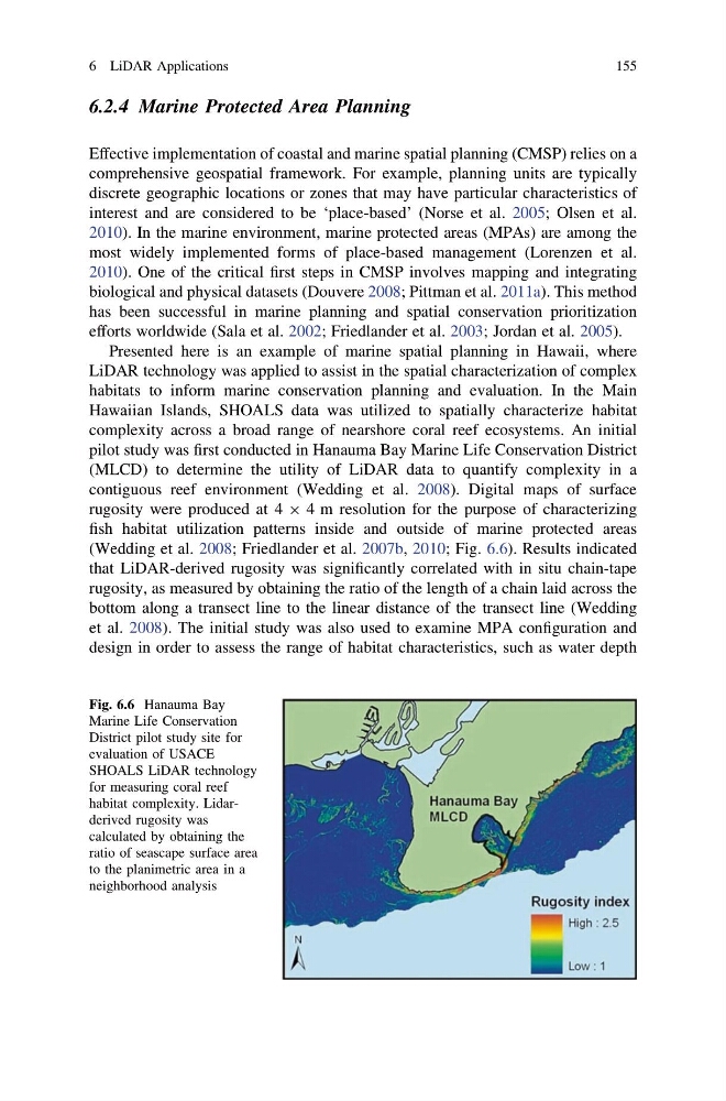
contiguous reef environment (Wedding et al. 2008). Digital maps of surface
rugosity were produced at 4 9 4 m resolution for the purpose of characterizing
fish habitat utilization patterns inside and outside of marine protected areas
(Wedding et al. 2008; Friedlander et al. 2007b, 2010; Fig. 6.6). Results indicated
that LiDAR-derived rugosity was significantly correlated with in situ chain-tape
rugosity, as measured by obtaining the ratio of the length of a chain laid across the
bottom along a transect line to the linear distance of the transect line (Wedding
et al. 2008). The initial study was also used to examine MPA configuration and
design in order to assess the range of habitat characteristics, such as water depth
Fig. 6.6 Hanauma Bay
Marine Life Conservation
District pilot study site for
evaluation of USACE
SHOALS LiDAR technology
for measuring coral reef
habitat complexity. Lidarderived rugosity was
calculated by obtaining the
ratio of seascape surface area
to the planimetric area in a
neighborhood analysis
6 LiDAR Applications
155
Effective implementation of coastal and marine spatial planning (CMSP) relies on a
comprehensive geospatial framework. For example, planning units are typically
discrete geographic locations or zones that may have particular characteristics of
interest and are considered to be ‘place-based’ (Norse et al. 2005; Olsen et al.
2010). In the marine environment, marine protected areas (MPAs) are among the
most widely implemented forms of place-based management (Lorenzen et al.
2010). One of the critical first steps in CMSP involves mapping and integrating
biological and physical datasets (Douvere 2008; Pittman et al. 2011a). This method
has been successful in marine planning and spatial conservation prioritization
efforts worldwide (Sala et al. 2002; Friedlander et al. 2003; Jordan et al. 2005).
Presented here is an example of marine spatial planning in Hawaii, where
LiDAR technology was applied to assist in the spatial characterization of complex
habitats to inform marine conservation planning and evaluation. In the Main
Hawaiian Islands, SHOALS data was utilized to spatially characterize habitat
complexity across a broad range of nearshore coral reef ecosystems. An initial
pilot study was first conducted in Hanauma Bay Marine Life Conservation District
(MLCD) to determine the utility of LiDAR data to quantify complexity in a
contiguous reef environment (Wedding et al. 2008). Digital maps of surface
rugosity were produced at 4 9 4 m resolution for the purpose of characterizing
fish habitat utilization patterns inside and outside of marine protected areas
(Wedding et al. 2008; Friedlander et al. 2007b, 2010; Fig. 6.6). Results indicated
that LiDAR-derived rugosity was significantly correlated with in situ chain-tape
rugosity, as measured by obtaining the ratio of the length of a chain laid across the
bottom along a transect line to the linear distance of the transect line (Wedding
et al. 2008). The initial study was also used to examine MPA configuration and
design in order to assess the range of habitat characteristics, such as water depth
Fig. 6.6 Hanauma Bay
Marine Life Conservation
District pilot study site for
evaluation of USACE
SHOALS LiDAR technology
for measuring coral reef
habitat complexity. Lidarderived rugosity was
calculated by obtaining the
ratio of seascape surface area
to the planimetric area in a
neighborhood analysis
6 LiDAR Applications
155