

measurements of water surface location with water level gauge measurements.
When coupled with robust GPS information, repeated postings within designated
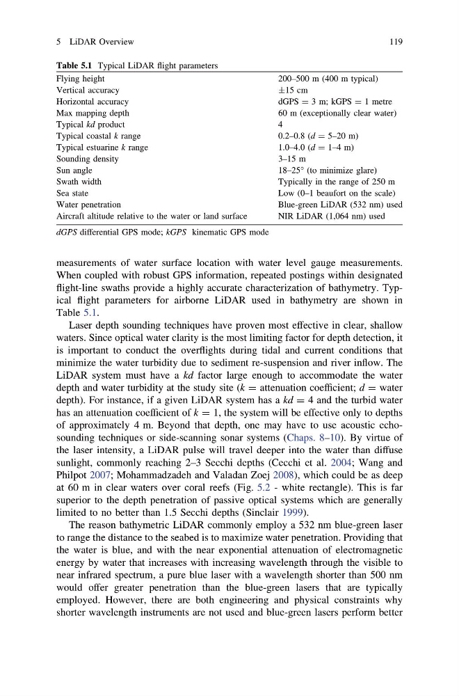
flight-line swaths provide a highly accurate characterization of bathymetry. Typical flight parameters for airborne LiDAR used in bathymetry are shown in
Table 5.1.
Laser depth sounding techniques have proven most effective in clear, shallow
waters. Since optical water clarity is the most limiting factor for depth detection, it
is important to conduct the overflights during tidal and current conditions that
minimize the water turbidity due to sediment re-suspension and river inflow. The
LiDAR system must have a kd factor large enough to accommodate the water
depth and water turbidity at the study site (k = attenuation coefficient; d = water
depth). For instance, if a given LiDAR system has a kd = 4 and the turbid water
has an attenuation coefficient of k = 1, the system will be effective only to depths
of approximately 4 m. Beyond that depth, one may have to use acoustic echosounding techniques or side-scanning sonar systems (Chaps. 8–10). By virtue of
the laser intensity, a LiDAR pulse will travel deeper into the water than diffuse
sunlight, commonly reaching 2–3 Secchi depths (Cecchi et al. 2004; Wang and
Philpot 2007; Mohammadzadeh and Valadan Zoej 2008), which could be as deep
at 60 m in clear waters over coral reefs (Fig. 5.2 - white rectangle). This is far
superior to the depth penetration of passive optical systems which are generally
limited to no better than 1.5 Secchi depths (Sinclair 1999).
The reason bathymetric LiDAR commonly employ a 532 nm blue-green laser
to range the distance to the seabed is to maximize water penetration. Providing that
the water is blue, and with the near exponential attenuation of electromagnetic
energy by water that increases with increasing wavelength through the visible to
near infrared spectrum, a pure blue laser with a wavelength shorter than 500 nm
would offer greater penetration than the blue-green lasers that are typically
employed. However, there are both engineering and physical constraints why
shorter wavelength instruments are not used and blue-green lasers perform better
Table 5.1 Typical LiDAR flight parameters
Flying height
200–500 m (400 m typical)
Vertical accuracy
±15 cm
Horizontal accuracy
dGPS = 3 m; kGPS = 1 metre
Max mapping depth
60 m (exceptionally clear water)
Typical kd product
4
Typical coastal k range
0.2–0.8 (d = 5–20 m)
Typical estuarine k range
1.0–4.0 (d = 1–4 m)
Sounding density
3–15 m
Sun angle
18–25° (to minimize glare)
Swath width
Typically in the range of 250 m
Sea state
Low (0–1 beaufort on the scale)
Water penetration
Blue-green LiDAR (532 nm) used
Aircraft altitude relative to the water or land surface
NIR LiDAR (1,064 nm) used
dGPS differential GPS mode; kGPS kinematic GPS mode
5 LiDAR Overview
119
When coupled with robust GPS information, repeated postings within designated
flight-line swaths provide a highly accurate characterization of bathymetry. Typical flight parameters for airborne LiDAR used in bathymetry are shown in
Table 5.1.
Laser depth sounding techniques have proven most effective in clear, shallow
waters. Since optical water clarity is the most limiting factor for depth detection, it
is important to conduct the overflights during tidal and current conditions that
minimize the water turbidity due to sediment re-suspension and river inflow. The
LiDAR system must have a kd factor large enough to accommodate the water
depth and water turbidity at the study site (k = attenuation coefficient; d = water
depth). For instance, if a given LiDAR system has a kd = 4 and the turbid water
has an attenuation coefficient of k = 1, the system will be effective only to depths
of approximately 4 m. Beyond that depth, one may have to use acoustic echosounding techniques or side-scanning sonar systems (Chaps. 8–10). By virtue of
the laser intensity, a LiDAR pulse will travel deeper into the water than diffuse
sunlight, commonly reaching 2–3 Secchi depths (Cecchi et al. 2004; Wang and
Philpot 2007; Mohammadzadeh and Valadan Zoej 2008), which could be as deep
at 60 m in clear waters over coral reefs (Fig. 5.2 - white rectangle). This is far
superior to the depth penetration of passive optical systems which are generally
limited to no better than 1.5 Secchi depths (Sinclair 1999).
The reason bathymetric LiDAR commonly employ a 532 nm blue-green laser
to range the distance to the seabed is to maximize water penetration. Providing that
the water is blue, and with the near exponential attenuation of electromagnetic
energy by water that increases with increasing wavelength through the visible to
near infrared spectrum, a pure blue laser with a wavelength shorter than 500 nm
would offer greater penetration than the blue-green lasers that are typically
employed. However, there are both engineering and physical constraints why
shorter wavelength instruments are not used and blue-green lasers perform better
Table 5.1 Typical LiDAR flight parameters
Flying height
200–500 m (400 m typical)
Vertical accuracy
±15 cm
Horizontal accuracy
dGPS = 3 m; kGPS = 1 metre
Max mapping depth
60 m (exceptionally clear water)
Typical kd product
4
Typical coastal k range
0.2–0.8 (d = 5–20 m)
Typical estuarine k range
1.0–4.0 (d = 1–4 m)
Sounding density
3–15 m
Sun angle
18–25° (to minimize glare)
Swath width
Typically in the range of 250 m
Sea state
Low (0–1 beaufort on the scale)
Water penetration
Blue-green LiDAR (532 nm) used
Aircraft altitude relative to the water or land surface
NIR LiDAR (1,064 nm) used
dGPS differential GPS mode; kGPS kinematic GPS mode
5 LiDAR Overview
119