

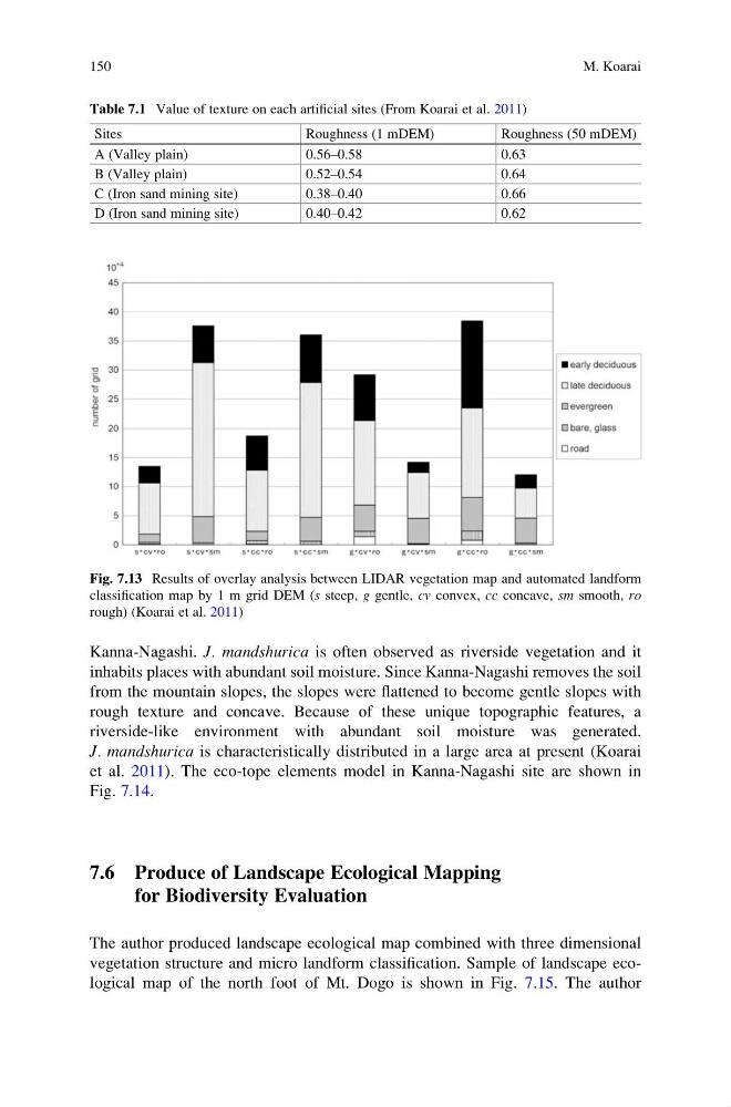
Kanna-Nagashi. J. mandshurica is often observed as riverside vegetation and it
inhabits places with abundant soil moisture. Since Kanna-Nagashi removes the soil
from the mountain slopes, the slopes were flattened to become gentle slopes with
rough texture and concave. Because of these unique topographic features, a
riverside-like environment with abundant soil moisture was generated.
J. mandshurica is characteristically distributed in a large area at present (Koarai
et al. 2011). The eco-tope elements model in Kanna-Nagashi site are shown in
Fig. 7.14.
7.6 Produce of Landscape Ecological Mapping
for Biodiversity Evaluation
The author produced landscape ecological map combined with three dimensional
vegetation structure and micro landform classification. Sample of landscape ecological map of the north foot of Mt. Dogo is shown in Fig. 7.15. The author
Table 7.1 Value of texture on each artificial sites (From Koarai et al. 2011)
Sites
Roughness (1 mDEM)
Roughness (50 mDEM)
A (Valley plain)
0.56–0.58
0.63
B (Valley plain)
0.52–0.54
0.64
C (Iron sand mining site)
0.38–0.40
0.66
D (Iron sand mining site)
0.40–0.42
0.62
Fig. 7.13 Results of overlay analysis between LIDAR vegetation map and automated landform
classification map by 1 m grid DEM (s steep, g gentle, cv convex, cc concave, sm smooth, ro
rough) (Koarai et al. 2011)
150
M. Koarai
inhabits places with abundant soil moisture. Since Kanna-Nagashi removes the soil
from the mountain slopes, the slopes were flattened to become gentle slopes with
rough texture and concave. Because of these unique topographic features, a
riverside-like environment with abundant soil moisture was generated.
J. mandshurica is characteristically distributed in a large area at present (Koarai
et al. 2011). The eco-tope elements model in Kanna-Nagashi site are shown in
Fig. 7.14.
7.6 Produce of Landscape Ecological Mapping
for Biodiversity Evaluation
The author produced landscape ecological map combined with three dimensional
vegetation structure and micro landform classification. Sample of landscape ecological map of the north foot of Mt. Dogo is shown in Fig. 7.15. The author
Table 7.1 Value of texture on each artificial sites (From Koarai et al. 2011)
Sites
Roughness (1 mDEM)
Roughness (50 mDEM)
A (Valley plain)
0.56–0.58
0.63
B (Valley plain)
0.52–0.54
0.64
C (Iron sand mining site)
0.38–0.40
0.66
D (Iron sand mining site)
0.40–0.42
0.62
Fig. 7.13 Results of overlay analysis between LIDAR vegetation map and automated landform
classification map by 1 m grid DEM (s steep, g gentle, cv convex, cc concave, sm smooth, ro
rough) (Koarai et al. 2011)
150
M. Koarai