

considered new type legend of landscape ecological map of studied area in this
research, using the results of overlay analysis of LIDAR vegetation maps and
automated landform classification maps. The legend of this map is matrix of three
dimensional vegetation map and automated landform classification map (Koarai
et al. 2012). He now plans to introduce the utilization method of landscape
ecological maps for natural environment conservation planning.
Since the Shiretoko Peninsula is the area currently afflicted by the vermin
damage of the deer, the thin crown thickness areas of the Shiretoko Peninsula can
be expected as the areas of a heavy vermin damage of a deer. In the Chugoku
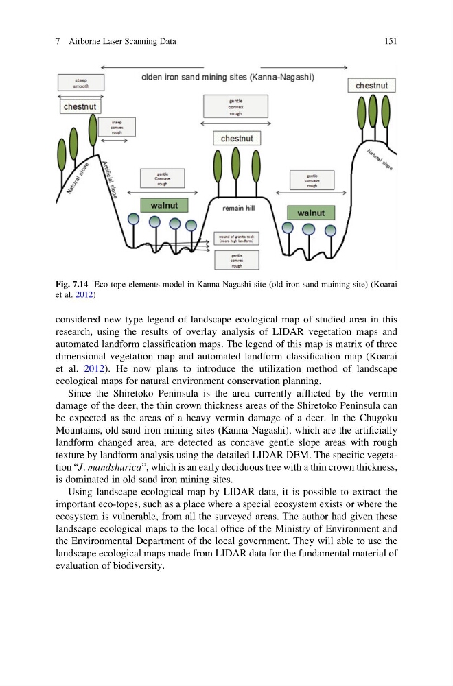
Mountains, old sand iron mining sites (Kanna-Nagashi), which are the artificially
landform changed area, are detected as concave gentle slope areas with rough
texture by landform analysis using the detailed LIDAR DEM. The specific vegetation “J. mandshurica”, which is an early deciduous tree with a thin crown thickness,
is dominated in old sand iron mining sites.
Using landscape ecological map by LIDAR data, it is possible to extract the
important eco-topes, such as a place where a special ecosystem exists or where the
ecosystem is vulnerable, from all the surveyed areas. The author had given these
landscape ecological maps to the local office of the Ministry of Environment and
the Environmental Department of the local government. They will able to use the
landscape ecological maps made from LIDAR data for the fundamental material of
evaluation of biodiversity.
Fig. 7.14 Eco-tope elements model in Kanna-Nagashi site (old iron sand maining site) (Koarai
et al. 2012)
7 Airborne Laser Scanning Data
151
research, using the results of overlay analysis of LIDAR vegetation maps and
automated landform classification maps. The legend of this map is matrix of three
dimensional vegetation map and automated landform classification map (Koarai
et al. 2012). He now plans to introduce the utilization method of landscape
ecological maps for natural environment conservation planning.
Since the Shiretoko Peninsula is the area currently afflicted by the vermin
damage of the deer, the thin crown thickness areas of the Shiretoko Peninsula can
be expected as the areas of a heavy vermin damage of a deer. In the Chugoku
Mountains, old sand iron mining sites (Kanna-Nagashi), which are the artificially
landform changed area, are detected as concave gentle slope areas with rough
texture by landform analysis using the detailed LIDAR DEM. The specific vegetation “J. mandshurica”, which is an early deciduous tree with a thin crown thickness,
is dominated in old sand iron mining sites.
Using landscape ecological map by LIDAR data, it is possible to extract the
important eco-topes, such as a place where a special ecosystem exists or where the
ecosystem is vulnerable, from all the surveyed areas. The author had given these
landscape ecological maps to the local office of the Ministry of Environment and
the Environmental Department of the local government. They will able to use the
landscape ecological maps made from LIDAR data for the fundamental material of
evaluation of biodiversity.
Fig. 7.14 Eco-tope elements model in Kanna-Nagashi site (old iron sand maining site) (Koarai
et al. 2012)
7 Airborne Laser Scanning Data
151