

85
The approach of using variables instead of predefined classes enables the program
to conform by conversion into other classifications, both nationally and internationally, including the European Environment Agency EUNIS habitat type classification
(Davies et al. 2004), the Food and Agriculture Organisation (FAO) Land Cover
Classification system, LCCS (Di Gregorio and Janssen 2005). The harmonization
effort of the European Biodiversity Observation Network (EBONE), represents the
first work with conversion of the NILS remote sensing data (Ortega et al. 2012;
Allard 2012a). A presentation of the national NILS remote sensing data, in the land
use classification system of the governmental authority Statistics Sweden, is given in
Fig. 4. The data is from the first rotation, 2003–2007 and compares well to the official data from 2005, as is shown on the NILS on-line data portal (NILS 2017b).
Sweden is dominated by forest, wetland and mountainous areas, although almost all
forests are actively managed, with rotations of clear-cuts and plantations of new saplings, and should not be considered as “natural land”. This classification uses a concept of forests as areas covered densely by trees, a closed canopy. Since then,
Statistics Sweden has adopted the classification system of the FAO, where forest is
most often classified as a 10% cover of trees (and a potential of reaching 5 m in
height), and no obvious other land use. Using the FAO classification Sweden has a
cover of “forest” reaching 79% (Statistics Sweden 2013).
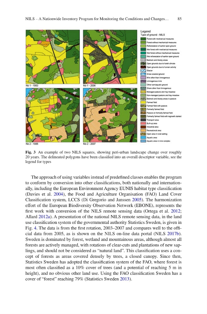
Fig. 3 An example of two NILS squares, showing peri-urban landscape change over roughly
20 years. The delineated polygons have been classified into an overall descriptor variable, see the
legend for types
NILS – A Nationwide Inventory Program for Monitoring the Conditions and Changes…
The approach of using variables instead of predefined classes enables the program
to conform by conversion into other classifications, both nationally and internationally, including the European Environment Agency EUNIS habitat type classification
(Davies et al. 2004), the Food and Agriculture Organisation (FAO) Land Cover
Classification system, LCCS (Di Gregorio and Janssen 2005). The harmonization
effort of the European Biodiversity Observation Network (EBONE), represents the
first work with conversion of the NILS remote sensing data (Ortega et al. 2012;
Allard 2012a). A presentation of the national NILS remote sensing data, in the land
use classification system of the governmental authority Statistics Sweden, is given in
Fig. 4. The data is from the first rotation, 2003–2007 and compares well to the official data from 2005, as is shown on the NILS on-line data portal (NILS 2017b).
Sweden is dominated by forest, wetland and mountainous areas, although almost all
forests are actively managed, with rotations of clear-cuts and plantations of new saplings, and should not be considered as “natural land”. This classification uses a concept of forests as areas covered densely by trees, a closed canopy. Since then,
Statistics Sweden has adopted the classification system of the FAO, where forest is
most often classified as a 10% cover of trees (and a potential of reaching 5 m in
height), and no obvious other land use. Using the FAO classification Sweden has a
cover of “forest” reaching 79% (Statistics Sweden 2013).
Fig. 3 An example of two NILS squares, showing peri-urban landscape change over roughly
20 years. The delineated polygons have been classified into an overall descriptor variable, see the
legend for types
NILS – A Nationwide Inventory Program for Monitoring the Conditions and Changes…