

86
For the data to be consistent across Sweden, the ancillary digital data covers
should also be consistent. That is seldom possible over a large country, so controlled
deviations are allowed in some cases: for example, LIDAR data and National
Reference maps are registered at lower resolution over the Mountains parts. During
the run of the program, research has been undertaken on several occasions to provide reliable data at low cost over the landscape square, mostly as hybrid methods,
using different digital layers of national data together with complementary interpretation of the stereo imagery. Updates to the classification procedures, including calibration and validation, are provided in Lindgren et al. (2015). A new digital terrain
model has also been integrated to produce wetness indices that cover most water
courses, including those within forests (Lestander et al. 2015). Many of the smaller
water courses in mountainous areas are also included in the mapping.
The NILS program is also looking forward and maximising the use of data from
the new European Sentinel-2 optical sensors, which became available from 2015.
As providers of data to others, SLU is currently collaborating with Metria in
Stockholm, to design a new scheme for collecting reference data (for training
classification algorithms as well as validation of the product) for the new National
Land Cover Data of Sweden: a continuation of a project called CadasterENV,
0%
10%
20%
30%
40%
50%
60%
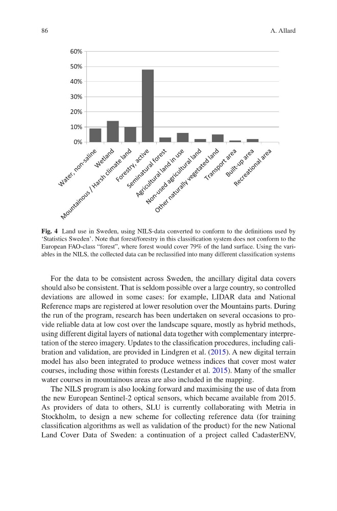
Fig. 4 Land use in Sweden, using NILS-data converted to conform to the definitions used by
‘Statistics Sweden’. Note that forest/forestry in this classification system does not conform to the
European FAO-class “forest”, where forest would cover 79% of the land surface. Using the variables in the NILS, the collected data can be reclassified into many different classification systems
A. Allard
For the data to be consistent across Sweden, the ancillary digital data covers
should also be consistent. That is seldom possible over a large country, so controlled
deviations are allowed in some cases: for example, LIDAR data and National
Reference maps are registered at lower resolution over the Mountains parts. During
the run of the program, research has been undertaken on several occasions to provide reliable data at low cost over the landscape square, mostly as hybrid methods,
using different digital layers of national data together with complementary interpretation of the stereo imagery. Updates to the classification procedures, including calibration and validation, are provided in Lindgren et al. (2015). A new digital terrain
model has also been integrated to produce wetness indices that cover most water
courses, including those within forests (Lestander et al. 2015). Many of the smaller
water courses in mountainous areas are also included in the mapping.
The NILS program is also looking forward and maximising the use of data from
the new European Sentinel-2 optical sensors, which became available from 2015.
As providers of data to others, SLU is currently collaborating with Metria in
Stockholm, to design a new scheme for collecting reference data (for training
classification algorithms as well as validation of the product) for the new National
Land Cover Data of Sweden: a continuation of a project called CadasterENV,
0%
10%
20%
30%
40%
50%
60%
Fig. 4 Land use in Sweden, using NILS-data converted to conform to the definitions used by
‘Statistics Sweden’. Note that forest/forestry in this classification system does not conform to the
European FAO-class “forest”, where forest would cover 79% of the land surface. Using the variables in the NILS, the collected data can be reclassified into many different classification systems
A. Allard