

239
Distributions of Tigers in Relation to Fires and Anthropogenic
Disturbance
The Manas NP section of the IBMTCL landscape experienced repeated and extensive burning between 2000 and 2012, with 1749 fire events recorded in the MOD 14
product. The greatest number of fires was in 2011, with 271 recorded (Fig. 6a). In
all years, there was considerable intra-annual variability, with the period December
to March associated with the highest frequency of fires. The transition period before
and after the monsoon season (May to September) (i.e., the first and last 2 months
of the dry season) experienced fewer fires. Manas NP is divided into three ranges;
the western range (Panbari), central (Bansbari) and eastern (Bhuyanpara), and the
density of fires (5.13 km
−2
) was greatest in the grassland areas of the Bansbari range,
with those in the Kuribeel and Pahu field areas repeatedly burnt. The incidence of
fires was greatest in the more open moist mixed deciduous forests (Fig. 6b; Table 8),
with this attributed largely to human activities. Over the period of the camera trapping, 32 fires were detected in the areas within which camera traps were placed.
Reference to the tiger data indicated that the highest number of counts (indicating
presence) was at a distance of 5–10 km from fires and often around the margins of
burnt areas (Fig. 7). In general, tigers were recorded away from roads and village
settlements, with this indicating their sensitivity to human activity, including vehicular movements.
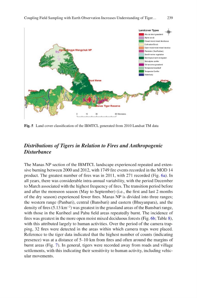
Fig. 5 Land cover classification of the IBMTCL generated from 2010 Landsat TM data
Coupling Field Sampling with Earth Observation Increases Understanding of Tiger…
Distributions of Tigers in Relation to Fires and Anthropogenic
Disturbance
The Manas NP section of the IBMTCL landscape experienced repeated and extensive burning between 2000 and 2012, with 1749 fire events recorded in the MOD 14
product. The greatest number of fires was in 2011, with 271 recorded (Fig. 6a). In
all years, there was considerable intra-annual variability, with the period December
to March associated with the highest frequency of fires. The transition period before
and after the monsoon season (May to September) (i.e., the first and last 2 months
of the dry season) experienced fewer fires. Manas NP is divided into three ranges;
the western range (Panbari), central (Bansbari) and eastern (Bhuyanpara), and the
density of fires (5.13 km
−2
) was greatest in the grassland areas of the Bansbari range,
with those in the Kuribeel and Pahu field areas repeatedly burnt. The incidence of
fires was greatest in the more open moist mixed deciduous forests (Fig. 6b; Table 8),
with this attributed largely to human activities. Over the period of the camera trapping, 32 fires were detected in the areas within which camera traps were placed.
Reference to the tiger data indicated that the highest number of counts (indicating
presence) was at a distance of 5–10 km from fires and often around the margins of
burnt areas (Fig. 7). In general, tigers were recorded away from roads and village
settlements, with this indicating their sensitivity to human activity, including vehicular movements.
Fig. 5 Land cover classification of the IBMTCL generated from 2010 Landsat TM data
Coupling Field Sampling with Earth Observation Increases Understanding of Tiger…