

235
Carnivore Distribution in Relation to Anthropogenic
Disturbance
Fires, roads and settlements were considered to be the main anthropogenic disturbances likely to influence the distribution and movement of large cats within the
landscape. The point distances tool available in the ArcGIS Geospatial Modelling
Environment (GSM; http://www.spatialecology.com/gme and previously known as
Hawths tools) was used to calculate the distances from tiger observations to fire
locations over the observation period. This tool, which was designed to produce
flexible distance matrix outputs, calculates distances between points. The output of
distance between each fire location and species capture point was then categorized
into 500 m intervals and analyzed using simple regression analysis. The null hypothesis that there was no link between fire and carnivore occurrence was rejected where
p > 0.05.
Results
Camera Trap Sightings
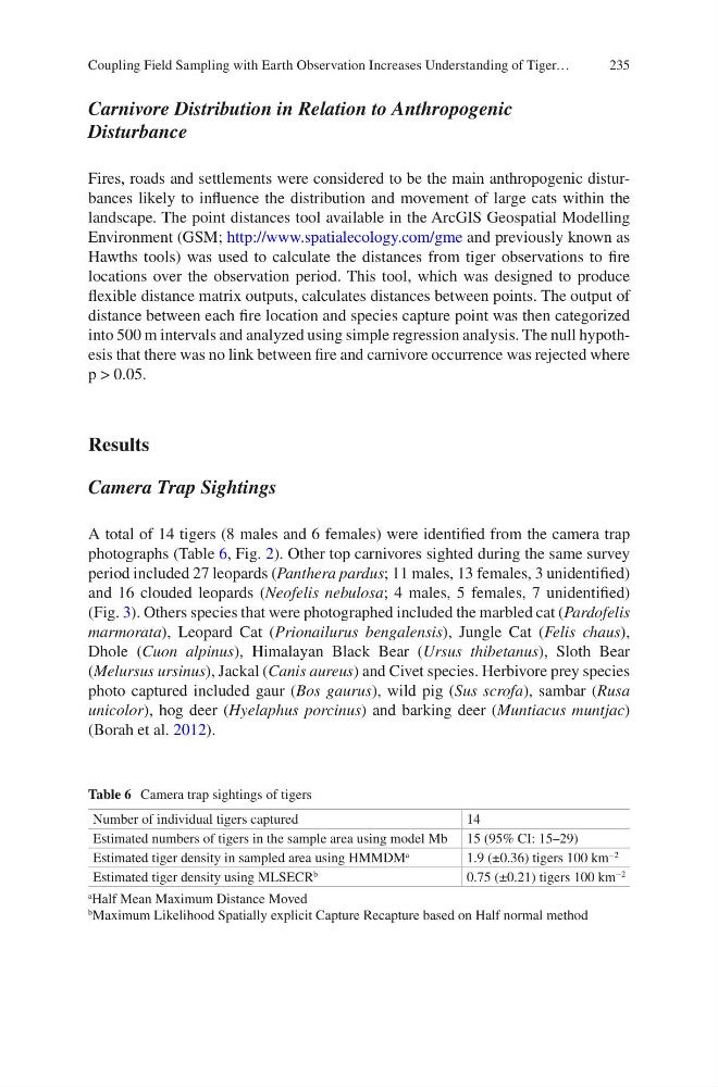
A total of 14 tigers (8 males and 6 females) were identified from the camera trap
photographs (Table 6, Fig. 2). Other top carnivores sighted during the same survey
period included 27 leopards (Panthera pardus; 11 males, 13 females, 3 unidentified)
and 16 clouded leopards (Neofelis nebulosa; 4 males, 5 females, 7 unidentified)
(Fig. 3). Others species that were photographed included the marbled cat (Pardofelis
marmorata), Leopard Cat (Prionailurus bengalensis), Jungle Cat (Felis chaus),
Dhole (Cuon alpinus), Himalayan Black Bear (Ursus thibetanus), Sloth Bear
(Melursus ursinus), Jackal (Canis aureus) and Civet species. Herbivore prey species
photo captured included gaur (Bos gaurus), wild pig (Sus scrofa), sambar (Rusa
unicolor), hog deer (Hyelaphus porcinus) and barking deer (Muntiacus muntjac)
(Borah et al. 2012).
Table 6 Camera trap sightings of tigers
Number of individual tigers captured
14
Estimated numbers of tigers in the sample area using model Mb 15 (95% CI: 15–29)
Estimated tiger density in sampled area using HMMDM
a
1.9 (±0.36) tigers 100 km
−2
Estimated tiger density using MLSECR
b
0.75 (±0.21) tigers 100 km
−2
a Half Mean Maximum Distance Moved
b
Maximum Likelihood Spatially explicit Capture Recapture based on Half normal method
Coupling Field Sampling with Earth Observation Increases Understanding of Tiger…
Carnivore Distribution in Relation to Anthropogenic
Disturbance
Fires, roads and settlements were considered to be the main anthropogenic disturbances likely to influence the distribution and movement of large cats within the
landscape. The point distances tool available in the ArcGIS Geospatial Modelling
Environment (GSM; http://www.spatialecology.com/gme and previously known as
Hawths tools) was used to calculate the distances from tiger observations to fire
locations over the observation period. This tool, which was designed to produce
flexible distance matrix outputs, calculates distances between points. The output of
distance between each fire location and species capture point was then categorized
into 500 m intervals and analyzed using simple regression analysis. The null hypothesis that there was no link between fire and carnivore occurrence was rejected where
p > 0.05.
Results
Camera Trap Sightings
A total of 14 tigers (8 males and 6 females) were identified from the camera trap
photographs (Table 6, Fig. 2). Other top carnivores sighted during the same survey
period included 27 leopards (Panthera pardus; 11 males, 13 females, 3 unidentified)
and 16 clouded leopards (Neofelis nebulosa; 4 males, 5 females, 7 unidentified)
(Fig. 3). Others species that were photographed included the marbled cat (Pardofelis
marmorata), Leopard Cat (Prionailurus bengalensis), Jungle Cat (Felis chaus),
Dhole (Cuon alpinus), Himalayan Black Bear (Ursus thibetanus), Sloth Bear
(Melursus ursinus), Jackal (Canis aureus) and Civet species. Herbivore prey species
photo captured included gaur (Bos gaurus), wild pig (Sus scrofa), sambar (Rusa
unicolor), hog deer (Hyelaphus porcinus) and barking deer (Muntiacus muntjac)
(Borah et al. 2012).
Table 6 Camera trap sightings of tigers
Number of individual tigers captured
14
Estimated numbers of tigers in the sample area using model Mb 15 (95% CI: 15–29)
Estimated tiger density in sampled area using HMMDM
a
1.9 (±0.36) tigers 100 km
−2
Estimated tiger density using MLSECR
b
0.75 (±0.21) tigers 100 km
−2
a Half Mean Maximum Distance Moved
b
Maximum Likelihood Spatially explicit Capture Recapture based on Half normal method
Coupling Field Sampling with Earth Observation Increases Understanding of Tiger…