

11 Information Hiding for Spatial and Geographical Data
241
In the following, we illustrate two possible scenarios where watermarking is applied to digital mapping: map copyright protection and map fingerprinting. In both
situations, we adopt the concept of third-party architecture that has been explored in
Chap. 10. However, we distinguish the publisher as two different entities that play an
important role in the GIS field: the map producer and the mapping services provider.
Map Copyright Protection. As a solution for copyright protection, watermarking
can be employed for assessing the digital rights on maps. People that benefit from
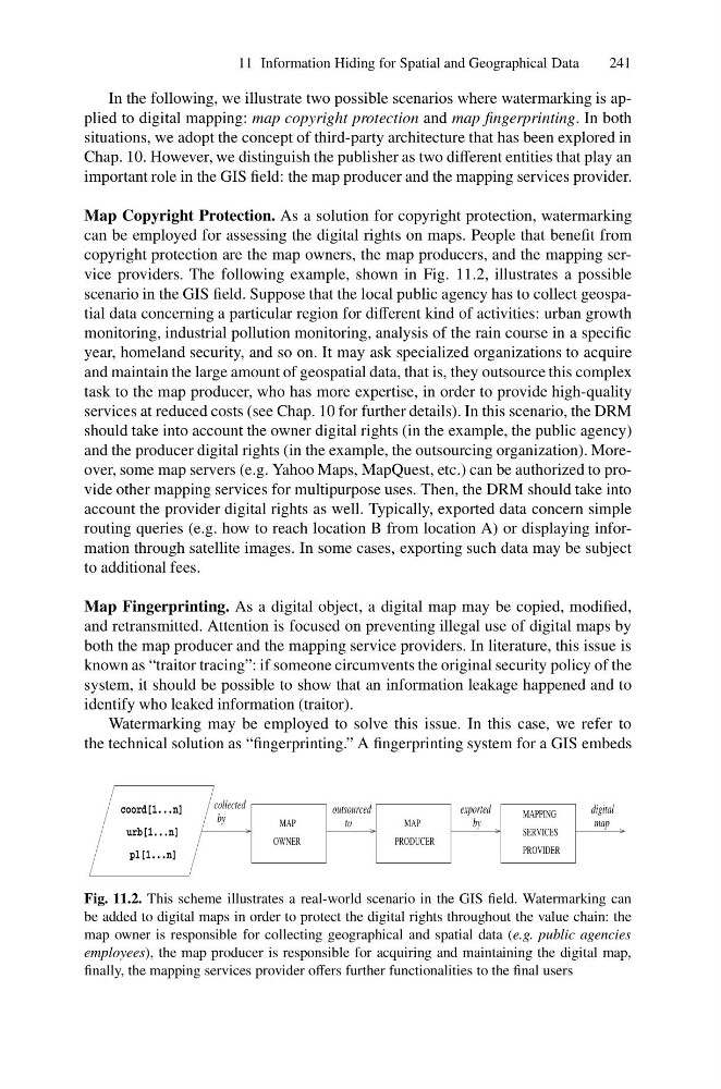
copyright protection are the map owners, the map producers, and the mapping service providers. The following example, shown in Fig. 11.2, illustrates a possible
scenario in the GIS field. Suppose that the local public agency has to collect geospatial data concerning a particular region for different kind of activities: urban growth
monitoring, industrial pollution monitoring, analysis of the rain course in a specific
year, homeland security, and so on. It may ask specialized organizations to acquire
and maintain the large amount of geospatial data, that is, they outsource this complex
task to the map producer, who has more expertise, in order to provide high-quality
services at reduced costs (see Chap. 10 for further details). In this scenario, the DRM
should take into account the owner digital rights (in the example, the public agency)
and the producer digital rights (in the example, the outsourcing organization). Moreover, some map servers (e.g. Yahoo Maps, MapQuest, etc.) can be authorized to provide other mapping services for multipurpose uses. Then, the DRM should take into
account the provider digital rights as well. Typically, exported data concern simple
routing queries (e.g. how to reach location B from location A) or displaying information through satellite images. In some cases, exporting such data may be subject
to additional fees.
Map Fingerprinting. As a digital object, a digital map may be copied, modified,
and retransmitted. Attention is focused on preventing illegal use of digital maps by
both the map producer and the mapping service providers. In literature, this issue is
known as “traitor tracing”: if someone circumvents the original security policy of the
system, it should be possible to show that an information leakage happened and to
identify who leaked information (traitor).
Watermarking may be employed to solve this issue. In this case, we refer to
the technical solution as “fingerprinting.” A fingerprinting system for a GIS embeds
OWNER
by
by
to
exported
urb[1...n]
coord[1...n]
pl[1...n]
collected
outsourced
map
digital
PRODUCER
MAP
MAPPING
SERVICES
PROVIDER
MAP
Fig. 11.2. This scheme illustrates a real-world scenario in the GIS field. Watermarking can
be added to digital maps in order to protect the digital rights throughout the value chain: the
map owner is responsible for collecting geographical and spatial data (e.g. public agencies
employees), the map producer is responsible for acquiring and maintaining the digital map,
finally, the mapping services provider offers further functionalities to the final users
241
In the following, we illustrate two possible scenarios where watermarking is applied to digital mapping: map copyright protection and map fingerprinting. In both
situations, we adopt the concept of third-party architecture that has been explored in
Chap. 10. However, we distinguish the publisher as two different entities that play an
important role in the GIS field: the map producer and the mapping services provider.
Map Copyright Protection. As a solution for copyright protection, watermarking
can be employed for assessing the digital rights on maps. People that benefit from
copyright protection are the map owners, the map producers, and the mapping service providers. The following example, shown in Fig. 11.2, illustrates a possible
scenario in the GIS field. Suppose that the local public agency has to collect geospatial data concerning a particular region for different kind of activities: urban growth
monitoring, industrial pollution monitoring, analysis of the rain course in a specific
year, homeland security, and so on. It may ask specialized organizations to acquire
and maintain the large amount of geospatial data, that is, they outsource this complex
task to the map producer, who has more expertise, in order to provide high-quality
services at reduced costs (see Chap. 10 for further details). In this scenario, the DRM
should take into account the owner digital rights (in the example, the public agency)
and the producer digital rights (in the example, the outsourcing organization). Moreover, some map servers (e.g. Yahoo Maps, MapQuest, etc.) can be authorized to provide other mapping services for multipurpose uses. Then, the DRM should take into
account the provider digital rights as well. Typically, exported data concern simple
routing queries (e.g. how to reach location B from location A) or displaying information through satellite images. In some cases, exporting such data may be subject
to additional fees.
Map Fingerprinting. As a digital object, a digital map may be copied, modified,
and retransmitted. Attention is focused on preventing illegal use of digital maps by
both the map producer and the mapping service providers. In literature, this issue is
known as “traitor tracing”: if someone circumvents the original security policy of the
system, it should be possible to show that an information leakage happened and to
identify who leaked information (traitor).
Watermarking may be employed to solve this issue. In this case, we refer to
the technical solution as “fingerprinting.” A fingerprinting system for a GIS embeds
OWNER
by
by
to
exported
urb[1...n]
coord[1...n]
pl[1...n]
collected
outsourced
map
digital
PRODUCER
MAP
MAPPING
SERVICES
PROVIDER
MAP
Fig. 11.2. This scheme illustrates a real-world scenario in the GIS field. Watermarking can
be added to digital maps in order to protect the digital rights throughout the value chain: the
map owner is responsible for collecting geographical and spatial data (e.g. public agencies
employees), the map producer is responsible for acquiring and maintaining the digital map,
finally, the mapping services provider offers further functionalities to the final users