

242
Maria Calagna and Luigi V. Mancini
a code into each delivered map. This code identifies the receivers univocally such
that if one of them circumvents the system, it is possible to identify who leaked
information by monitoring the delivered maps and tracing the fingerprinting code
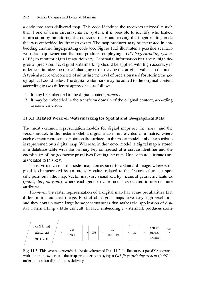
that was embedded by the map owner. The map producer may be interested in embedding another fingerprinting code too. Figure 11.3 illustrates a possible scenario
with the map owner and the map producer employing a GIS fingerprinting system
(GFS) to monitor digital maps delivery. Geospatial information has a very high degree of precision. So, digital watermarking should be applied with high accuracy in
order to minimize the risk of changing or destroying the original values in the map.
A typical approach consists of adjusting the level of precision used for storing the geographical coordinates. The digital watermark may be added to the original content
according to two different approaches, as follows:
1. It may be embedded to the digital content, directly.
2. It may be embedded in the transform domain of the original content, according
to some criterion.
11.3.1 Related Work on Watermarking for Spatial and Geographical Data
The most common representation models for digital maps are the raster and the
vector model. In the raster model, a digital map is represented as a matrix, where
each element represents a point on the surface. In the raster model, only one attribute
is represented by a digital map. Whereas, in the vector model, a digital map is stored
in a database table with the primary key composed of a unique identifier and the
coordinates of the geometric primitives forming the map. One or more attributes are
associated to this key.
Thus, visualization of a raster map corresponds to a standard image, where each
pixel is characterized by an intensity value, related to the feature value at a specific position in the map. Vector maps are visualized by means of geometric features
(point, line, polygon), where each geometric feature is associated to one or more
attributes.
However, the raster representation of a digital map has some peculiarities that
differ from a standard image. First of all, digital maps have very high resolution
and they contain some large homogeneous areas that makes the application of digital watermarking a little difficult. In fact, embedding a watermark produces some
PROVIDER
coord[1...n]
urb[1...n]
pl[1...n]
map
OWNER
GFS
MAP
MAP
PRODUCER
GFS
MAPPING
SERVICES
Fig. 11.3. This scheme extends the basic scheme of Fig. 11.2. It illustrates a possible scenario
with the map owner and the map producer employing a GIS fingerprinting system (GFS) in
order to monitor digital maps delivery
Maria Calagna and Luigi V. Mancini
a code into each delivered map. This code identifies the receivers univocally such
that if one of them circumvents the system, it is possible to identify who leaked
information by monitoring the delivered maps and tracing the fingerprinting code
that was embedded by the map owner. The map producer may be interested in embedding another fingerprinting code too. Figure 11.3 illustrates a possible scenario
with the map owner and the map producer employing a GIS fingerprinting system
(GFS) to monitor digital maps delivery. Geospatial information has a very high degree of precision. So, digital watermarking should be applied with high accuracy in
order to minimize the risk of changing or destroying the original values in the map.
A typical approach consists of adjusting the level of precision used for storing the geographical coordinates. The digital watermark may be added to the original content
according to two different approaches, as follows:
1. It may be embedded to the digital content, directly.
2. It may be embedded in the transform domain of the original content, according
to some criterion.
11.3.1 Related Work on Watermarking for Spatial and Geographical Data
The most common representation models for digital maps are the raster and the
vector model. In the raster model, a digital map is represented as a matrix, where
each element represents a point on the surface. In the raster model, only one attribute
is represented by a digital map. Whereas, in the vector model, a digital map is stored
in a database table with the primary key composed of a unique identifier and the
coordinates of the geometric primitives forming the map. One or more attributes are
associated to this key.
Thus, visualization of a raster map corresponds to a standard image, where each
pixel is characterized by an intensity value, related to the feature value at a specific position in the map. Vector maps are visualized by means of geometric features
(point, line, polygon), where each geometric feature is associated to one or more
attributes.
However, the raster representation of a digital map has some peculiarities that
differ from a standard image. First of all, digital maps have very high resolution
and they contain some large homogeneous areas that makes the application of digital watermarking a little difficult. In fact, embedding a watermark produces some
PROVIDER
coord[1...n]
urb[1...n]
pl[1...n]
map
OWNER
GFS
MAP
MAP
PRODUCER
GFS
MAPPING
SERVICES
Fig. 11.3. This scheme extends the basic scheme of Fig. 11.2. It illustrates a possible scenario
with the map owner and the map producer employing a GIS fingerprinting system (GFS) in
order to monitor digital maps delivery