

396
M. Ahmed and V. Barale
Fig. 19.13 Changes in western and eastern Boughaze of Lake Bardawil, as observed in 1993–2000
Landsat TM data. The “change detection” algorithm shows erosion in black and major accretion
areas (centered over the crossing red lines) in white
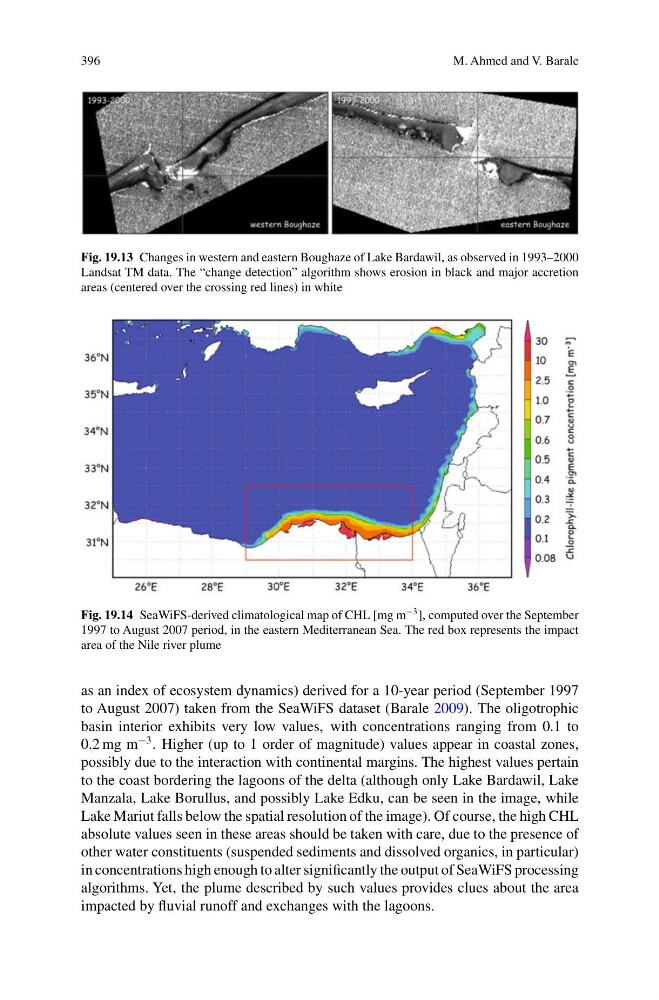
Fig. 19.14 SeaWiFS-derived climatological map of CHL [mg m
−3 ], computed over the September
1997 to August 2007 period, in the eastern Mediterranean Sea. The red box represents the impact
area of the Nile river plume
as an index of ecosystem dynamics) derived for a 10-year period (September 1997
to August 2007) taken from the SeaWiFS dataset (Barale 2009). The oligotrophic
basin interior exhibits very low values, with concentrations ranging from 0.1 to
0.2 mg m
−3 . Higher (up to 1 order of magnitude) values appear in coastal zones,
possibly due to the interaction with continental margins. The highest values pertain
to the coast bordering the lagoons of the delta (although only Lake Bardawil, Lake
Manzala, Lake Borullus, and possibly Lake Edku, can be seen in the image, while
Lake Mariut falls below the spatial resolution of the image). Of course, the high CHL
absolute values seen in these areas should be taken with care, due to the presence of
other water constituents (suspended sediments and dissolved organics, in particular)
in concentrations high enough to alter significantly the output of SeaWiFS processing
algorithms. Yet, the plume described by such values provides clues about the area
impacted by fluvial runoff and exchanges with the lagoons.
M. Ahmed and V. Barale
Fig. 19.13 Changes in western and eastern Boughaze of Lake Bardawil, as observed in 1993–2000
Landsat TM data. The “change detection” algorithm shows erosion in black and major accretion
areas (centered over the crossing red lines) in white
Fig. 19.14 SeaWiFS-derived climatological map of CHL [mg m
−3 ], computed over the September
1997 to August 2007 period, in the eastern Mediterranean Sea. The red box represents the impact
area of the Nile river plume
as an index of ecosystem dynamics) derived for a 10-year period (September 1997
to August 2007) taken from the SeaWiFS dataset (Barale 2009). The oligotrophic
basin interior exhibits very low values, with concentrations ranging from 0.1 to
0.2 mg m
−3 . Higher (up to 1 order of magnitude) values appear in coastal zones,
possibly due to the interaction with continental margins. The highest values pertain
to the coast bordering the lagoons of the delta (although only Lake Bardawil, Lake
Manzala, Lake Borullus, and possibly Lake Edku, can be seen in the image, while
Lake Mariut falls below the spatial resolution of the image). Of course, the high CHL
absolute values seen in these areas should be taken with care, due to the presence of
other water constituents (suspended sediments and dissolved organics, in particular)
in concentrations high enough to alter significantly the output of SeaWiFS processing
algorithms. Yet, the plume described by such values provides clues about the area
impacted by fluvial runoff and exchanges with the lagoons.