

394
M. Ahmed and V. Barale
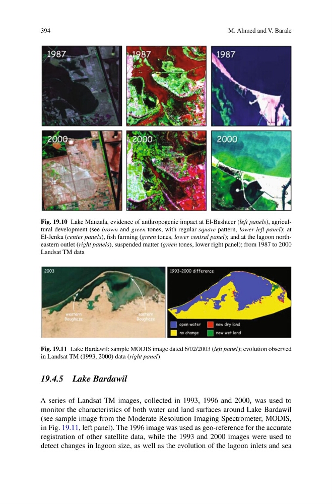
Fig. 19.10 Lake Manzala, evidence of anthropogenic impact at El-Bashteer (left panels), agricultural development (see brown and green tones, with regular square pattern, lower left panel); at
El-Jenka (center panels), fish farming (green tones, lower central panel); and at the lagoon northeastern outlet (right panels), suspended matter (green tones, lower right panel); from 1987 to 2000
Landsat TM data
Fig. 19.11 Lake Bardawil: sample MODIS image dated 6/02/2003 (left panel); evolution observed
in Landsat TM (1993, 2000) data (right panel)
19.4.5 Lake Bardawil
A series of Landsat TM images, collected in 1993, 1996 and 2000, was used to
monitor the characteristics of both water and land surfaces around Lake Bardawil
(see sample image from the Moderate Resolution Imaging Spectrometer, MODIS,
in Fig. 19.11, left panel). The 1996 image was used as geo-reference for the accurate
registration of other satellite data, while the 1993 and 2000 images were used to
detect changes in lagoon size, as well as the evolution of the lagoon inlets and sea
M. Ahmed and V. Barale
Fig. 19.10 Lake Manzala, evidence of anthropogenic impact at El-Bashteer (left panels), agricultural development (see brown and green tones, with regular square pattern, lower left panel); at
El-Jenka (center panels), fish farming (green tones, lower central panel); and at the lagoon northeastern outlet (right panels), suspended matter (green tones, lower right panel); from 1987 to 2000
Landsat TM data
Fig. 19.11 Lake Bardawil: sample MODIS image dated 6/02/2003 (left panel); evolution observed
in Landsat TM (1993, 2000) data (right panel)
19.4.5 Lake Bardawil
A series of Landsat TM images, collected in 1993, 1996 and 2000, was used to
monitor the characteristics of both water and land surfaces around Lake Bardawil
(see sample image from the Moderate Resolution Imaging Spectrometer, MODIS,
in Fig. 19.11, left panel). The 1996 image was used as geo-reference for the accurate
registration of other satellite data, while the 1993 and 2000 images were used to
detect changes in lagoon size, as well as the evolution of the lagoon inlets and sea