

19 Satellite Surveys of Lagoon and Coastal Waters . . .
393
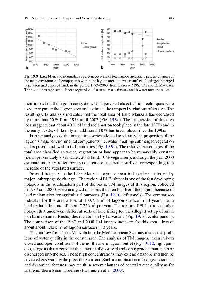
Fig. 19.9 Lake Manzala, a cumulative percent decrease of total lagoon area and b percent changes of
the main environmental components within the lagoon area, i.e. water surface, floating/submerged
vegetation and exposed land, in the period 1973–2003, from Landsat MSS, TM and ETM+ data.
The solid lines represent a linear regression of a total area estimates and b water area estimates
their impact on the lagoon ecosystem. Unsupervised classification techniques were
used to separate the lagoon area and estimate the temporal variations of its size. The
resulting GIS analysis indicates that the total area of Lake Manzala has decreased
by more than 50 % from 1973 until 2003 (Fig. 19.9a). The progression of this area
loss suggests that about 40 % of land reclamation took place in the late 1970s and in
the early 1980s, while only an additional 10 % has taken place since the 1990s.
Further analysis of the image time series allowed to identify the proportion of the
lagoon’s major environmental components, i.e. water, floating/ submerged vegetation
and exposed land, within its boundaries (Fig. 19.9b). The relative percentages of the
total area classified as water, vegetation or land appear to be remarkably constant
(i.e. approximately 70 % water, 20 % land, 10 % vegetation), although the year 2000
estimate indicates a (temporary) decrease of the water surface, corresponding to a
increase of the vegetated surface.
Several hotspots in the Lake Manzala region appear to have been affected by
major anthropogenic changes. The region of El-Bashteer is one of the fast developing
hotspots in the southeastern part of the basin. TM images of this region, collected
in 1987 and 2000, were analyzed to assess the area lost from the lagoon because of
land reclamation for agricultural purposes (Fig. 19.10, left panels). The comparison
indicates for this area a loss of 100.73 km
2 of lagoon surface in 13 years, i.e. a
land reclamation rate of about 7.75 km
2 per year. The region of El-Jenka is another
hotspot that underwent different sorts of land filling for the (illegal) set up of small
fish farms (named Hosha) destined to fish fry harvesting (Fig. 19.10, center panels).
The comparison of the 1987 and 2000 TM images indicates for this area a loss of
about about 8.45 km
2 of lagoon surface in 13 years.
The outflow from Lake Manzala into the Mediterranean Sea may also cause problems of water quality in the coastal area. The analysis of TM images, taken in both
closed and open conditions of the northeastern lagoon outlet (Fig. 19.10, right panels), suggests that a considerable amount of dissolved and/or suspended matter can be
discharged into the sea. These high concentrations may extend offshore and then be
advected eastward by the prevailing current. Such a combination of bio-geo-chemical
and dynamical features may result in severe changes of coastal water quality as far
as the northern Sinai shoreline (Rasmussen et al. 2009).
393
Fig. 19.9 Lake Manzala, a cumulative percent decrease of total lagoon area and b percent changes of
the main environmental components within the lagoon area, i.e. water surface, floating/submerged
vegetation and exposed land, in the period 1973–2003, from Landsat MSS, TM and ETM+ data.
The solid lines represent a linear regression of a total area estimates and b water area estimates
their impact on the lagoon ecosystem. Unsupervised classification techniques were
used to separate the lagoon area and estimate the temporal variations of its size. The
resulting GIS analysis indicates that the total area of Lake Manzala has decreased
by more than 50 % from 1973 until 2003 (Fig. 19.9a). The progression of this area
loss suggests that about 40 % of land reclamation took place in the late 1970s and in
the early 1980s, while only an additional 10 % has taken place since the 1990s.
Further analysis of the image time series allowed to identify the proportion of the
lagoon’s major environmental components, i.e. water, floating/ submerged vegetation
and exposed land, within its boundaries (Fig. 19.9b). The relative percentages of the
total area classified as water, vegetation or land appear to be remarkably constant
(i.e. approximately 70 % water, 20 % land, 10 % vegetation), although the year 2000
estimate indicates a (temporary) decrease of the water surface, corresponding to a
increase of the vegetated surface.
Several hotspots in the Lake Manzala region appear to have been affected by
major anthropogenic changes. The region of El-Bashteer is one of the fast developing
hotspots in the southeastern part of the basin. TM images of this region, collected
in 1987 and 2000, were analyzed to assess the area lost from the lagoon because of
land reclamation for agricultural purposes (Fig. 19.10, left panels). The comparison
indicates for this area a loss of 100.73 km
2 of lagoon surface in 13 years, i.e. a
land reclamation rate of about 7.75 km
2 per year. The region of El-Jenka is another
hotspot that underwent different sorts of land filling for the (illegal) set up of small
fish farms (named Hosha) destined to fish fry harvesting (Fig. 19.10, center panels).
The comparison of the 1987 and 2000 TM images indicates for this area a loss of
about about 8.45 km
2 of lagoon surface in 13 years.
The outflow from Lake Manzala into the Mediterranean Sea may also cause problems of water quality in the coastal area. The analysis of TM images, taken in both
closed and open conditions of the northeastern lagoon outlet (Fig. 19.10, right panels), suggests that a considerable amount of dissolved and/or suspended matter can be
discharged into the sea. These high concentrations may extend offshore and then be
advected eastward by the prevailing current. Such a combination of bio-geo-chemical
and dynamical features may result in severe changes of coastal water quality as far
as the northern Sinai shoreline (Rasmussen et al. 2009).