

290
S. Lehner et al.
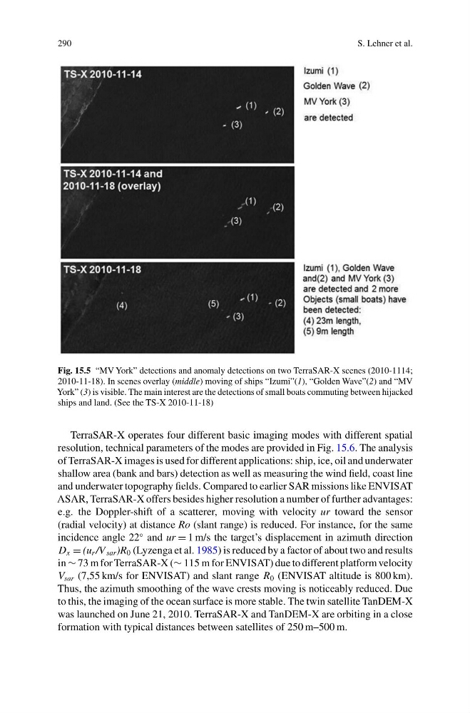
Fig. 15.5 “MV York” detections and anomaly detections on two TerraSAR-X scenes (2010-1114;
2010-11-18). In scenes overlay (middle) moving of ships “Izumi”(1), “Golden Wave”(2) and “MV
York” (3) is visible. The main interest are the detections of small boats commuting between hijacked
ships and land. (See the TS-X 2010-11-18)
TerraSAR-X operates four different basic imaging modes with different spatial
resolution, technical parameters of the modes are provided in Fig. 15.6. The analysis
of TerraSAR-X images is used for different applications: ship, ice, oil and underwater
shallow area (bank and bars) detection as well as measuring the wind field, coast line
and underwater topography fields. Compared to earlier SAR missions like ENVISAT
ASAR, TerraSAR-X offers besides higher resolution a number of further advantages:
e.g. the Doppler-shift of a scatterer, moving with velocity ur toward the sensor
(radial velocity) at distance Ro (slant range) is reduced. For instance, for the same
incidence angle 22
◦ and ur = 1 m/s the target’s displacement in azimuth direction
D x = (u r /V sar )R 0 (Lyzenga et al. 1985) is reduced by a factor of about two and results
in ∼ 73 m for TerraSAR-X (∼ 115 m for ENVISAT) due to different platform velocity
V sar (7,55 km/s for ENVISAT) and slant range R 0 (ENVISAT altitude is 800 km).
Thus, the azimuth smoothing of the wave crests moving is noticeably reduced. Due
to this, the imaging of the ocean surface is more stable. The twin satellite TanDEM-X
was launched on June 21, 2010. TerraSAR-X and TanDEM-X are orbiting in a close
formation with typical distances between satellites of 250 m–500 m.
S. Lehner et al.
Fig. 15.5 “MV York” detections and anomaly detections on two TerraSAR-X scenes (2010-1114;
2010-11-18). In scenes overlay (middle) moving of ships “Izumi”(1), “Golden Wave”(2) and “MV
York” (3) is visible. The main interest are the detections of small boats commuting between hijacked
ships and land. (See the TS-X 2010-11-18)
TerraSAR-X operates four different basic imaging modes with different spatial
resolution, technical parameters of the modes are provided in Fig. 15.6. The analysis
of TerraSAR-X images is used for different applications: ship, ice, oil and underwater
shallow area (bank and bars) detection as well as measuring the wind field, coast line
and underwater topography fields. Compared to earlier SAR missions like ENVISAT
ASAR, TerraSAR-X offers besides higher resolution a number of further advantages:
e.g. the Doppler-shift of a scatterer, moving with velocity ur toward the sensor
(radial velocity) at distance Ro (slant range) is reduced. For instance, for the same
incidence angle 22
◦ and ur = 1 m/s the target’s displacement in azimuth direction
D x = (u r /V sar )R 0 (Lyzenga et al. 1985) is reduced by a factor of about two and results
in ∼ 73 m for TerraSAR-X (∼ 115 m for ENVISAT) due to different platform velocity
V sar (7,55 km/s for ENVISAT) and slant range R 0 (ENVISAT altitude is 800 km).
Thus, the azimuth smoothing of the wave crests moving is noticeably reduced. Due
to this, the imaging of the ocean surface is more stable. The twin satellite TanDEM-X
was launched on June 21, 2010. TerraSAR-X and TanDEM-X are orbiting in a close
formation with typical distances between satellites of 250 m–500 m.