

288
S. Lehner et al.
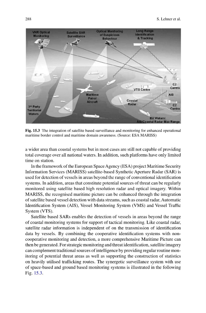
Fig. 15.3 The integration of satellite based surveillance and monitoring for enhanced operational
maritime border control and maritime domain awareness. (Source: ESA MARISS)
a wider area than coastal systems but in most cases are still not capable of providing
total coverage over all national waters. In addition, such platforms have only limited
time on station.
In the framework of the European Space Agency (ESA) project Maritime Security
Information Services (MARISS) satellite-based Synthetic Aperture Radar (SAR) is
used for detection of vessels in areas beyond the range of conventional identification
systems. In addition, areas that constitute potential sources of threat can be regularly
monitored using satellite based high resolution radar and optical imagery. Within
MARISS, the recognised maritime picture can be enhanced through the integration
of satellite based vessel detection with data streams, such as coastal radar, Automatic
Identification System (AIS), Vessel Monitoring System (VMS) and Vessel Traffic
System (VTS).
Satellite based SARs enables the detection of vessels in areas beyond the range
of coastal monitoring systems for support of tactical monitoring. Like coastal radar,
satellite radar information is independent of on the transmission of identification
data by vessels. By combining the cooperative identification systems with noncooperative monitoring and detection, a more comprehensive Maritime Picture can
then be generated. For strategic monitoring and threat identification, satellite imagery
can complement traditional sources of intelligence by providing regular routine monitoring of potential threat areas as well as supporting the construction of statistics
on heavily utilised trafficking routes. The synergetic surveillance system with use
of space-based and ground based monitoring systems is illustrated in the following
Fig. 15.3.
S. Lehner et al.
Fig. 15.3 The integration of satellite based surveillance and monitoring for enhanced operational
maritime border control and maritime domain awareness. (Source: ESA MARISS)
a wider area than coastal systems but in most cases are still not capable of providing
total coverage over all national waters. In addition, such platforms have only limited
time on station.
In the framework of the European Space Agency (ESA) project Maritime Security
Information Services (MARISS) satellite-based Synthetic Aperture Radar (SAR) is
used for detection of vessels in areas beyond the range of conventional identification
systems. In addition, areas that constitute potential sources of threat can be regularly
monitored using satellite based high resolution radar and optical imagery. Within
MARISS, the recognised maritime picture can be enhanced through the integration
of satellite based vessel detection with data streams, such as coastal radar, Automatic
Identification System (AIS), Vessel Monitoring System (VMS) and Vessel Traffic
System (VTS).
Satellite based SARs enables the detection of vessels in areas beyond the range
of coastal monitoring systems for support of tactical monitoring. Like coastal radar,
satellite radar information is independent of on the transmission of identification
data by vessels. By combining the cooperative identification systems with noncooperative monitoring and detection, a more comprehensive Maritime Picture can
then be generated. For strategic monitoring and threat identification, satellite imagery
can complement traditional sources of intelligence by providing regular routine monitoring of potential threat areas as well as supporting the construction of statistics
on heavily utilised trafficking routes. The synergetic surveillance system with use
of space-based and ground based monitoring systems is illustrated in the following
Fig. 15.3.