

4 Remote Sensing of African Coastal Waters Using Active Microwaves Instrument
87
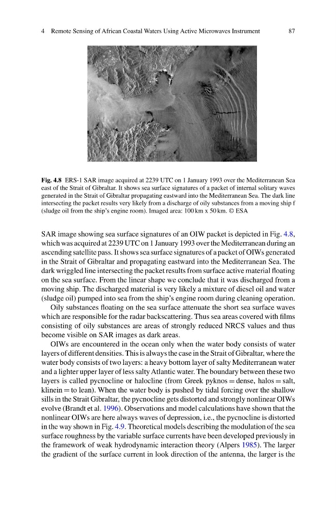
Fig. 4.8 ERS-1 SAR image acquired at 2239 UTC on 1 January 1993 over the Mediterranean Sea
east of the Strait of Gibraltar. It shows sea surface signatures of a packet of internal solitary waves
generated in the Strait of Gibraltar propagating eastward into the Mediterranean Sea. The dark line
intersecting the packet results very likely from a discharge of oily substances from a moving ship f
(sludge oil from the ship’s engine room). Imaged area: 100 km x 50 km. © ESA
SAR image showing sea surface signatures of an OIW packet is depicted in Fig. 4.8,
which was acquired at 2239 UTC on 1 January 1993 over the Mediterranean during an
ascending satellite pass. It shows sea surface signatures of a packet of OIWs generated
in the Strait of Gibraltar and propagating eastward into the Mediterranean Sea. The
dark wriggled line intersecting the packet results from surface active material floating
on the sea surface. From the linear shape we conclude that it was discharged from a
moving ship. The discharged material is very likely a mixture of diesel oil and water
(sludge oil) pumped into sea from the ship’s engine room during cleaning operation.
Oily substances floating on the sea surface attenuate the short sea surface waves
which are responsible for the radar backscattering. Thus sea areas covered with films
consisting of oily substances are areas of strongly reduced NRCS values and thus
become visible on SAR images as dark areas.
OIWs are encountered in the ocean only when the water body consists of water
layers of different densities. This is always the case in the Strait of Gibraltar, where the
water body consists of two layers: a heavy bottom layer of salty Mediterranean water
and a lighter upper layer of less salty Atlantic water. The boundary between these two
layers is called pycnocline or halocline (from Greek pyknos = dense, halos = salt,
klinein = to lean). When the water body is pushed by tidal forcing over the shallow
sills in the Strait Gibraltar, the pycnocline gets distorted and strongly nonlinear OIWs
evolve (Brandt et al. 1996). Observations and model calculations have shown that the
nonlinear OIWs are here always waves of depression, i.e., the pycnocline is distorted
in the way shown in Fig. 4.9. Theoretical models describing the modulation of the sea
surface roughness by the variable surface currents have been developed previously in
the framework of weak hydrodynamic interaction theory (Alpers 1985). The larger
the gradient of the surface current in look direction of the antenna, the larger is the
87
Fig. 4.8 ERS-1 SAR image acquired at 2239 UTC on 1 January 1993 over the Mediterranean Sea
east of the Strait of Gibraltar. It shows sea surface signatures of a packet of internal solitary waves
generated in the Strait of Gibraltar propagating eastward into the Mediterranean Sea. The dark line
intersecting the packet results very likely from a discharge of oily substances from a moving ship f
(sludge oil from the ship’s engine room). Imaged area: 100 km x 50 km. © ESA
SAR image showing sea surface signatures of an OIW packet is depicted in Fig. 4.8,
which was acquired at 2239 UTC on 1 January 1993 over the Mediterranean during an
ascending satellite pass. It shows sea surface signatures of a packet of OIWs generated
in the Strait of Gibraltar and propagating eastward into the Mediterranean Sea. The
dark wriggled line intersecting the packet results from surface active material floating
on the sea surface. From the linear shape we conclude that it was discharged from a
moving ship. The discharged material is very likely a mixture of diesel oil and water
(sludge oil) pumped into sea from the ship’s engine room during cleaning operation.
Oily substances floating on the sea surface attenuate the short sea surface waves
which are responsible for the radar backscattering. Thus sea areas covered with films
consisting of oily substances are areas of strongly reduced NRCS values and thus
become visible on SAR images as dark areas.
OIWs are encountered in the ocean only when the water body consists of water
layers of different densities. This is always the case in the Strait of Gibraltar, where the
water body consists of two layers: a heavy bottom layer of salty Mediterranean water
and a lighter upper layer of less salty Atlantic water. The boundary between these two
layers is called pycnocline or halocline (from Greek pyknos = dense, halos = salt,
klinein = to lean). When the water body is pushed by tidal forcing over the shallow
sills in the Strait Gibraltar, the pycnocline gets distorted and strongly nonlinear OIWs
evolve (Brandt et al. 1996). Observations and model calculations have shown that the
nonlinear OIWs are here always waves of depression, i.e., the pycnocline is distorted
in the way shown in Fig. 4.9. Theoretical models describing the modulation of the sea
surface roughness by the variable surface currents have been developed previously in
the framework of weak hydrodynamic interaction theory (Alpers 1985). The larger
the gradient of the surface current in look direction of the antenna, the larger is the