

4 Remote Sensing of African Coastal Waters Using Active Microwaves Instrument
85
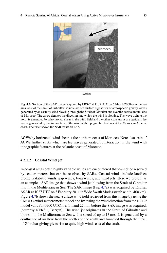
Fig. 4.6 Section of the SAR image acquired by ERS-2 at 1105 UTC on 6 March 2000 over the sea
area west of the Strait of Gibraltar. Visible are sea surface signatures of atmospheric gravity waves
generated by an easterly wind blowing through the Strait of Gibraltar and over the coastal mountains
of Morocco. The arrow denotes the direction into which the wind is blowing, The wave train to the
north is generated by a horizontal shear in the wind field and the other wave trains are typically lee
waves generated by the interaction of the wind with topographic features at the Moroccan Atlantic
coast. The inset shows the SAR swath © ESA
AGWs by horizontal wind shear at the northern coast of Morocco. Note also train of
AGWs further south which are lee waves generated by interaction of the wind with
topographic features at the Atlantic coast of Morocco.
4.3.1.2 Coastal Wind Jet
In coastal areas often highly variable winds are encountered that cannot be resolved
by scatterometers, but can be resolved by SARs. Coastal winds include land/sea
breeze, katabatic winds, gap winds, bora winds, and wind jets. Here we present as
an example a SAR image that shows a wind jet blowing from the Strait of Gibraltar
into in the Mediterranean Sea. The SAR image (Fig. 4.7a) was acquired by Envisat
ASAR at 1027 UTC on 3 February 2011 in Wide Swath Mode (swath width: 400 km).
Figure 4.7b shows the near-surface wind field retrieved from this image by using the
CMOD 4 wind scatterometer model and by taking the wind direction from the NCEP
model valid for 0900 UTC, i.e. 1 h and 27 min before the SAR image was acquired.
(courtesy NERSC, Bergen). The wind jet originates in the Strait of Gibraltar and
blows into the Mediterranean Sea with a speed of up to 13 m/s. It is generated by a
confluence of air flow from the north and the south and funneled through the Strait
of Gibraltar giving gives rise to quite high winds east of the strait.
85
Fig. 4.6 Section of the SAR image acquired by ERS-2 at 1105 UTC on 6 March 2000 over the sea
area west of the Strait of Gibraltar. Visible are sea surface signatures of atmospheric gravity waves
generated by an easterly wind blowing through the Strait of Gibraltar and over the coastal mountains
of Morocco. The arrow denotes the direction into which the wind is blowing, The wave train to the
north is generated by a horizontal shear in the wind field and the other wave trains are typically lee
waves generated by the interaction of the wind with topographic features at the Moroccan Atlantic
coast. The inset shows the SAR swath © ESA
AGWs by horizontal wind shear at the northern coast of Morocco. Note also train of
AGWs further south which are lee waves generated by interaction of the wind with
topographic features at the Atlantic coast of Morocco.
4.3.1.2 Coastal Wind Jet
In coastal areas often highly variable winds are encountered that cannot be resolved
by scatterometers, but can be resolved by SARs. Coastal winds include land/sea
breeze, katabatic winds, gap winds, bora winds, and wind jets. Here we present as
an example a SAR image that shows a wind jet blowing from the Strait of Gibraltar
into in the Mediterranean Sea. The SAR image (Fig. 4.7a) was acquired by Envisat
ASAR at 1027 UTC on 3 February 2011 in Wide Swath Mode (swath width: 400 km).
Figure 4.7b shows the near-surface wind field retrieved from this image by using the
CMOD 4 wind scatterometer model and by taking the wind direction from the NCEP
model valid for 0900 UTC, i.e. 1 h and 27 min before the SAR image was acquired.
(courtesy NERSC, Bergen). The wind jet originates in the Strait of Gibraltar and
blows into the Mediterranean Sea with a speed of up to 13 m/s. It is generated by a
confluence of air flow from the north and the south and funneled through the Strait
of Gibraltar giving gives rise to quite high winds east of the strait.