

increased by 54 %. Monthly precipitation data was then used to determine river
discharge for two time frames, 1974–1992 and 1993–2002. The results showed a
higher runoff to precipitation ratio for the later period. For their second study site,
Simms Creek watershed in Florida (USA), they used Landsat imagery (2000 and
1984) to identify urban land use. This time, they used Manning’s roughness
coefficient, SCS-CNs, and simulated rainfall. They found more areas of 100 %
impervious surfaces in 2000 than in 1984 and also found an increase in peak
discharge and reduced time to peak in 2000 as compared to 1984.
5.2 Urban Land Use and Hydrology
Hydrology of urban areas is extremely complex [47]. Urban hydrology includes
stormwater runoff from impervious surfaces, less evapotranspiration, less groundwater infiltration, treatment and distribution of potable water, and wastewater
treatment and discharge. The initial focus of urban hydrology planning was identification of the most efficient ways to redirect stormwater flow in the shortest amount
of time [48]. This strategy increased impervious surface area designations beyond
those designed for roadways and buildings, and which channelized streams above
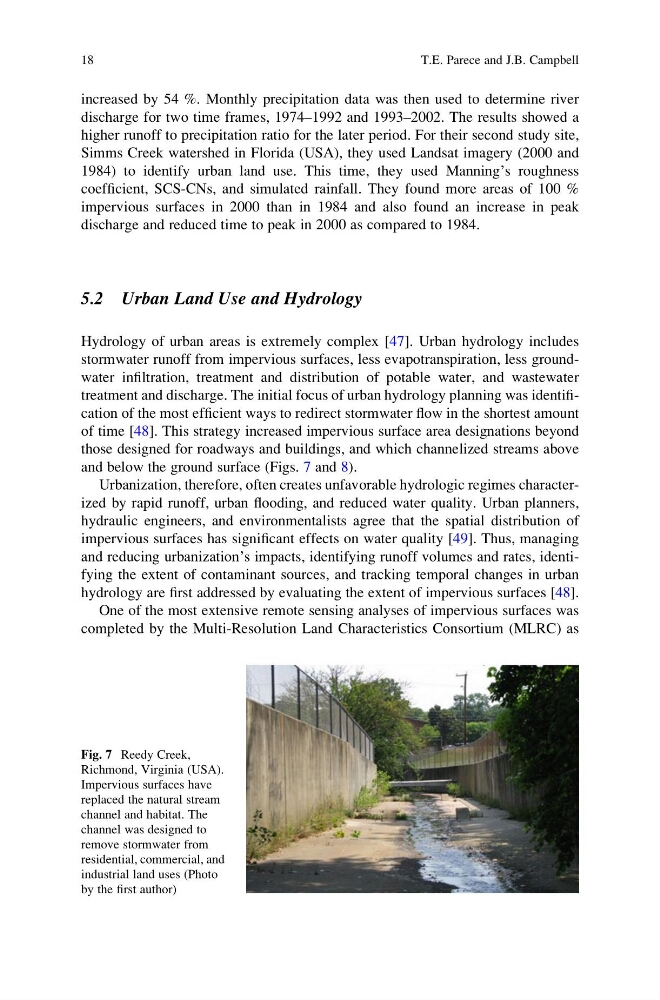
and below the ground surface (Figs. 7 and 8).
Urbanization, therefore, often creates unfavorable hydrologic regimes characterized by rapid runoff, urban flooding, and reduced water quality. Urban planners,
hydraulic engineers, and environmentalists agree that the spatial distribution of
impervious surfaces has significant effects on water quality [49]. Thus, managing
and reducing urbanization’s impacts, identifying runoff volumes and rates, identifying the extent of contaminant sources, and tracking temporal changes in urban
hydrology are first addressed by evaluating the extent of impervious surfaces [48].
One of the most extensive remote sensing analyses of impervious surfaces was
completed by the Multi-Resolution Land Characteristics Consortium (MLRC) as
Fig. 7 Reedy Creek,
Richmond, Virginia (USA).
Impervious surfaces have
replaced the natural stream
channel and habitat. The
channel was designed to
remove stormwater from
residential, commercial, and
industrial land uses (Photo
by the first author)
18
T.E. Parece and J.B. Campbell
discharge for two time frames, 1974–1992 and 1993–2002. The results showed a
higher runoff to precipitation ratio for the later period. For their second study site,
Simms Creek watershed in Florida (USA), they used Landsat imagery (2000 and
1984) to identify urban land use. This time, they used Manning’s roughness
coefficient, SCS-CNs, and simulated rainfall. They found more areas of 100 %
impervious surfaces in 2000 than in 1984 and also found an increase in peak
discharge and reduced time to peak in 2000 as compared to 1984.
5.2 Urban Land Use and Hydrology
Hydrology of urban areas is extremely complex [47]. Urban hydrology includes
stormwater runoff from impervious surfaces, less evapotranspiration, less groundwater infiltration, treatment and distribution of potable water, and wastewater
treatment and discharge. The initial focus of urban hydrology planning was identification of the most efficient ways to redirect stormwater flow in the shortest amount
of time [48]. This strategy increased impervious surface area designations beyond
those designed for roadways and buildings, and which channelized streams above
and below the ground surface (Figs. 7 and 8).
Urbanization, therefore, often creates unfavorable hydrologic regimes characterized by rapid runoff, urban flooding, and reduced water quality. Urban planners,
hydraulic engineers, and environmentalists agree that the spatial distribution of
impervious surfaces has significant effects on water quality [49]. Thus, managing
and reducing urbanization’s impacts, identifying runoff volumes and rates, identifying the extent of contaminant sources, and tracking temporal changes in urban
hydrology are first addressed by evaluating the extent of impervious surfaces [48].
One of the most extensive remote sensing analyses of impervious surfaces was
completed by the Multi-Resolution Land Characteristics Consortium (MLRC) as
Fig. 7 Reedy Creek,
Richmond, Virginia (USA).
Impervious surfaces have
replaced the natural stream
channel and habitat. The
channel was designed to
remove stormwater from
residential, commercial, and
industrial land uses (Photo
by the first author)
18
T.E. Parece and J.B. Campbell