

3.7 Interactive Mapping Tool
The tool under development for this project includes an online interactive map
interface which displays time series of total monthly consumptive use in userselected watersheds and also enables the users to access and review underlying
data. Consumptive use in each watershed is computed according to Eq. (2), using
spatial queries, as the sum of all withdrawals minus the sum of all estimated return
flows occurring in the watershed. Return flows are estimated from withdrawal data
and consumptive use coefficients and routed using the Water Balance Conveyance
Model described in the previous section.
In order to meet budget constraints and provide a system that could be easily
shared, open-source software was selected for the mapping tool architecture. Opensource software is generally defined as software that can be used, modified, and
redistributed without any restrictions, limitations, or royalty payments and usually
includes the source code for the software [40]. Using a variety of open-source
software, a prototype system has been developed that is flexible in accommodating
a wide array of data formats and spatial data types, but also scalable for large
volumes of data.
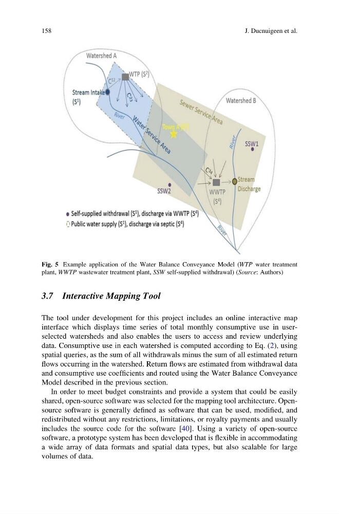
Fig. 5 Example application of the Water Balance Conveyance Model (WTP water treatment
plant, WWTP wastewater treatment plant, SSW self-supplied withdrawal) (Source: Authors)
158
J. Ducnuigeen et al.
The tool under development for this project includes an online interactive map
interface which displays time series of total monthly consumptive use in userselected watersheds and also enables the users to access and review underlying
data. Consumptive use in each watershed is computed according to Eq. (2), using
spatial queries, as the sum of all withdrawals minus the sum of all estimated return
flows occurring in the watershed. Return flows are estimated from withdrawal data
and consumptive use coefficients and routed using the Water Balance Conveyance
Model described in the previous section.
In order to meet budget constraints and provide a system that could be easily
shared, open-source software was selected for the mapping tool architecture. Opensource software is generally defined as software that can be used, modified, and
redistributed without any restrictions, limitations, or royalty payments and usually
includes the source code for the software [40]. Using a variety of open-source
software, a prototype system has been developed that is flexible in accommodating
a wide array of data formats and spatial data types, but also scalable for large
volumes of data.
Fig. 5 Example application of the Water Balance Conveyance Model (WTP water treatment
plant, WWTP wastewater treatment plant, SSW self-supplied withdrawal) (Source: Authors)
158
J. Ducnuigeen et al.