

3.3 Aquatic Vegetation Mapping and Changes
Aquatic vegetation or macrophytes are fundamental components of aquatic ecosystems, providing numerous ecological functions. Littoral vegetation, mainly
constituted by common reed beds (Phragmites sp.) in Lake Taihu, provides nitrogen transformation and nitrogen loss functions [33], while floating macrophytes
(in particular Trapa sp.), present in abundance in eastern Lake Taihu, control
sediment resuspension and influence the lake’s phosphorous cycle [34]. Ma
et al. [35] mapped the extent and temporal changes of aquatic vegetation communities throughout Lake Taihu by remote sensing, identifying a reduction of 90 km
2
between 2001 and 2007, with a loss of nearly 20 % of total macrophytes biomass in
the lake [35]. Remote sensing can provide crucial information about specific land
cover change features from multi-temporal datasets [e.g., 36].
In this case study, we explored changes in macrophytes coverage in 2000 and
2010, using data from the peak macrophytes extent in 2000 and 2010: Landsat
5 TM, acquired on 17 September 2000, and Landsat 7 ETM+, acquired on
21 September 2010.
January
February
March
April
May
June
July
August
September
October
November
December
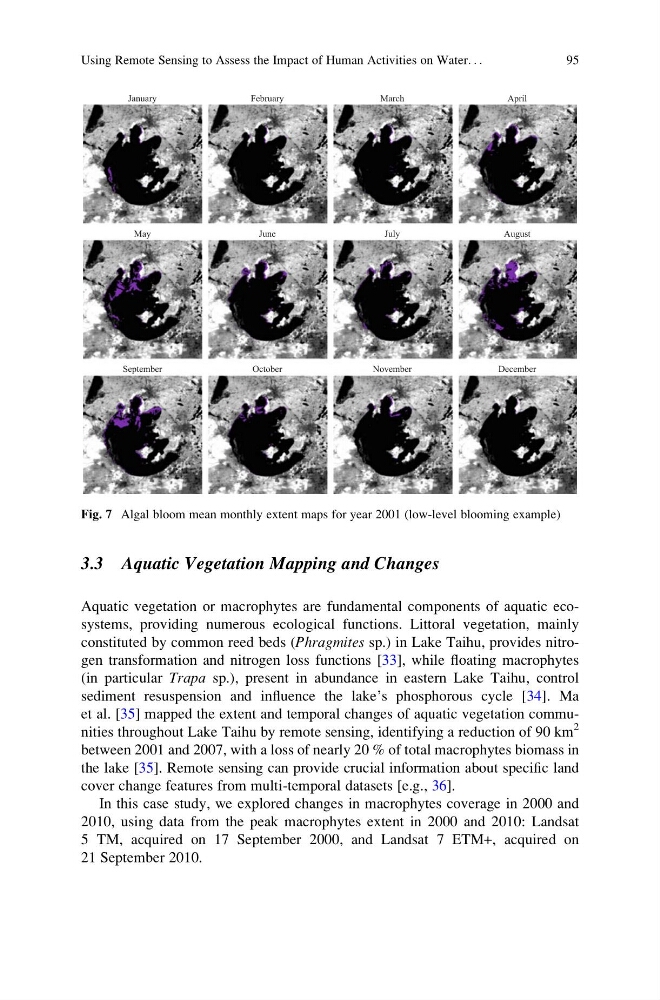
Fig. 7 Algal bloom mean monthly extent maps for year 2001 (low-level blooming example)
Using Remote Sensing to Assess the Impact of Human Activities on Water. . .
95
Aquatic vegetation or macrophytes are fundamental components of aquatic ecosystems, providing numerous ecological functions. Littoral vegetation, mainly
constituted by common reed beds (Phragmites sp.) in Lake Taihu, provides nitrogen transformation and nitrogen loss functions [33], while floating macrophytes
(in particular Trapa sp.), present in abundance in eastern Lake Taihu, control
sediment resuspension and influence the lake’s phosphorous cycle [34]. Ma
et al. [35] mapped the extent and temporal changes of aquatic vegetation communities throughout Lake Taihu by remote sensing, identifying a reduction of 90 km
2
between 2001 and 2007, with a loss of nearly 20 % of total macrophytes biomass in
the lake [35]. Remote sensing can provide crucial information about specific land
cover change features from multi-temporal datasets [e.g., 36].
In this case study, we explored changes in macrophytes coverage in 2000 and
2010, using data from the peak macrophytes extent in 2000 and 2010: Landsat
5 TM, acquired on 17 September 2000, and Landsat 7 ETM+, acquired on
21 September 2010.
January
February
March
April
May
June
July
August
September
October
November
December
Fig. 7 Algal bloom mean monthly extent maps for year 2001 (low-level blooming example)
Using Remote Sensing to Assess the Impact of Human Activities on Water. . .
95