

130
forest with extensive wetlands and abundant and diverse wildlife populations (Sykes
1937; Leopold 1949). Annual river discharges that could reach 7000 m
3
/s and transport substantial suspended sediment and organic matter supported habitat and wildlife (Cohen et al. 2001; Zamora et al. 2013). As water and sediment inputs ceased
during filling of large upstream reservoirs during the 1930s–1960s, the delta became
mostly a saline tidal flat. When the reservoir above Glen Canyon Dam finally
reached capacity in 1981, flows began to again reach the delta during years of heavy
precipitation in the drainage basin. These flows were small and of short duration,
however, relative to historical flows to the delta. As of 2013, the river reached the
ocean on average 12 days per year (Zamora et al. 2013). The United States has also
discharged appreciable quantities of agricultural return flows into the southeastern
portion of the delta since 1977, creating a large, brackish marsh known as Cienega
de Santa Clara (Nelson et al. 2013) (Fig. 4.13). In an effort to further revitalize the
delta, the US and Mexico agreed to an environmental flow release to the delta in
spring 2014. The environmental effects of releasing 130 million m
3
of water during
this experiment were intensely monitored (Glenn et al. 2013) and included minor,
localized erosion and deposition; germination of native vegetation; and ground
water recharge (Mueller et al. 2016). The experimental delta flow was a small but
symbolically important start to the process of revitalizing the Colorado River delta
ecosystem.
The examples of the Danube, the Mareiterbach, the Kissimmee, and the Colorado
each illustrate a shift in river management toward increasing physical complexity
and connectivity of river corridors. Management of these rivers now focuses more
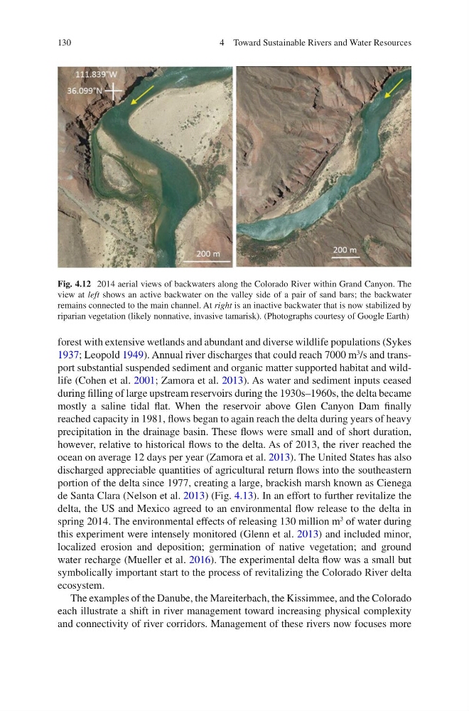
Fig. 4.12 2014 aerial views of backwaters along the Colorado River within Grand Canyon. The
view at left shows an active backwater on the valley side of a pair of sand bars; the backwater
remains connected to the main channel. At right is an inactive backwater that is now stabilized by
riparian vegetation (likely nonnative, invasive tamarisk). (Photographs courtesy of Google Earth)
4 Toward Sustainable Rivers and Water Resources
forest with extensive wetlands and abundant and diverse wildlife populations (Sykes
1937; Leopold 1949). Annual river discharges that could reach 7000 m
3
/s and transport substantial suspended sediment and organic matter supported habitat and wildlife (Cohen et al. 2001; Zamora et al. 2013). As water and sediment inputs ceased
during filling of large upstream reservoirs during the 1930s–1960s, the delta became
mostly a saline tidal flat. When the reservoir above Glen Canyon Dam finally
reached capacity in 1981, flows began to again reach the delta during years of heavy
precipitation in the drainage basin. These flows were small and of short duration,
however, relative to historical flows to the delta. As of 2013, the river reached the
ocean on average 12 days per year (Zamora et al. 2013). The United States has also
discharged appreciable quantities of agricultural return flows into the southeastern
portion of the delta since 1977, creating a large, brackish marsh known as Cienega
de Santa Clara (Nelson et al. 2013) (Fig. 4.13). In an effort to further revitalize the
delta, the US and Mexico agreed to an environmental flow release to the delta in
spring 2014. The environmental effects of releasing 130 million m
3
of water during
this experiment were intensely monitored (Glenn et al. 2013) and included minor,
localized erosion and deposition; germination of native vegetation; and ground
water recharge (Mueller et al. 2016). The experimental delta flow was a small but
symbolically important start to the process of revitalizing the Colorado River delta
ecosystem.
The examples of the Danube, the Mareiterbach, the Kissimmee, and the Colorado
each illustrate a shift in river management toward increasing physical complexity
and connectivity of river corridors. Management of these rivers now focuses more
Fig. 4.12 2014 aerial views of backwaters along the Colorado River within Grand Canyon. The
view at left shows an active backwater on the valley side of a pair of sand bars; the backwater
remains connected to the main channel. At right is an inactive backwater that is now stabilized by
riparian vegetation (likely nonnative, invasive tamarisk). (Photographs courtesy of Google Earth)
4 Toward Sustainable Rivers and Water Resources