

Nitrate Water Pollution Risk in the Lower Jordan Valley
239
There are many pollution sources located inside the valley that will affect not
only the Pleistocene aquifers, but also the upper soil layers that have connections
to the shallow groundwater embedded in the alluvial layers of the Jordan River.
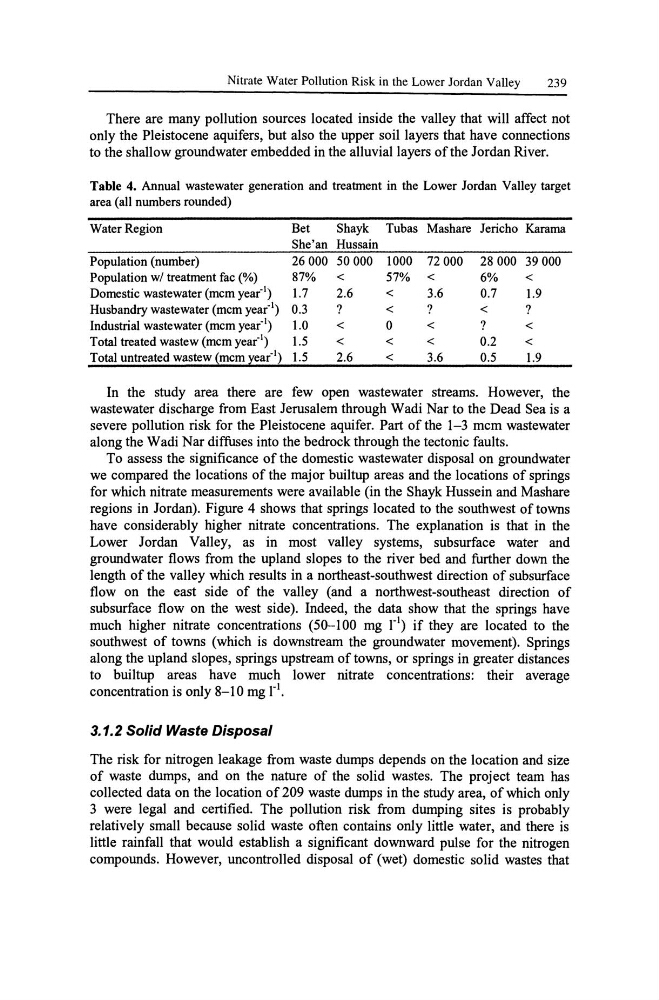
Table 4. Annual wastewater generation and treatment in the Lower Jordan Valley target
area (all numbers rounded)
Water Region
Bet
Shayk Tubas Mashare Jericho Karama
She'an Hussain
Population (number)
26000 50000 1000 72 000 28000 39000
Population wI treatment fac (%)
87%
<
57% <
6%
<
Domestic wastewater (mcm year-I)
1.7
2.6
<
3.6
0.7
1.9
Husbandry wastewater (mcm year-I) 0.3
?
<
?
<
?
Industrial wastewater (mcm year'l)
1.0
<
0
<
?
<
Total treated wastew (mcm year'l)
1.5
<
<
<
0.2
<
Total untreated wastew ~mcm ~ear'l) 1.5
2.6
<
3.6
0.5
1.9
In the study area there are few open wastewater streams. However, the
wastewater discharge from East Jerusalem through Wadi Nar to the Dead Sea is a
severe pollution risk for the Pleistocene aquifer. Part of the 1-3 mcm wastewater
along the Wadi Nar diffuses into the bedrock through the tectonic faults.
To assess the significance of the domestic wastewater disposal on groundwater
we compared the locations of the major builtup areas and the locations of springs
for which nitrate measurements were available (in the Shayk Hussein and Mashare
regions in Jordan). Figure 4 shows that springs located to the southwest of towns
have considerably higher nitrate concentrations. The explanation is that in the
Lower Jordan Valley, as in most valley systems, subsurface water and
groundwater flows from the upland slopes to the river bed and further down the
length of the valley which results in a northeast-southwest direction of subsurface
flow on the east side of the valley (and a northwest-southeast direction of
subsurface flow on the west side). Indeed, the data show that the springs have
much higher nitrate concentrations (50-100 mg 1'1) if they are located to the
southwest of towns (which is downstream the groundwater movement). Springs
along the upland slopes, springs upstream of towns, or springs in greater distances
to builtup areas have much lower nitrate concentrations: their average
concentration is only 8-10 mg 1'1.
3.1.2 Solid Waste Disposal
The risk for nitrogen leakage from waste dumps depends on the location and size
of waste dumps, and on the nature of the solid wastes. The project team has
collected data on the location of 209 waste dumps in the study area, of which only
3 were legal and certified. The pollution risk from dumping sites is probably
relatively small because solid waste often contains only little water, and there is
little rainfall that would establish a significant downward pulse for the nitrogen
compounds. However, uncontrolled disposal of (wet) domestic solid wastes that
239
There are many pollution sources located inside the valley that will affect not
only the Pleistocene aquifers, but also the upper soil layers that have connections
to the shallow groundwater embedded in the alluvial layers of the Jordan River.
Table 4. Annual wastewater generation and treatment in the Lower Jordan Valley target
area (all numbers rounded)
Water Region
Bet
Shayk Tubas Mashare Jericho Karama
She'an Hussain
Population (number)
26000 50000 1000 72 000 28000 39000
Population wI treatment fac (%)
87%
<
57% <
6%
<
Domestic wastewater (mcm year-I)
1.7
2.6
<
3.6
0.7
1.9
Husbandry wastewater (mcm year-I) 0.3
?
<
?
<
?
Industrial wastewater (mcm year'l)
1.0
<
0
<
?
<
Total treated wastew (mcm year'l)
1.5
<
<
<
0.2
<
Total untreated wastew ~mcm ~ear'l) 1.5
2.6
<
3.6
0.5
1.9
In the study area there are few open wastewater streams. However, the
wastewater discharge from East Jerusalem through Wadi Nar to the Dead Sea is a
severe pollution risk for the Pleistocene aquifer. Part of the 1-3 mcm wastewater
along the Wadi Nar diffuses into the bedrock through the tectonic faults.
To assess the significance of the domestic wastewater disposal on groundwater
we compared the locations of the major builtup areas and the locations of springs
for which nitrate measurements were available (in the Shayk Hussein and Mashare
regions in Jordan). Figure 4 shows that springs located to the southwest of towns
have considerably higher nitrate concentrations. The explanation is that in the
Lower Jordan Valley, as in most valley systems, subsurface water and
groundwater flows from the upland slopes to the river bed and further down the
length of the valley which results in a northeast-southwest direction of subsurface
flow on the east side of the valley (and a northwest-southeast direction of
subsurface flow on the west side). Indeed, the data show that the springs have
much higher nitrate concentrations (50-100 mg 1'1) if they are located to the
southwest of towns (which is downstream the groundwater movement). Springs
along the upland slopes, springs upstream of towns, or springs in greater distances
to builtup areas have much lower nitrate concentrations: their average
concentration is only 8-10 mg 1'1.
3.1.2 Solid Waste Disposal
The risk for nitrogen leakage from waste dumps depends on the location and size
of waste dumps, and on the nature of the solid wastes. The project team has
collected data on the location of 209 waste dumps in the study area, of which only
3 were legal and certified. The pollution risk from dumping sites is probably
relatively small because solid waste often contains only little water, and there is
little rainfall that would establish a significant downward pulse for the nitrogen
compounds. However, uncontrolled disposal of (wet) domestic solid wastes that