

12
L. Le Dû-Blayo and O. Musard
Landscape
mapping
Landscape
ecology
Planning / ELC
Landscaping
Descriptors and
scales
Matrix
Corridor
Patch
Unit
Structure
Component
Atmosphere
Structure
Feature
Title
Typology of
habitats
Landscape atlas
Landscape design
ObjecƟves
Good
environmental
status
Biodiversity
Landscape quality
Diversity / identy
Landscape
amenies
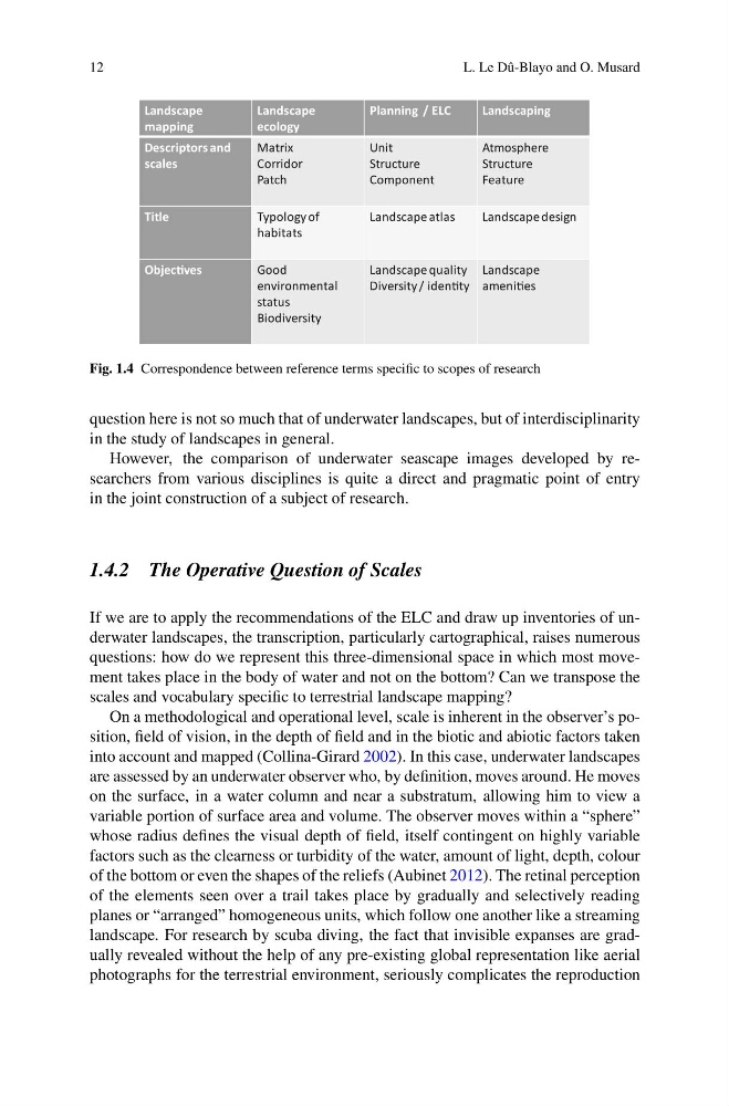
Fig. 1.4 Correspondence between reference terms specific to scopes of research
question here is not so much that of underwater landscapes, but of interdisciplinarity
in the study of landscapes in general.
However, the comparison of underwater seascape images developed by researchers from various disciplines is quite a direct and pragmatic point of entry
in the joint construction of a subject of research.
1.4.2 The Operative Question of Scales
If we are to apply the recommendations of the ELC and draw up inventories of underwater landscapes, the transcription, particularly cartographical, raises numerous
questions: how do we represent this three-dimensional space in which most movement takes place in the body of water and not on the bottom? Can we transpose the
scales and vocabulary specific to terrestrial landscape mapping?
On a methodological and operational level, scale is inherent in the observer’s position, field of vision, in the depth of field and in the biotic and abiotic factors taken
into account and mapped (Collina-Girard 2002). In this case, underwater landscapes
are assessed by an underwater observer who, by definition, moves around. He moves
on the surface, in a water column and near a substratum, allowing him to view a
variable portion of surface area and volume. The observer moves within a “sphere”
whose radius defines the visual depth of field, itself contingent on highly variable
factors such as the clearness or turbidity of the water, amount of light, depth, colour
of the bottom or even the shapes of the reliefs (Aubinet 2012). The retinal perception
of the elements seen over a trail takes place by gradually and selectively reading
planes or “arranged” homogeneous units, which follow one another like a streaming
landscape. For research by scuba diving, the fact that invisible expanses are gradually revealed without the help of any pre-existing global representation like aerial
photographs for the terrestrial environment, seriously complicates the reproduction
L. Le Dû-Blayo and O. Musard
Landscape
mapping
Landscape
ecology
Planning / ELC
Landscaping
Descriptors and
scales
Matrix
Corridor
Patch
Unit
Structure
Component
Atmosphere
Structure
Feature
Title
Typology of
habitats
Landscape atlas
Landscape design
ObjecƟves
Good
environmental
status
Biodiversity
Landscape quality
Diversity / identy
Landscape
amenies
Fig. 1.4 Correspondence between reference terms specific to scopes of research
question here is not so much that of underwater landscapes, but of interdisciplinarity
in the study of landscapes in general.
However, the comparison of underwater seascape images developed by researchers from various disciplines is quite a direct and pragmatic point of entry
in the joint construction of a subject of research.
1.4.2 The Operative Question of Scales
If we are to apply the recommendations of the ELC and draw up inventories of underwater landscapes, the transcription, particularly cartographical, raises numerous
questions: how do we represent this three-dimensional space in which most movement takes place in the body of water and not on the bottom? Can we transpose the
scales and vocabulary specific to terrestrial landscape mapping?
On a methodological and operational level, scale is inherent in the observer’s position, field of vision, in the depth of field and in the biotic and abiotic factors taken
into account and mapped (Collina-Girard 2002). In this case, underwater landscapes
are assessed by an underwater observer who, by definition, moves around. He moves
on the surface, in a water column and near a substratum, allowing him to view a
variable portion of surface area and volume. The observer moves within a “sphere”
whose radius defines the visual depth of field, itself contingent on highly variable
factors such as the clearness or turbidity of the water, amount of light, depth, colour
of the bottom or even the shapes of the reliefs (Aubinet 2012). The retinal perception
of the elements seen over a trail takes place by gradually and selectively reading
planes or “arranged” homogeneous units, which follow one another like a streaming
landscape. For research by scuba diving, the fact that invisible expanses are gradually revealed without the help of any pre-existing global representation like aerial
photographs for the terrestrial environment, seriously complicates the reproduction