

1 Introduction: Towards a Shared Language: Semantic Exchanges . . .
11
Themes
RepresentaƟons
Natural factors
Landscape composiƟon
PercepƟons
RepresentaƟons
- Volcanism, Erosion, Sedimentaon, etc.
- Current, temperature, salinity,
- light, pressure
Etc.
Geological map
Bathymetric chart
Simulaon of currents and temperatures
Etc.
- Landform, paleovalley, canyon,
slope, block
- Mosaic, habitat, zone, facies, selement,
biocoenosis, biotope, corridor
- Landscape paern, landscape unit,
landscape structure, landscape
component
Map of habitat distribuon
Block diagram, cross-secons
Photographic observatory
Etc.
- Mobility, displacement
- Depth of field, readability
- Ambiance, atmosphere
Map of tours, dive sites
Types of access
High angle shot, low angle shot, angles,
framing
Lines, horizontality, vercality
- Lovely, rich, majesc, banal, quality
- Characterisc, outstanding
- Diversified, fragmented, monotonous
- Chromac complexity
- Plan, composion, harmony
Photography, Films, Comic strips
Literature, sound
Graphic arts
Virtual images
Heritage value
Etc.
Projects
- Destrucon, conservaon, preservaon,
restoraon, risk, challenges
- Integrity, alteraon
- Sensivity, resilience
- Planning, management, enhancement,
exploitaon
Resource mapping ,
Fishing zones, dredging, off shore
Use mapping
Underwater trail marking
Idenficaon of areas for protecon
Vocabulary
Etc.
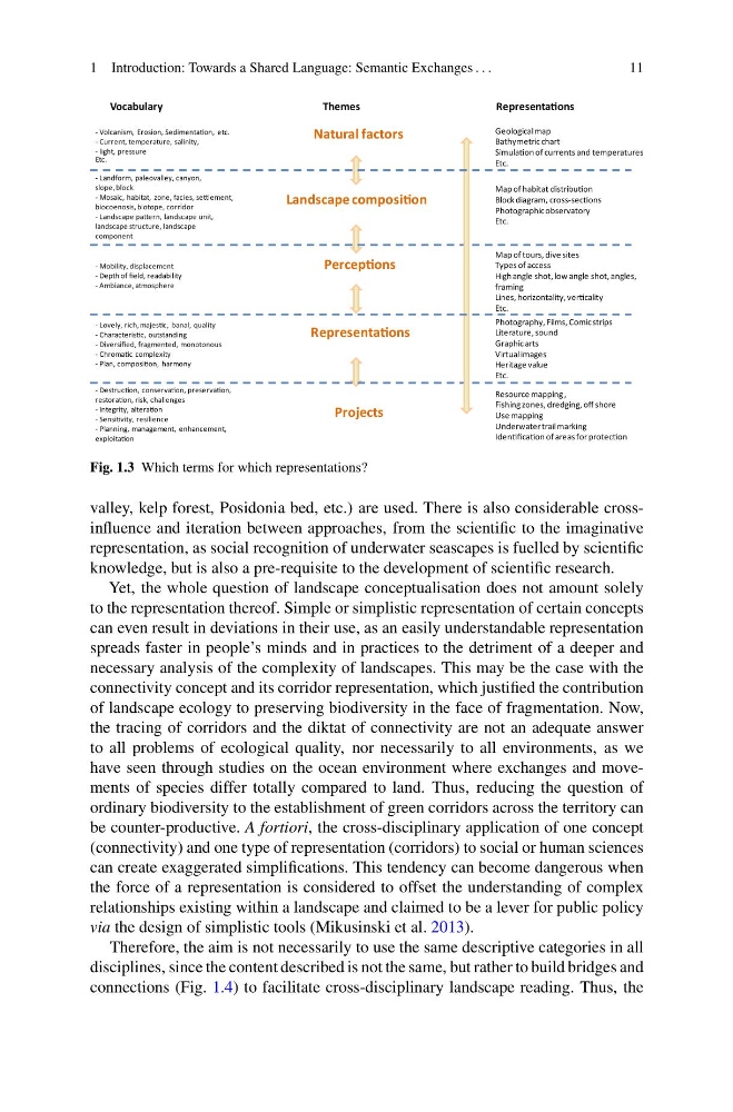
Fig. 1.3 Which terms for which representations?
valley, kelp forest, Posidonia bed, etc.) are used. There is also considerable crossinfluence and iteration between approaches, from the scientific to the imaginative
representation, as social recognition of underwater seascapes is fuelled by scientific
knowledge, but is also a pre-requisite to the development of scientific research.
Yet, the whole question of landscape conceptualisation does not amount solely
to the representation thereof. Simple or simplistic representation of certain concepts
can even result in deviations in their use, as an easily understandable representation
spreads faster in people’s minds and in practices to the detriment of a deeper and
necessary analysis of the complexity of landscapes. This may be the case with the
connectivity concept and its corridor representation, which justified the contribution
of landscape ecology to preserving biodiversity in the face of fragmentation. Now,
the tracing of corridors and the diktat of connectivity are not an adequate answer
to all problems of ecological quality, nor necessarily to all environments, as we
have seen through studies on the ocean environment where exchanges and movements of species differ totally compared to land. Thus, reducing the question of
ordinary biodiversity to the establishment of green corridors across the territory can
be counter-productive. A fortiori, the cross-disciplinary application of one concept
(connectivity) and one type of representation (corridors) to social or human sciences
can create exaggerated simplifications. This tendency can become dangerous when
the force of a representation is considered to offset the understanding of complex
relationships existing within a landscape and claimed to be a lever for public policy
via the design of simplistic tools (Mikusinski et al. 2013).
Therefore, the aim is not necessarily to use the same descriptive categories in all
disciplines, since the content described is not the same, but rather to build bridges and
connections (Fig. 1.4) to facilitate cross-disciplinary landscape reading. Thus, the
11
Themes
RepresentaƟons
Natural factors
Landscape composiƟon
PercepƟons
RepresentaƟons
- Volcanism, Erosion, Sedimentaon, etc.
- Current, temperature, salinity,
- light, pressure
Etc.
Geological map
Bathymetric chart
Simulaon of currents and temperatures
Etc.
- Landform, paleovalley, canyon,
slope, block
- Mosaic, habitat, zone, facies, selement,
biocoenosis, biotope, corridor
- Landscape paern, landscape unit,
landscape structure, landscape
component
Map of habitat distribuon
Block diagram, cross-secons
Photographic observatory
Etc.
- Mobility, displacement
- Depth of field, readability
- Ambiance, atmosphere
Map of tours, dive sites
Types of access
High angle shot, low angle shot, angles,
framing
Lines, horizontality, vercality
- Lovely, rich, majesc, banal, quality
- Characterisc, outstanding
- Diversified, fragmented, monotonous
- Chromac complexity
- Plan, composion, harmony
Photography, Films, Comic strips
Literature, sound
Graphic arts
Virtual images
Heritage value
Etc.
Projects
- Destrucon, conservaon, preservaon,
restoraon, risk, challenges
- Integrity, alteraon
- Sensivity, resilience
- Planning, management, enhancement,
exploitaon
Resource mapping ,
Fishing zones, dredging, off shore
Use mapping
Underwater trail marking
Idenficaon of areas for protecon
Vocabulary
Etc.
Fig. 1.3 Which terms for which representations?
valley, kelp forest, Posidonia bed, etc.) are used. There is also considerable crossinfluence and iteration between approaches, from the scientific to the imaginative
representation, as social recognition of underwater seascapes is fuelled by scientific
knowledge, but is also a pre-requisite to the development of scientific research.
Yet, the whole question of landscape conceptualisation does not amount solely
to the representation thereof. Simple or simplistic representation of certain concepts
can even result in deviations in their use, as an easily understandable representation
spreads faster in people’s minds and in practices to the detriment of a deeper and
necessary analysis of the complexity of landscapes. This may be the case with the
connectivity concept and its corridor representation, which justified the contribution
of landscape ecology to preserving biodiversity in the face of fragmentation. Now,
the tracing of corridors and the diktat of connectivity are not an adequate answer
to all problems of ecological quality, nor necessarily to all environments, as we
have seen through studies on the ocean environment where exchanges and movements of species differ totally compared to land. Thus, reducing the question of
ordinary biodiversity to the establishment of green corridors across the territory can
be counter-productive. A fortiori, the cross-disciplinary application of one concept
(connectivity) and one type of representation (corridors) to social or human sciences
can create exaggerated simplifications. This tendency can become dangerous when
the force of a representation is considered to offset the understanding of complex
relationships existing within a landscape and claimed to be a lever for public policy
via the design of simplistic tools (Mikusinski et al. 2013).
Therefore, the aim is not necessarily to use the same descriptive categories in all
disciplines, since the content described is not the same, but rather to build bridges and
connections (Fig. 1.4) to facilitate cross-disciplinary landscape reading. Thus, the