

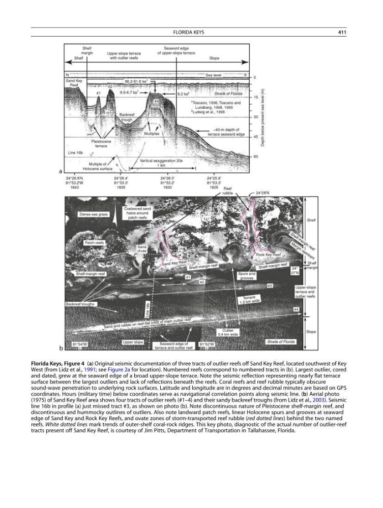
Florida Keys, Figure 4 (a) Original seismic documentation of three tracts of outlier reefs off Sand Key Reef, located southwest of Key
West (from Lidz et al., 1991; see Figure 2a for location). Numbered reefs correspond to numbered tracts in (b). Largest outlier, cored
and dated, grew at the seaward edge of a broad upper-slope terrace. Note the seismic reflection representing nearly flat terrace
surface between the largest outliers and lack of reflections beneath the reefs. Coral reefs and reef rubble typically obscure
sound-wave penetration to underlying rock surfaces. Latitude and longitude are in degrees and decimal minutes are based on GPS
coordinates. Hours (military time) below coordinates serve as navigational correlation points along seismic line. (b) Aerial photo
(1975) of Sand Key Reef area shows four tracts of outlier reefs (#1–4) and their sandy backreef troughs (from Lidz et al., 2003). Seismic
line 16b in profile (a) just missed tract #3, as shown on photo (b). Note discontinuous nature of Pleistocene shelf-margin reef, and
discontinuous and hummocky outlines of outliers. Also note landward patch reefs, linear Holocene spurs and grooves at seaward
edge of Sand Key and Rock Key Reefs, and ovate zones of storm-transported reef rubble (red dotted lines) behind the two named
reefs. White dotted lines mark trends of outer-shelf coral-rock ridges. This key photo, diagnostic of the actual number of outlier-reef
tracts present off Sand Key Reef, is courtesy of Jim Pitts, Department of Transportation in Tallahassee, Florida.
FLORIDA KEYS
411
West (from Lidz et al., 1991; see Figure 2a for location). Numbered reefs correspond to numbered tracts in (b). Largest outlier, cored
and dated, grew at the seaward edge of a broad upper-slope terrace. Note the seismic reflection representing nearly flat terrace
surface between the largest outliers and lack of reflections beneath the reefs. Coral reefs and reef rubble typically obscure
sound-wave penetration to underlying rock surfaces. Latitude and longitude are in degrees and decimal minutes are based on GPS
coordinates. Hours (military time) below coordinates serve as navigational correlation points along seismic line. (b) Aerial photo
(1975) of Sand Key Reef area shows four tracts of outlier reefs (#1–4) and their sandy backreef troughs (from Lidz et al., 2003). Seismic
line 16b in profile (a) just missed tract #3, as shown on photo (b). Note discontinuous nature of Pleistocene shelf-margin reef, and
discontinuous and hummocky outlines of outliers. Also note landward patch reefs, linear Holocene spurs and grooves at seaward
edge of Sand Key and Rock Key Reefs, and ovate zones of storm-transported reef rubble (red dotted lines) behind the two named
reefs. White dotted lines mark trends of outer-shelf coral-rock ridges. This key photo, diagnostic of the actual number of outlier-reef
tracts present off Sand Key Reef, is courtesy of Jim Pitts, Department of Transportation in Tallahassee, Florida.
FLORIDA KEYS
411