

a proxy, they proposed a “wind index” to reflect the gradual loss in wind and wave energy moving northward
toward the “horse latitudes.” This is clearly reflected in
the rose diagrams in Figure 5 based on synoptic,
fair-weather wave data compiled by the US Navy. Hubbard (1989) proposed that hurricane frequency and intensity might also play a role in this equation. Using
detailed records for the previous century, the likelihood
of major storms passing through 1-degree grid squares
across the Caribbean and western Atlantic were tabulated.
Contours of the highest return frequencies were used to
identify the most likely storm tracks through the region
(red arrows in Figure 5).
The highest fair-weather waves plus the most common
and severe storms occur near the boundary between the
Windward and Leeward Islands. Near Guadalupe, Category
3–5 hurricanes strike almost annually, minimizing
branching acroporids along the reef crest. In the interim,
Atlantic swell creates a high-energy environment that discourages grazing. The result is an accumulation of coralline
algae that build thick, wave-resistant structures (Adey and
Burke, 1976, 1977: see area 1 in Figure 5). In the northwestern Caribbean and western Atlantic (area 2 in Figure 5),
storms are still common but generally less severe. Fairweather wave climate is benign compared to the more
exposed Windward Islands. Because Acropora palmata is
extremely sensitive to sediment stress (Adey et al., 1977b;
Rogers, 1983), it relies on wave action to clear sediment.
Thus, a reef-crest community dominated by branching corals
is difficult to support in all but the most energetic areas
(e.g., where winter swell impacts the Bahamas). Smaller
waves also make grazing easier, precluding the accumulation
of thick coralline crusts (Adey and Burke, 1977). Reef crests
dominated by hardgrounds and massive corals tend to be
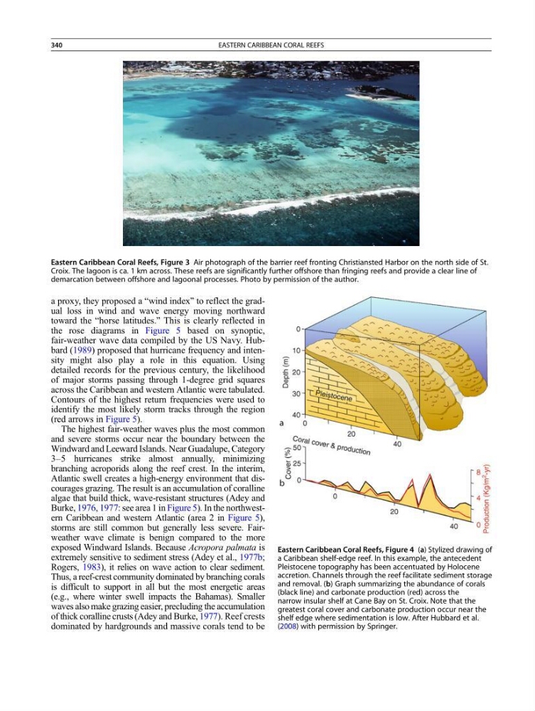
Eastern Caribbean Coral Reefs, Figure 3 Air photograph of the barrier reef fronting Christiansted Harbor on the north side of St.
Croix. The lagoon is ca. 1 km across. These reefs are significantly further offshore than fringing reefs and provide a clear line of
demarcation between offshore and lagoonal processes. Photo by permission of the author.
Eastern Caribbean Coral Reefs, Figure 4 (a) Stylized drawing of
a Caribbean shelf-edge reef. In this example, the antecedent
Pleistocene topography has been accentuated by Holocene
accretion. Channels through the reef facilitate sediment storage
and removal. (b) Graph summarizing the abundance of corals
(black line) and carbonate production (red) across the
narrow insular shelf at Cane Bay on St. Croix. Note that the
greatest coral cover and carbonate production occur near the
shelf edge where sedimentation is low. After Hubbard et al.
(2008) with permission by Springer.
340
EASTERN CARIBBEAN CORAL REEFS
toward the “horse latitudes.” This is clearly reflected in
the rose diagrams in Figure 5 based on synoptic,
fair-weather wave data compiled by the US Navy. Hubbard (1989) proposed that hurricane frequency and intensity might also play a role in this equation. Using
detailed records for the previous century, the likelihood
of major storms passing through 1-degree grid squares
across the Caribbean and western Atlantic were tabulated.
Contours of the highest return frequencies were used to
identify the most likely storm tracks through the region
(red arrows in Figure 5).
The highest fair-weather waves plus the most common
and severe storms occur near the boundary between the
Windward and Leeward Islands. Near Guadalupe, Category
3–5 hurricanes strike almost annually, minimizing
branching acroporids along the reef crest. In the interim,
Atlantic swell creates a high-energy environment that discourages grazing. The result is an accumulation of coralline
algae that build thick, wave-resistant structures (Adey and
Burke, 1976, 1977: see area 1 in Figure 5). In the northwestern Caribbean and western Atlantic (area 2 in Figure 5),
storms are still common but generally less severe. Fairweather wave climate is benign compared to the more
exposed Windward Islands. Because Acropora palmata is
extremely sensitive to sediment stress (Adey et al., 1977b;
Rogers, 1983), it relies on wave action to clear sediment.
Thus, a reef-crest community dominated by branching corals
is difficult to support in all but the most energetic areas
(e.g., where winter swell impacts the Bahamas). Smaller
waves also make grazing easier, precluding the accumulation
of thick coralline crusts (Adey and Burke, 1977). Reef crests
dominated by hardgrounds and massive corals tend to be
Eastern Caribbean Coral Reefs, Figure 3 Air photograph of the barrier reef fronting Christiansted Harbor on the north side of St.
Croix. The lagoon is ca. 1 km across. These reefs are significantly further offshore than fringing reefs and provide a clear line of
demarcation between offshore and lagoonal processes. Photo by permission of the author.
Eastern Caribbean Coral Reefs, Figure 4 (a) Stylized drawing of
a Caribbean shelf-edge reef. In this example, the antecedent
Pleistocene topography has been accentuated by Holocene
accretion. Channels through the reef facilitate sediment storage
and removal. (b) Graph summarizing the abundance of corals
(black line) and carbonate production (red) across the
narrow insular shelf at Cane Bay on St. Croix. Note that the
greatest coral cover and carbonate production occur near the
shelf edge where sedimentation is low. After Hubbard et al.
(2008) with permission by Springer.
340
EASTERN CARIBBEAN CORAL REEFS