

There are minor ridges developed on the lagoon shore, and
the teloks experience restricted exchange of water with the
lagoon. A similar sequence of ridges, resembling a crab
claw, extend on either side of the southern passage, and
the distinct succession of ridges that extend from the
southeastern shore of West Island appears to be gradually
decreasing water movement over the intertidal flats in
their lee.
There are extensive areas of the atoll rim and of the
lagoon flats that are intertidal and which shoal, or dry,
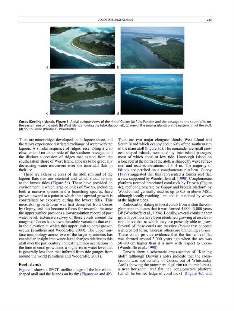
at the lowest tides (Figure 3c). These have provided an
environment in which large colonies of Porites, including
both a massive species and a branching species, have
grown upward to a point at which their upward growth is
constrained by exposure during the lowest tides. This
microatoll growth form was first described from Cocos
by Guppy, and has become a focus for research, because
the upper surface provides a low-resolution record of past
water level. Extensive survey of these corals around the
margin of Cocos has shown the subtle variations that exist
in the elevation at which this upper limit to coral growth
occurs (Smithers and Woodroffe, 2000). The upper surface morphology across two of the larger specimens has
enabled an insight into water-level changes relative to this
atoll over the past century, indicating minor oscillations in
the limit of coral growth and a slight rise in water level that
is generally less than that inferred from tide gauges from
around the world (Smithers and Woodroffe, 2001).
Reef islands
Figure 1 shows a SPOT satellite image of the horseshoeshaped atoll and the islands on its rim (Figures 4a and 4b).
There are two major elongate islands, West Island and
South Island which occupy about 60% of the southern rim
of the main atoll (Figure 3d). The remainder are small crescent-shaped islands, separated by inter-island passages,
most of which shoal at low tide. Horsburgh Island on
a lone reef at the north of the atoll, is shaped by wave refraction and reaches elevations of 3–4 m. The majority of
islands are perched on a conglomerate platform. Guppy
(1889) suggested that this represented a former reef flat,
a view supported by Woodroffe et al. (1990). Conglomerate
platform (termed brecciated coral-rock by Darwin (Figure
4c), reef conglomerate by Guppy and breccia platform by
Wood-Jones) generally reaches up to 0.5 m above MSL,
although locally reaching 1 m, and is inundated by waves
at the highest tides.
Radiocarbon dating of fossil corals from within the conglomerate indicates that it was formed 4,000–3,000 years
BP (Woodroffe et al., 1994). Locally, several corals in their
growth position have been identified growing at an elevation above that to which they are presently able to grow.
Several of these corals are massive Porites that adopted
a microatoll form, whereas others are branching Porites.
These corals provide evidence that the former reef flat
was formed around 3,000 years ago when the sea was
50–80 cm higher than it is now with respect to Cocos
(Woodroffe et al., 1990).
Darwin drew a schematic cross-section of “Keeling
atoll” (although Darwin’s notes indicate that the crosssection was not actually of Cocos, but of Whitsunday
Atoll) showing the prominent algal rim (at the reef crest),
a near horizontal reef flat, the conglomerate platform
(which he termed ledge of coral rock) (Figure 4c), and
Cocos (Keeling) Islands, Figure 3 Aerial oblique views of the rim of Cocos: (a) Pulu Pandan and the passage to the south of it, on
the eastern rim of the atoll; (b) West Island showing the telok (lagoonlet); (c) one of the smaller islands on the eastern rim of the atoll;
(d) South Island (Photos C. Woodroffe).
COCOS (KEELING) ISLANDS
223
the teloks experience restricted exchange of water with the
lagoon. A similar sequence of ridges, resembling a crab
claw, extend on either side of the southern passage, and
the distinct succession of ridges that extend from the
southeastern shore of West Island appears to be gradually
decreasing water movement over the intertidal flats in
their lee.
There are extensive areas of the atoll rim and of the
lagoon flats that are intertidal and which shoal, or dry,
at the lowest tides (Figure 3c). These have provided an
environment in which large colonies of Porites, including
both a massive species and a branching species, have
grown upward to a point at which their upward growth is
constrained by exposure during the lowest tides. This
microatoll growth form was first described from Cocos
by Guppy, and has become a focus for research, because
the upper surface provides a low-resolution record of past
water level. Extensive survey of these corals around the
margin of Cocos has shown the subtle variations that exist
in the elevation at which this upper limit to coral growth
occurs (Smithers and Woodroffe, 2000). The upper surface morphology across two of the larger specimens has
enabled an insight into water-level changes relative to this
atoll over the past century, indicating minor oscillations in
the limit of coral growth and a slight rise in water level that
is generally less than that inferred from tide gauges from
around the world (Smithers and Woodroffe, 2001).
Reef islands
Figure 1 shows a SPOT satellite image of the horseshoeshaped atoll and the islands on its rim (Figures 4a and 4b).
There are two major elongate islands, West Island and
South Island which occupy about 60% of the southern rim
of the main atoll (Figure 3d). The remainder are small crescent-shaped islands, separated by inter-island passages,
most of which shoal at low tide. Horsburgh Island on
a lone reef at the north of the atoll, is shaped by wave refraction and reaches elevations of 3–4 m. The majority of
islands are perched on a conglomerate platform. Guppy
(1889) suggested that this represented a former reef flat,
a view supported by Woodroffe et al. (1990). Conglomerate
platform (termed brecciated coral-rock by Darwin (Figure
4c), reef conglomerate by Guppy and breccia platform by
Wood-Jones) generally reaches up to 0.5 m above MSL,
although locally reaching 1 m, and is inundated by waves
at the highest tides.
Radiocarbon dating of fossil corals from within the conglomerate indicates that it was formed 4,000–3,000 years
BP (Woodroffe et al., 1994). Locally, several corals in their
growth position have been identified growing at an elevation above that to which they are presently able to grow.
Several of these corals are massive Porites that adopted
a microatoll form, whereas others are branching Porites.
These corals provide evidence that the former reef flat
was formed around 3,000 years ago when the sea was
50–80 cm higher than it is now with respect to Cocos
(Woodroffe et al., 1990).
Darwin drew a schematic cross-section of “Keeling
atoll” (although Darwin’s notes indicate that the crosssection was not actually of Cocos, but of Whitsunday
Atoll) showing the prominent algal rim (at the reef crest),
a near horizontal reef flat, the conglomerate platform
(which he termed ledge of coral rock) (Figure 4c), and
Cocos (Keeling) Islands, Figure 3 Aerial oblique views of the rim of Cocos: (a) Pulu Pandan and the passage to the south of it, on
the eastern rim of the atoll; (b) West Island showing the telok (lagoonlet); (c) one of the smaller islands on the eastern rim of the atoll;
(d) South Island (Photos C. Woodroffe).
COCOS (KEELING) ISLANDS
223