

Atoll rim and Lagoon
The horseshoe-shaped rim of the atoll is near continuous
except in the northern part where there are openings
12–14-m deep, on the western and eastern side of
Horsburgh Island. Drilling and radiocarbon dating indicate that the Holocene rim has accumulated over the Last
Interglacial reef limestone encountered at depths of
10–14 m below sea level (Woodroffe et al., 1994)
(Figure 2). This older limestone, which represents the
rim of an atoll that formed the last time the sea was at or
close to its present level, is extremely porous and it plays
a significant role in the groundwater hydrology of the atoll
(Woodroffe and Falkland, 1997).
The lagoon covers about 190 km
2 and comprises a number of distinct areas. There are shallow sand flats that
occur in the lee of South Island, which dry at lowest tides,
and support a cover of seagrass. Much of the southern part
of the lagoon comprises a reticulate pattern of reefs, some
of which are 0–3-m deep, others which are exposed at the
lowest tide. This network of reefs separates deeper holes,
termed blueholes. These reach 20 m or more deep and
have a sporadic cover of branching or foliose corals, much
of which is dead. They harbor sharks in their murky
waters. The northern lagoon is 8–12-m deep and floored
largely with sandy sediments.
The lagoon is incompletely flushed because the interisland passages are shallow and many dry at low tide
(Figure 3a), limiting their effectiveness for the exchange
of water from the ocean (Kench, 1998; Kench and
McLean, 2004). Sediment is carried into the lagoon and
there are sand sheets that are gradually infilling the
southernmost blueholes (Smithers et al., 1993). Minor
lagoonlets, termed teloks (Figure 3b), occur on the lagoon
side of the larger elongate islands. These are very shallow
and muddy areas separated from the ocean by a ridge.
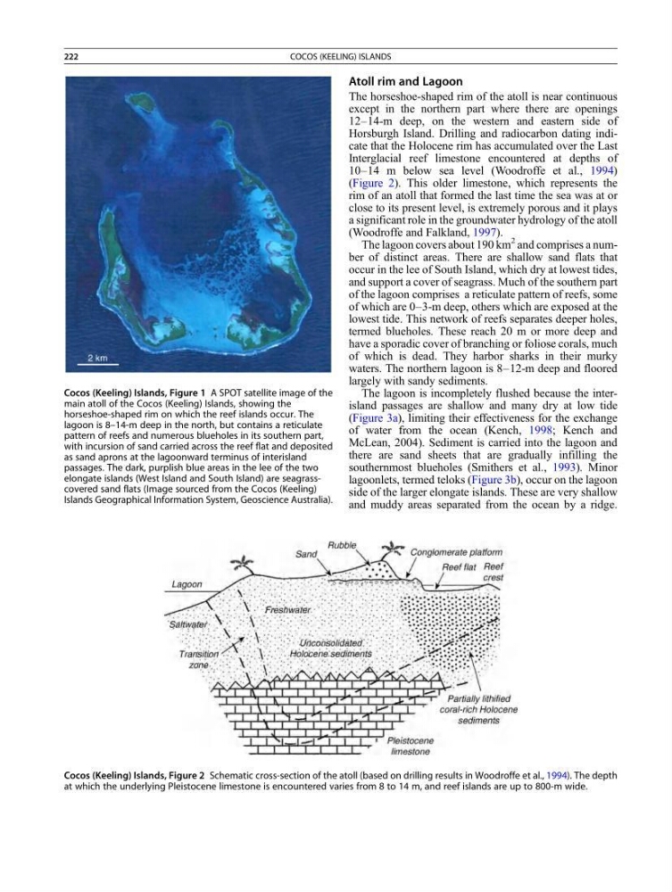
Cocos (Keeling) Islands, Figure 2 Schematic cross-section of the atoll (based on drilling results in Woodroffe et al., 1994). The depth
at which the underlying Pleistocene limestone is encountered varies from 8 to 14 m, and reef islands are up to 800-m wide.
Cocos (Keeling) Islands, Figure 1 A SPOT satellite image of the
main atoll of the Cocos (Keeling) Islands, showing the
horseshoe-shaped rim on which the reef islands occur. The
lagoon is 8–14-m deep in the north, but contains a reticulate
pattern of reefs and numerous blueholes in its southern part,
with incursion of sand carried across the reef flat and deposited
as sand aprons at the lagoonward terminus of interisland
passages. The dark, purplish blue areas in the lee of the two
elongate islands (West Island and South Island) are seagrasscovered sand flats (Image sourced from the Cocos (Keeling)
Islands Geographical Information System, Geoscience Australia).
222
COCOS (KEELING) ISLANDS
The horseshoe-shaped rim of the atoll is near continuous
except in the northern part where there are openings
12–14-m deep, on the western and eastern side of
Horsburgh Island. Drilling and radiocarbon dating indicate that the Holocene rim has accumulated over the Last
Interglacial reef limestone encountered at depths of
10–14 m below sea level (Woodroffe et al., 1994)
(Figure 2). This older limestone, which represents the
rim of an atoll that formed the last time the sea was at or
close to its present level, is extremely porous and it plays
a significant role in the groundwater hydrology of the atoll
(Woodroffe and Falkland, 1997).
The lagoon covers about 190 km
2 and comprises a number of distinct areas. There are shallow sand flats that
occur in the lee of South Island, which dry at lowest tides,
and support a cover of seagrass. Much of the southern part
of the lagoon comprises a reticulate pattern of reefs, some
of which are 0–3-m deep, others which are exposed at the
lowest tide. This network of reefs separates deeper holes,
termed blueholes. These reach 20 m or more deep and
have a sporadic cover of branching or foliose corals, much
of which is dead. They harbor sharks in their murky
waters. The northern lagoon is 8–12-m deep and floored
largely with sandy sediments.
The lagoon is incompletely flushed because the interisland passages are shallow and many dry at low tide
(Figure 3a), limiting their effectiveness for the exchange
of water from the ocean (Kench, 1998; Kench and
McLean, 2004). Sediment is carried into the lagoon and
there are sand sheets that are gradually infilling the
southernmost blueholes (Smithers et al., 1993). Minor
lagoonlets, termed teloks (Figure 3b), occur on the lagoon
side of the larger elongate islands. These are very shallow
and muddy areas separated from the ocean by a ridge.
Cocos (Keeling) Islands, Figure 2 Schematic cross-section of the atoll (based on drilling results in Woodroffe et al., 1994). The depth
at which the underlying Pleistocene limestone is encountered varies from 8 to 14 m, and reef islands are up to 800-m wide.
Cocos (Keeling) Islands, Figure 1 A SPOT satellite image of the
main atoll of the Cocos (Keeling) Islands, showing the
horseshoe-shaped rim on which the reef islands occur. The
lagoon is 8–14-m deep in the north, but contains a reticulate
pattern of reefs and numerous blueholes in its southern part,
with incursion of sand carried across the reef flat and deposited
as sand aprons at the lagoonward terminus of interisland
passages. The dark, purplish blue areas in the lee of the two
elongate islands (West Island and South Island) are seagrasscovered sand flats (Image sourced from the Cocos (Keeling)
Islands Geographical Information System, Geoscience Australia).
222
COCOS (KEELING) ISLANDS