

the seaward ridge of the island, steeper on the oceanward
side and sloping gradually toward the lagoon. Figure 2
shows a typical section of the eastern rim of the atoll. Many
of the islands show the typical cross-sectional morphology
that was sketched by Darwin, comprising an oceanward
ridge crest, a lower-lying central area, and a less prominent
lagoonward ridge. Islands are predominantly sandy,
although with shingle in some places, and coral boulders
along the oceanward shore of those on the eastern rim where
the reef flat is narrowest. There are a number of outcrops of
beachrock, bedded dipping parallel to the modern beach,
along several of the oceanward beaches (Figure 4d), and
occasional outcrops of cay sandstone, which is horizontally
bedded and less well lithified.
Darwin inferred different formative processes for
islands on windward and leeward sides of the atoll. On
the windward (eastern) side he considered that islands
accreted solely by addition of material on the oceanward
shores, whereas on the leeward (western) side he envisaged that island growth resulted from a combination of
oceanward accretion, augmented by lagoonward addition
of sediment by waves from the lagoon. By this mechanism, Darwin accounted for the wider islands on the leeward of the atoll. Radiocarbon dating has provided some
support for this pattern of accretion on West Island which
seems to have accumulated primarily by oceanward accretion, but also with some lagoonward growth (Woodroffe
et al., 1999). The crescent-shaped islands on the eastern
margin of Cocos were described in detail by Guppy
(1889) who proposed a model for their growth involving
spit elongation driven by unidirectional currents through
the inter-island channels. This evolutionary model has
not been fully tested by dating.
Islands are highest along their oceanward side. The
oceanward beach ridge is generally 3–4 m above MSL;
however, in some places the fine sand is winnowed from
the beach by wind and the beach ridge is topped by
a dune. Such dunes are not typical of atoll reef islands in
general. South Island has a dune ridge 6–7-m high,
reaching as high as 11 m on the southwestern corner of
South Island. West Island, which remains the administrative center, has an oceanward ridge that is characteristically 3–4 m above MSL (much of the southern part of
this island has been altered during runway construction),
but rises to 7 m above sea level in the area where residential buildings have been constructed on a dune. On Home
island, where the Cocos Malay kampong is found, the
oceanward ridge generally reaches an elevation of 3 m
above MSL, but at one location a dune rises up to 5 m
(Woodroffe and McLean, 1994).
Summary
The Cocos (Keeling) Islands consist of the main atoll of
Cocos, and the isolated North Keeling (Pulu Keeling)
which is Australia’s smallest Commonwealth National
Park. These rise from deep water, and the southern atoll
consists of a near continuous rim with linear islands on
the southern margin and a series of crescentic islands on
the eastern side. The islands are anchored in their present
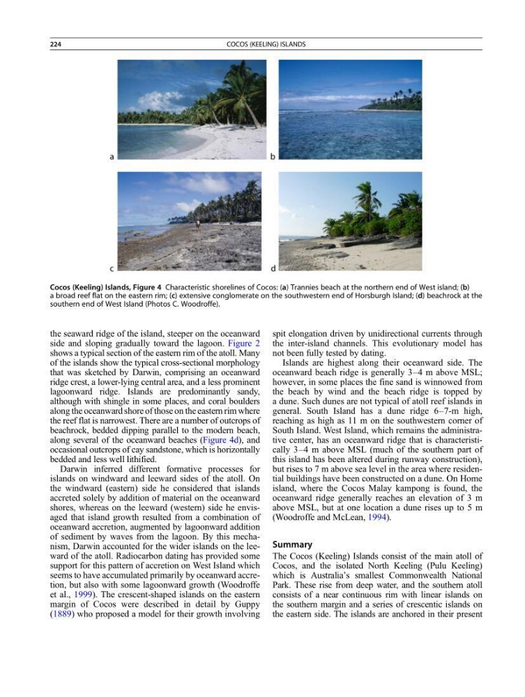
Cocos (Keeling) Islands, Figure 4 Characteristic shorelines of Cocos: (a) Trannies beach at the northern end of West island; (b)
a broad reef flat on the eastern rim; (c) extensive conglomerate on the southwestern end of Horsburgh Island; (d) beachrock at the
southern end of West Island (Photos C. Woodroffe).
224
COCOS (KEELING) ISLANDS
side and sloping gradually toward the lagoon. Figure 2
shows a typical section of the eastern rim of the atoll. Many
of the islands show the typical cross-sectional morphology
that was sketched by Darwin, comprising an oceanward
ridge crest, a lower-lying central area, and a less prominent
lagoonward ridge. Islands are predominantly sandy,
although with shingle in some places, and coral boulders
along the oceanward shore of those on the eastern rim where
the reef flat is narrowest. There are a number of outcrops of
beachrock, bedded dipping parallel to the modern beach,
along several of the oceanward beaches (Figure 4d), and
occasional outcrops of cay sandstone, which is horizontally
bedded and less well lithified.
Darwin inferred different formative processes for
islands on windward and leeward sides of the atoll. On
the windward (eastern) side he considered that islands
accreted solely by addition of material on the oceanward
shores, whereas on the leeward (western) side he envisaged that island growth resulted from a combination of
oceanward accretion, augmented by lagoonward addition
of sediment by waves from the lagoon. By this mechanism, Darwin accounted for the wider islands on the leeward of the atoll. Radiocarbon dating has provided some
support for this pattern of accretion on West Island which
seems to have accumulated primarily by oceanward accretion, but also with some lagoonward growth (Woodroffe
et al., 1999). The crescent-shaped islands on the eastern
margin of Cocos were described in detail by Guppy
(1889) who proposed a model for their growth involving
spit elongation driven by unidirectional currents through
the inter-island channels. This evolutionary model has
not been fully tested by dating.
Islands are highest along their oceanward side. The
oceanward beach ridge is generally 3–4 m above MSL;
however, in some places the fine sand is winnowed from
the beach by wind and the beach ridge is topped by
a dune. Such dunes are not typical of atoll reef islands in
general. South Island has a dune ridge 6–7-m high,
reaching as high as 11 m on the southwestern corner of
South Island. West Island, which remains the administrative center, has an oceanward ridge that is characteristically 3–4 m above MSL (much of the southern part of
this island has been altered during runway construction),
but rises to 7 m above sea level in the area where residential buildings have been constructed on a dune. On Home
island, where the Cocos Malay kampong is found, the
oceanward ridge generally reaches an elevation of 3 m
above MSL, but at one location a dune rises up to 5 m
(Woodroffe and McLean, 1994).
Summary
The Cocos (Keeling) Islands consist of the main atoll of
Cocos, and the isolated North Keeling (Pulu Keeling)
which is Australia’s smallest Commonwealth National
Park. These rise from deep water, and the southern atoll
consists of a near continuous rim with linear islands on
the southern margin and a series of crescentic islands on
the eastern side. The islands are anchored in their present
Cocos (Keeling) Islands, Figure 4 Characteristic shorelines of Cocos: (a) Trannies beach at the northern end of West island; (b)
a broad reef flat on the eastern rim; (c) extensive conglomerate on the southwestern end of Horsburgh Island; (d) beachrock at the
southern end of West Island (Photos C. Woodroffe).
224
COCOS (KEELING) ISLANDS