

contaminated a Japanese fishing boat (Daigo FukuryūMaru) that resulted in one death. Although the afflicted
atoll inhabitants were quickly evacuated after the blast,
many later suffered from radiation sickness. During the
subsequent half century, corals and anemones have
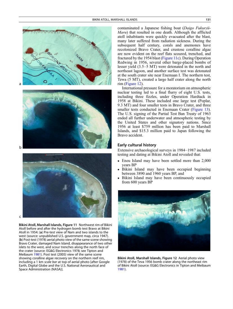
recolonized Bravo Crater, and crustose coralline algae
are now evident on the reef flats scoured, trenched, and
fractured by the 1954 blast (Figure 11c). During Operation
Redwing in 1956, several other barge-placed bombs of
lesser yield (3.5–5 MT) were detonated in the north and
northeast lagoon, and another surface test was detonated
at the south crater site near Enemaan I. The northern test,
Tewa (5 MT), created a large half crater along the north
rim (Figure 12).
International pressure for a moratorium on atmospheric
nuclear testing led to a final flurry of eight U.S. tests,
including three fizzles, under Operation Hardtack in
1958 at Bikini. These included one large test (Poplar,
9.3 MT) and four smaller tests in Bravo Crater, and three
smaller tests conducted in Enemaan Crater (Figure 13).
The U.S. signing of the Partial Test Ban Treaty of 1963
ended all further underwater and atmospheric testing by
the United States and other signatory nations. Since
1956 at least $759 million has been paid to Marshall
Islands, and $15.3 million paid to Japan following the
Bravo accident.
Early cultural history
Extensive archaeological surveys in 1984–1987 included
testing and dating at Bikini Atoll and revealed that:
Eneu Island may have been settled more than 2,000
years BP
Bikini Island may have been occupied beginning
between 3890 and 1960 years BP, and
Bikini Island may have been continuously occupied
from 600 years BP
Bikini Atoll, Marshall Islands, Figure 11 Northwest rim of Bikini
Atoll before and after the hydrogen bomb test Bravo at Bikini
Atoll in 1954: (a) Pre-test view of Nam and two islands to the
west (source: unpublished U.S. government map, circa 1947).
(b) Post-test (1978) aerial photo view of the same scene showing
Bravo Crater, damaged Nam Island, disappearance of two other
islets to the west, and scour trenches along the north face of
the crater (source: EG&G Electronics 1978; see Tipton and
Meibaum 1981). Post test (2005) view of the same scene
showing coralline algae recovery on the northern reef rim,
including a 1 km scale bar at top of aerial photo [after Google
Earth, Digital Globe and the U.S. National Aeronautical and
Space Administration (NASA)].
Bikini Atoll, Marshall Islands, Figure 12 Aerial photo view
(1978) of the Teva 1956 bomb crater along the northeast rim
of Bikini Atoll (source: EG&G Electronics in Tipton and Meibaum
1981).
BIKINI ATOLL, MARSHALL ISLANDS
131
atoll inhabitants were quickly evacuated after the blast,
many later suffered from radiation sickness. During the
subsequent half century, corals and anemones have
recolonized Bravo Crater, and crustose coralline algae
are now evident on the reef flats scoured, trenched, and
fractured by the 1954 blast (Figure 11c). During Operation
Redwing in 1956, several other barge-placed bombs of
lesser yield (3.5–5 MT) were detonated in the north and
northeast lagoon, and another surface test was detonated
at the south crater site near Enemaan I. The northern test,
Tewa (5 MT), created a large half crater along the north
rim (Figure 12).
International pressure for a moratorium on atmospheric
nuclear testing led to a final flurry of eight U.S. tests,
including three fizzles, under Operation Hardtack in
1958 at Bikini. These included one large test (Poplar,
9.3 MT) and four smaller tests in Bravo Crater, and three
smaller tests conducted in Enemaan Crater (Figure 13).
The U.S. signing of the Partial Test Ban Treaty of 1963
ended all further underwater and atmospheric testing by
the United States and other signatory nations. Since
1956 at least $759 million has been paid to Marshall
Islands, and $15.3 million paid to Japan following the
Bravo accident.
Early cultural history
Extensive archaeological surveys in 1984–1987 included
testing and dating at Bikini Atoll and revealed that:
Eneu Island may have been settled more than 2,000
years BP
Bikini Island may have been occupied beginning
between 3890 and 1960 years BP, and
Bikini Island may have been continuously occupied
from 600 years BP
Bikini Atoll, Marshall Islands, Figure 11 Northwest rim of Bikini
Atoll before and after the hydrogen bomb test Bravo at Bikini
Atoll in 1954: (a) Pre-test view of Nam and two islands to the
west (source: unpublished U.S. government map, circa 1947).
(b) Post-test (1978) aerial photo view of the same scene showing
Bravo Crater, damaged Nam Island, disappearance of two other
islets to the west, and scour trenches along the north face of
the crater (source: EG&G Electronics 1978; see Tipton and
Meibaum 1981). Post test (2005) view of the same scene
showing coralline algae recovery on the northern reef rim,
including a 1 km scale bar at top of aerial photo [after Google
Earth, Digital Globe and the U.S. National Aeronautical and
Space Administration (NASA)].
Bikini Atoll, Marshall Islands, Figure 12 Aerial photo view
(1978) of the Teva 1956 bomb crater along the northeast rim
of Bikini Atoll (source: EG&G Electronics in Tipton and Meibaum
1981).
BIKINI ATOLL, MARSHALL ISLANDS
131