

a proxy for assessing the possible impact of radiation on
humans.
The first test Able was an air drop that detonated at
300 m above the lagoon within 1 km north of the targets,
and results of the test were inconclusive although several
of the ships were sunk. The device for the second
test Baker was submerged at a depth of 30 m in the
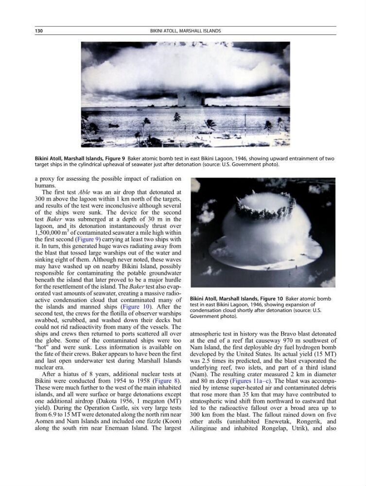
lagoon, and its detonation instantaneously thrust over
1,500,000 m
3 of contaminated seawater a mile high within
the first second (Figure 9) carrying at least two ships with
it. In turn, this generated huge waves radiating away from
the blast that tossed large warships out of the water and
sinking eight of them. Although never noted, these waves
may have washed up on nearby Bikini Island, possibly
responsible for contaminating the potable groundwater
beneath the island that later proved to be a major hurdle
for the resettlement of the island. The Baker test also evaporated vast amounts of seawater, creating a massive radioactive condensation cloud that contaminated many of
the islands and manned ships (Figure 10). After the
second test, the crews for the flotilla of observer warships
swabbed, scrubbed, and washed down their decks but
could not rid radioactivity from many of the vessels. The
ships and crews then returned to ports scattered all over
the globe. Some of the contaminated ships were too
“hot” and were sunk. Less information is available on
the fate of their crews. Baker appears to have been the first
and last open underwater test during Marshall Islands
nuclear era.
After a hiatus of 8 years, additional nuclear tests at
Bikini were conducted from 1954 to 1958 (Figure 8).
These were much further to the west of the main inhabited
islands, and all were surface or barge detonations except
one additional airdrop (Dakota 1956, 1 megaton (MT)
yield). During the Operation Castle, six very large tests
from 6.9 to 15 MT were detonated along the north rim near
Aomen and Nam Islands and included one fizzle (Koon)
along the south rim near Enemaan Island. The largest
atmospheric test in history was the Bravo blast detonated
at the end of a reef flat causeway 970 m southwest of
Nam Island, the first deployable dry fuel hydrogen bomb
developed by the United States. Its actual yield (15 MT)
was 2.5 times its predicted, and the blast evaporated the
underlying reef, two islets, and part of a third island
(Nam). The resulting crater measured 2 km in diameter
and 80 m deep (Figures 11a–c). The blast was accompanied by intense super-heated air and contaminated debris
that rose more than 35 km that may have contributed to
stratospheric wind shift from northward to eastward that
led to the radioactive fallout over a broad area up to
300 km from the blast. The fallout rained down on five
other atolls (uninhabited Enewetak, Rongerik, and
Ailinginae and inhabited Rongelap, Utrik), and also
Bikini Atoll, Marshall Islands, Figure 9 Baker atomic bomb test in east Bikini Lagoon, 1946, showing upward entrainment of two
target ships in the cylindrical upheaval of seawater just after detonation (source: U.S. Government photo).
Bikini Atoll, Marshall Islands, Figure 10 Baker atomic bomb
test in east Bikini Lagoon, 1946, showing expansion of
condensation cloud shortly after detonation (source: U.S.
Government photo).
130
BIKINI ATOLL, MARSHALL ISLANDS
humans.
The first test Able was an air drop that detonated at
300 m above the lagoon within 1 km north of the targets,
and results of the test were inconclusive although several
of the ships were sunk. The device for the second
test Baker was submerged at a depth of 30 m in the
lagoon, and its detonation instantaneously thrust over
1,500,000 m
3 of contaminated seawater a mile high within
the first second (Figure 9) carrying at least two ships with
it. In turn, this generated huge waves radiating away from
the blast that tossed large warships out of the water and
sinking eight of them. Although never noted, these waves
may have washed up on nearby Bikini Island, possibly
responsible for contaminating the potable groundwater
beneath the island that later proved to be a major hurdle
for the resettlement of the island. The Baker test also evaporated vast amounts of seawater, creating a massive radioactive condensation cloud that contaminated many of
the islands and manned ships (Figure 10). After the
second test, the crews for the flotilla of observer warships
swabbed, scrubbed, and washed down their decks but
could not rid radioactivity from many of the vessels. The
ships and crews then returned to ports scattered all over
the globe. Some of the contaminated ships were too
“hot” and were sunk. Less information is available on
the fate of their crews. Baker appears to have been the first
and last open underwater test during Marshall Islands
nuclear era.
After a hiatus of 8 years, additional nuclear tests at
Bikini were conducted from 1954 to 1958 (Figure 8).
These were much further to the west of the main inhabited
islands, and all were surface or barge detonations except
one additional airdrop (Dakota 1956, 1 megaton (MT)
yield). During the Operation Castle, six very large tests
from 6.9 to 15 MT were detonated along the north rim near
Aomen and Nam Islands and included one fizzle (Koon)
along the south rim near Enemaan Island. The largest
atmospheric test in history was the Bravo blast detonated
at the end of a reef flat causeway 970 m southwest of
Nam Island, the first deployable dry fuel hydrogen bomb
developed by the United States. Its actual yield (15 MT)
was 2.5 times its predicted, and the blast evaporated the
underlying reef, two islets, and part of a third island
(Nam). The resulting crater measured 2 km in diameter
and 80 m deep (Figures 11a–c). The blast was accompanied by intense super-heated air and contaminated debris
that rose more than 35 km that may have contributed to
stratospheric wind shift from northward to eastward that
led to the radioactive fallout over a broad area up to
300 km from the blast. The fallout rained down on five
other atolls (uninhabited Enewetak, Rongerik, and
Ailinginae and inhabited Rongelap, Utrik), and also
Bikini Atoll, Marshall Islands, Figure 9 Baker atomic bomb test in east Bikini Lagoon, 1946, showing upward entrainment of two
target ships in the cylindrical upheaval of seawater just after detonation (source: U.S. Government photo).
Bikini Atoll, Marshall Islands, Figure 10 Baker atomic bomb
test in east Bikini Lagoon, 1946, showing expansion of
condensation cloud shortly after detonation (source: U.S.
Government photo).
130
BIKINI ATOLL, MARSHALL ISLANDS