

other payloads including conductivity, temperature, and
depth (CTD), acoustic Doppler current profilers (ADCPs),
sidescan and multibeam sonars, and more specialized payloads like plankton samplers (Kirkwood, 1998) and microelectrodes for porewater studies (Luther et al., 1999).
ROVs are most often deployed from a surface ship, and
operated a short lateral distance away from the ship.
Deep-water deployments may require the surface ship to
station-keep using dynamic positioning. Because tether
management is a complex task, ROVs are best suited for
exploring relatively small (hundreds of square meters),
targeted areas of the seafloor, rather than conducting
large-area surveys. Geopositioning of the ROV is provided by acoustic means (UltraShort BaseLine – USBL,
or Short BaseLine – SBL) relative to the surface ship’s
position.
AUV technology
AUVs are free-swimming robots that can gather data with
enough spatial and/or temporal resolution to reduce data
aliasing (ORION, 2004). Most are torpedo shaped to
reduce drag, contrasted with the box-like shape of ROVs,
where drag minimization makes little sense given the
already high drag of the ROV’s tether. AUVs range in
length from 1.5 to 5.5 m, with weight in air 20–1,400 kg.
AUVs are slightly positively buoyant or have drop weights
to produce positive buoyancy at the end of the mission. This
ensures the AUV will surface even if onboard control systems have failed. AUVs are battery powered; small AUVs
can deploy for several hours, while large vehicles can swim
for several days. Survey speeds are usually 1–2 m/s, chosen
to maximize range for the onboard battery power. Depth
ranges are comparable to ROVs, with many vehicles capable of surveying to continental shelf depths, with few
capable of full-ocean depth.
AUVs are well suited to Swathe Mapping and largearea surveys. AUVs carry multiple payloads, allowing
synoptic coverage; for example, an AUV may simultaneously image the seafloor while measuring water quality.
In addition to the payloads listed above for ROVs, AUVs
routinely carry fluorometers, turbidity and turbulence
sensors, magnetometers, and water quality sensors
(Hayes et al., 2007; Nicholson and Healey, 2008). AUV
position underwater can be determined using acoustic
positioning relative to a surface vessel or subsea transponders, or by dead reckoning using a Doppler velocity
log to measure speed over the bottom and direction using
a compass, or by inertial navigation whereby the accelerations and rotations of the AUV are measured and equations of motion solved. Some AUVs may blend
information from several navigational methods to obtain
the highest possible accuracy using a nonlinear predictor–corrector algorithm called a Kalman filter (overview
of AUV navigation available at http://www.ise.bc.ca/
WADEnavandpos.html).
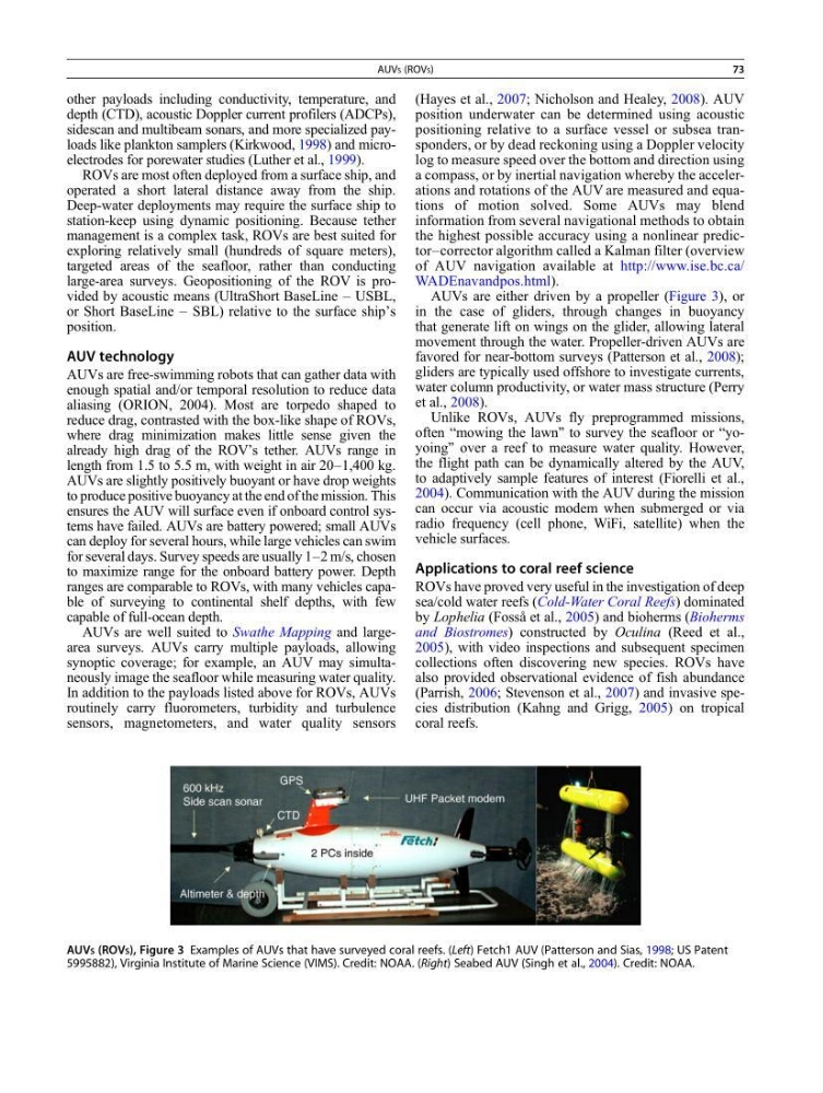
AUVs are either driven by a propeller (Figure 3), or
in the case of gliders, through changes in buoyancy
that generate lift on wings on the glider, allowing lateral
movement through the water. Propeller-driven AUVs are
favored for near-bottom surveys (Patterson et al., 2008);
gliders are typically used offshore to investigate currents,
water column productivity, or water mass structure (Perry
et al., 2008).
Unlike ROVs, AUVs fly preprogrammed missions,
often “mowing the lawn” to survey the seafloor or “yoyoing” over a reef to measure water quality. However,
the flight path can be dynamically altered by the AUV,
to adaptively sample features of interest (Fiorelli et al.,
2004). Communication with the AUV during the mission
can occur via acoustic modem when submerged or via
radio frequency (cell phone, WiFi, satellite) when the
vehicle surfaces.
Applications to coral reef science
ROVs have proved very useful in the investigation of deep
sea/cold water reefs (Cold-Water Coral Reefs) dominated
by Lophelia (Fosså et al., 2005) and bioherms (Bioherms
and Biostromes) constructed by Oculina (Reed et al.,
2005), with video inspections and subsequent specimen
collections often discovering new species. ROVs have
also provided observational evidence of fish abundance
(Parrish, 2006; Stevenson et al., 2007) and invasive species distribution (Kahng and Grigg, 2005) on tropical
coral reefs.
AUVS (ROVS), Figure 3 Examples of AUVs that have surveyed coral reefs. (Left) Fetch1 AUV (Patterson and Sias, 1998; US Patent
5995882), Virginia Institute of Marine Science (VIMS). Credit: NOAA. (Right) Seabed AUV (Singh et al., 2004). Credit: NOAA.
AUVS (ROVS)
73
depth (CTD), acoustic Doppler current profilers (ADCPs),
sidescan and multibeam sonars, and more specialized payloads like plankton samplers (Kirkwood, 1998) and microelectrodes for porewater studies (Luther et al., 1999).
ROVs are most often deployed from a surface ship, and
operated a short lateral distance away from the ship.
Deep-water deployments may require the surface ship to
station-keep using dynamic positioning. Because tether
management is a complex task, ROVs are best suited for
exploring relatively small (hundreds of square meters),
targeted areas of the seafloor, rather than conducting
large-area surveys. Geopositioning of the ROV is provided by acoustic means (UltraShort BaseLine – USBL,
or Short BaseLine – SBL) relative to the surface ship’s
position.
AUV technology
AUVs are free-swimming robots that can gather data with
enough spatial and/or temporal resolution to reduce data
aliasing (ORION, 2004). Most are torpedo shaped to
reduce drag, contrasted with the box-like shape of ROVs,
where drag minimization makes little sense given the
already high drag of the ROV’s tether. AUVs range in
length from 1.5 to 5.5 m, with weight in air 20–1,400 kg.
AUVs are slightly positively buoyant or have drop weights
to produce positive buoyancy at the end of the mission. This
ensures the AUV will surface even if onboard control systems have failed. AUVs are battery powered; small AUVs
can deploy for several hours, while large vehicles can swim
for several days. Survey speeds are usually 1–2 m/s, chosen
to maximize range for the onboard battery power. Depth
ranges are comparable to ROVs, with many vehicles capable of surveying to continental shelf depths, with few
capable of full-ocean depth.
AUVs are well suited to Swathe Mapping and largearea surveys. AUVs carry multiple payloads, allowing
synoptic coverage; for example, an AUV may simultaneously image the seafloor while measuring water quality.
In addition to the payloads listed above for ROVs, AUVs
routinely carry fluorometers, turbidity and turbulence
sensors, magnetometers, and water quality sensors
(Hayes et al., 2007; Nicholson and Healey, 2008). AUV
position underwater can be determined using acoustic
positioning relative to a surface vessel or subsea transponders, or by dead reckoning using a Doppler velocity
log to measure speed over the bottom and direction using
a compass, or by inertial navigation whereby the accelerations and rotations of the AUV are measured and equations of motion solved. Some AUVs may blend
information from several navigational methods to obtain
the highest possible accuracy using a nonlinear predictor–corrector algorithm called a Kalman filter (overview
of AUV navigation available at http://www.ise.bc.ca/
WADEnavandpos.html).
AUVs are either driven by a propeller (Figure 3), or
in the case of gliders, through changes in buoyancy
that generate lift on wings on the glider, allowing lateral
movement through the water. Propeller-driven AUVs are
favored for near-bottom surveys (Patterson et al., 2008);
gliders are typically used offshore to investigate currents,
water column productivity, or water mass structure (Perry
et al., 2008).
Unlike ROVs, AUVs fly preprogrammed missions,
often “mowing the lawn” to survey the seafloor or “yoyoing” over a reef to measure water quality. However,
the flight path can be dynamically altered by the AUV,
to adaptively sample features of interest (Fiorelli et al.,
2004). Communication with the AUV during the mission
can occur via acoustic modem when submerged or via
radio frequency (cell phone, WiFi, satellite) when the
vehicle surfaces.
Applications to coral reef science
ROVs have proved very useful in the investigation of deep
sea/cold water reefs (Cold-Water Coral Reefs) dominated
by Lophelia (Fosså et al., 2005) and bioherms (Bioherms
and Biostromes) constructed by Oculina (Reed et al.,
2005), with video inspections and subsequent specimen
collections often discovering new species. ROVs have
also provided observational evidence of fish abundance
(Parrish, 2006; Stevenson et al., 2007) and invasive species distribution (Kahng and Grigg, 2005) on tropical
coral reefs.
AUVS (ROVS), Figure 3 Examples of AUVs that have surveyed coral reefs. (Left) Fetch1 AUV (Patterson and Sias, 1998; US Patent
5995882), Virginia Institute of Marine Science (VIMS). Credit: NOAA. (Right) Seabed AUV (Singh et al., 2004). Credit: NOAA.
AUVS (ROVS)
73