

AUVs have mapped currents and bathymetry of coral
reefs over large areas in deep water (Grasmueck et al.,
2006), and made detailed photomosaics in shallower
water (Armstrong et al., 2006). The physical oceanography of tropical coral reefs has also been surveyed by
AUVs, including currents (Fong and Jones, 2006), plume
dispersion (Jones et al., 2008), and hydrography and
bathymetry (Shcherbina et al., 2008). AUVs are also
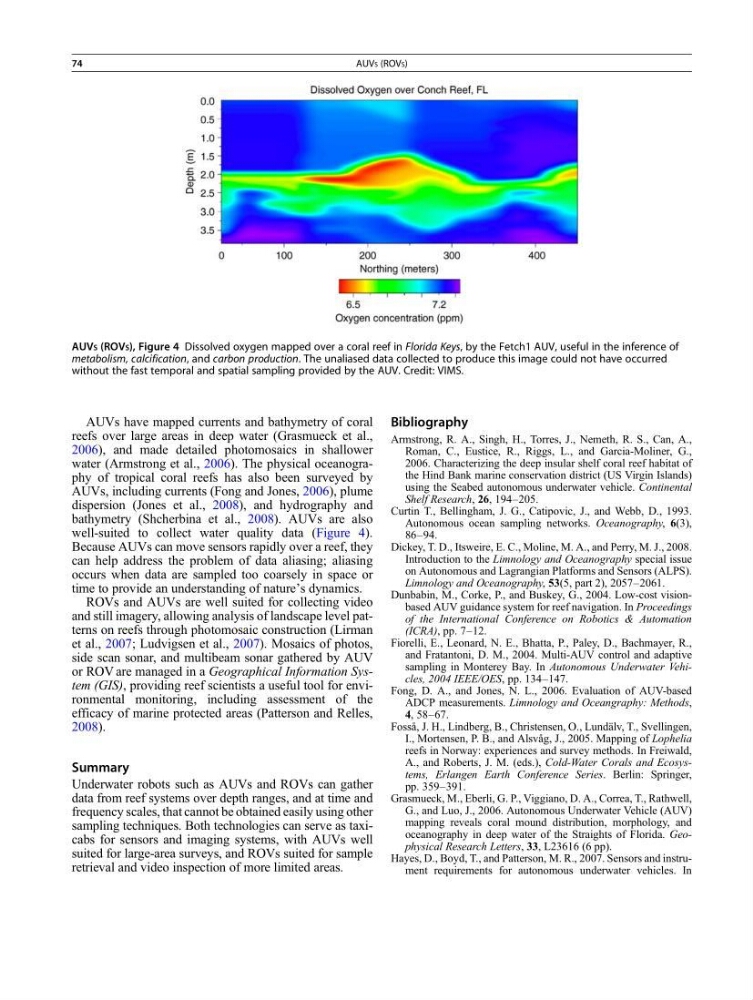
well-suited to collect water quality data (Figure 4).
Because AUVs can move sensors rapidly over a reef, they
can help address the problem of data aliasing; aliasing
occurs when data are sampled too coarsely in space or
time to provide an understanding of nature’s dynamics.
ROVs and AUVs are well suited for collecting video
and still imagery, allowing analysis of landscape level patterns on reefs through photomosaic construction (Lirman
et al., 2007; Ludvigsen et al., 2007). Mosaics of photos,
side scan sonar, and multibeam sonar gathered by AUV
or ROV are managed in a Geographical Information System (GIS), providing reef scientists a useful tool for environmental monitoring, including assessment of the
efficacy of marine protected areas (Patterson and Relles,
2008).
Summary
Underwater robots such as AUVs and ROVs can gather
data from reef systems over depth ranges, and at time and
frequency scales, that cannot be obtained easily using other
sampling techniques. Both technologies can serve as taxicabs for sensors and imaging systems, with AUVs well
suited for large-area surveys, and ROVs suited for sample
retrieval and video inspection of more limited areas.
Bibliography
Armstrong, R. A., Singh, H., Torres, J., Nemeth, R. S., Can, A.,
Roman, C., Eustice, R., Riggs, L., and Garcia-Moliner, G.,
2006. Characterizing the deep insular shelf coral reef habitat of
the Hind Bank marine conservation district (US Virgin Islands)
using the Seabed autonomous underwater vehicle. Continental
Shelf Research, 26, 194–205.
Curtin T., Bellingham, J. G., Catipovic, J., and Webb, D., 1993.
Autonomous ocean sampling networks. Oceanography, 6(3),
86–94.
Dickey, T. D., Itsweire, E. C., Moline, M. A., and Perry, M. J., 2008.
Introduction to the Limnology and Oceanography special issue
on Autonomous and Lagrangian Platforms and Sensors (ALPS).
Limnology and Oceanography, 53(5, part 2), 2057–2061.
Dunbabin, M., Corke, P., and Buskey, G., 2004. Low-cost visionbased AUV guidance system for reef navigation. In Proceedings
of the International Conference on Robotics & Automation
(ICRA), pp. 7–12.
Fiorelli, E., Leonard, N. E., Bhatta, P., Paley, D., Bachmayer, R.,
and Fratantoni, D. M., 2004. Multi-AUV control and adaptive
sampling in Monterey Bay. In Autonomous Underwater Vehicles, 2004 IEEE/OES, pp. 134–147.
Fong, D. A., and Jones, N. L., 2006. Evaluation of AUV-based
ADCP measurements. Limnology and Oceangraphy: Methods,
4, 58–67.
Fosså, J. H., Lindberg, B., Christensen, O., Lundälv, T., Svellingen,
I., Mortensen, P. B., and Alsvåg, J., 2005. Mapping of Lophelia
reefs in Norway: experiences and survey methods. In Freiwald,
A., and Roberts, J. M. (eds.), Cold-Water Corals and Ecosystems, Erlangen Earth Conference Series. Berlin: Springer,
pp. 359–391.
Grasmueck, M., Eberli, G. P., Viggiano, D. A., Correa, T., Rathwell,
G., and Luo, J., 2006. Autonomous Underwater Vehicle (AUV)
mapping reveals coral mound distribution, morphology, and
oceanography in deep water of the Straights of Florida. Geophysical Research Letters, 33, L23616 (6 pp).
Hayes, D., Boyd, T., and Patterson, M. R., 2007. Sensors and instrument requirements for autonomous underwater vehicles. In
AUVS (ROVS), Figure 4 Dissolved oxygen mapped over a coral reef in Florida Keys, by the Fetch1 AUV, useful in the inference of
metabolism, calcification, and carbon production. The unaliased data collected to produce this image could not have occurred
without the fast temporal and spatial sampling provided by the AUV. Credit: VIMS.
74
AUVS (ROVS)
reefs over large areas in deep water (Grasmueck et al.,
2006), and made detailed photomosaics in shallower
water (Armstrong et al., 2006). The physical oceanography of tropical coral reefs has also been surveyed by
AUVs, including currents (Fong and Jones, 2006), plume
dispersion (Jones et al., 2008), and hydrography and
bathymetry (Shcherbina et al., 2008). AUVs are also
well-suited to collect water quality data (Figure 4).
Because AUVs can move sensors rapidly over a reef, they
can help address the problem of data aliasing; aliasing
occurs when data are sampled too coarsely in space or
time to provide an understanding of nature’s dynamics.
ROVs and AUVs are well suited for collecting video
and still imagery, allowing analysis of landscape level patterns on reefs through photomosaic construction (Lirman
et al., 2007; Ludvigsen et al., 2007). Mosaics of photos,
side scan sonar, and multibeam sonar gathered by AUV
or ROV are managed in a Geographical Information System (GIS), providing reef scientists a useful tool for environmental monitoring, including assessment of the
efficacy of marine protected areas (Patterson and Relles,
2008).
Summary
Underwater robots such as AUVs and ROVs can gather
data from reef systems over depth ranges, and at time and
frequency scales, that cannot be obtained easily using other
sampling techniques. Both technologies can serve as taxicabs for sensors and imaging systems, with AUVs well
suited for large-area surveys, and ROVs suited for sample
retrieval and video inspection of more limited areas.
Bibliography
Armstrong, R. A., Singh, H., Torres, J., Nemeth, R. S., Can, A.,
Roman, C., Eustice, R., Riggs, L., and Garcia-Moliner, G.,
2006. Characterizing the deep insular shelf coral reef habitat of
the Hind Bank marine conservation district (US Virgin Islands)
using the Seabed autonomous underwater vehicle. Continental
Shelf Research, 26, 194–205.
Curtin T., Bellingham, J. G., Catipovic, J., and Webb, D., 1993.
Autonomous ocean sampling networks. Oceanography, 6(3),
86–94.
Dickey, T. D., Itsweire, E. C., Moline, M. A., and Perry, M. J., 2008.
Introduction to the Limnology and Oceanography special issue
on Autonomous and Lagrangian Platforms and Sensors (ALPS).
Limnology and Oceanography, 53(5, part 2), 2057–2061.
Dunbabin, M., Corke, P., and Buskey, G., 2004. Low-cost visionbased AUV guidance system for reef navigation. In Proceedings
of the International Conference on Robotics & Automation
(ICRA), pp. 7–12.
Fiorelli, E., Leonard, N. E., Bhatta, P., Paley, D., Bachmayer, R.,
and Fratantoni, D. M., 2004. Multi-AUV control and adaptive
sampling in Monterey Bay. In Autonomous Underwater Vehicles, 2004 IEEE/OES, pp. 134–147.
Fong, D. A., and Jones, N. L., 2006. Evaluation of AUV-based
ADCP measurements. Limnology and Oceangraphy: Methods,
4, 58–67.
Fosså, J. H., Lindberg, B., Christensen, O., Lundälv, T., Svellingen,
I., Mortensen, P. B., and Alsvåg, J., 2005. Mapping of Lophelia
reefs in Norway: experiences and survey methods. In Freiwald,
A., and Roberts, J. M. (eds.), Cold-Water Corals and Ecosystems, Erlangen Earth Conference Series. Berlin: Springer,
pp. 359–391.
Grasmueck, M., Eberli, G. P., Viggiano, D. A., Correa, T., Rathwell,
G., and Luo, J., 2006. Autonomous Underwater Vehicle (AUV)
mapping reveals coral mound distribution, morphology, and
oceanography in deep water of the Straights of Florida. Geophysical Research Letters, 33, L23616 (6 pp).
Hayes, D., Boyd, T., and Patterson, M. R., 2007. Sensors and instrument requirements for autonomous underwater vehicles. In
AUVS (ROVS), Figure 4 Dissolved oxygen mapped over a coral reef in Florida Keys, by the Fetch1 AUV, useful in the inference of
metabolism, calcification, and carbon production. The unaliased data collected to produce this image could not have occurred
without the fast temporal and spatial sampling provided by the AUV. Credit: VIMS.
74
AUVS (ROVS)