

and stream valleys were incised into coastal terrain. When
sea level returned and flooded these valleys to create estuaries, mixing-zone dissolution resulted in flank margin
cave development along the carbonate estuary periphery.
In tectonic islands, uplift carried these estuaries above
sea level. On Barbados, that uplift has lifted these paleoestuaries above any possible glacioeustatic sea-level
highstand position, and the valleys have been reoccupied
by fluvial processes. These valleys are called gullies
locally and have been previously interpreted to be collapsed stream caves because of open cave chambers and
exposed speleothems (stalagmites, stalactites and flowstone, etc.) found on the gully walls (Machel, 1999).
These caves have been reinterpreted as flank margin caves
(Figure 6), now exposed by scarp and slope retreat
(Kambesis and Machel, 2013). The caves fit the morphological pattern of flank margin caves and lack evidence
of development by turbulent water flow (as stream caves
would display), and the gullies containing these cave fragments are wider than any known stream caves on Barbados (e.g., Harrisons Cave or Coles Cave, each over 1 km
long). In other words, if the gullies were collapsed stream
caves, the scarp and slope retreat necessary to give the
gullies their current width should have removed all evidence of the initial stream cave, including speleothems.
Similar flank margin cave patterns can be found in the
bokas of Curaçao (Kambesis et al., in press) and the calas
of Mallorca (Mylroie et al., in press), rock-walled coastal
reentrants that lead landward to in-feeding fluvial systems
(Figure 6). The caletas of the Yucatan (Figure 7) represent
a variation of karst reentrant produced by conduit-flow
stream caves entering the coastal environment
(Kambesis and Coke, 2013).
When an estuary has been uplifted beyond current and
past sea-level positions, erosional processes can remove
surficial marine deposits and weathering features (such as
wave cut notches) that would otherwise allow these valleys
to be identified as paleo-estuaries. The existence of flank
margin caves on the periphery of these valleys indicates that
they once held a marine water body, which helped drive
mixing-zone dissolution. The same slope and scarp erosion
that removed the surficial marine signature has opened the
caves that developed under the flank of the land, allowing
a more accurate interpretation of the valley’s history as an
estuary to be determined. In this manner, paleo-estuaries,
especially those associated with the rapid sea-level fluctuations of the Quaternary, can be recognized when traditional
evidence has been eroded away.
Soluble rock as an estuary coastal aquifer
The discharge of aquifers into estuaries has been called the
subterranean estuary (Moore, 1999), where chemical reactions between marine water and aquifer material alter the
composition of the discharging water. In addition to the
mixing-zone dissolution previously discussed, the mixing
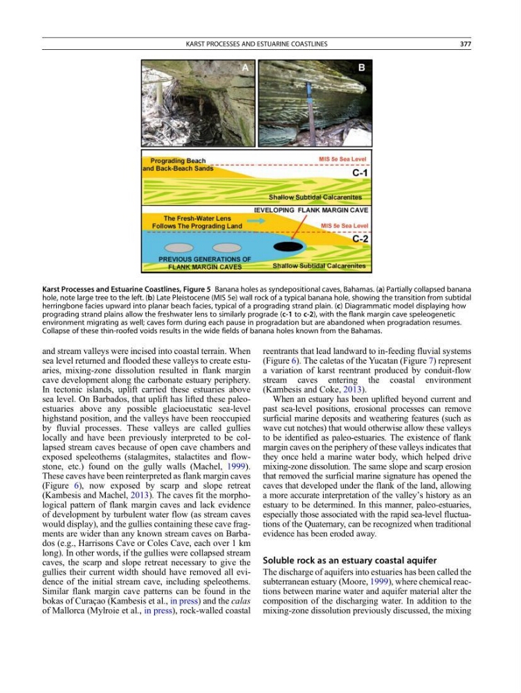
Karst Processes and Estuarine Coastlines, Figure 5 Banana holes as syndepositional caves, Bahamas. (a) Partially collapsed banana
hole, note large tree to the left. (b) Late Pleistocene (MIS 5e) wall rock of a typical banana hole, showing the transition from subtidal
herringbone facies upward into planar beach facies, typical of a prograding strand plain. (c) Diagrammatic model displaying how
prograding strand plains allow the freshwater lens to similarly prograde (c-1 to c-2), with the flank margin cave speleogenetic
environment migrating as well; caves form during each pause in progradation but are abandoned when progradation resumes.
Collapse of these thin-roofed voids results in the wide fields of banana holes known from the Bahamas.
KARST PROCESSES AND ESTUARINE COASTLINES
377
sea level returned and flooded these valleys to create estuaries, mixing-zone dissolution resulted in flank margin
cave development along the carbonate estuary periphery.
In tectonic islands, uplift carried these estuaries above
sea level. On Barbados, that uplift has lifted these paleoestuaries above any possible glacioeustatic sea-level
highstand position, and the valleys have been reoccupied
by fluvial processes. These valleys are called gullies
locally and have been previously interpreted to be collapsed stream caves because of open cave chambers and
exposed speleothems (stalagmites, stalactites and flowstone, etc.) found on the gully walls (Machel, 1999).
These caves have been reinterpreted as flank margin caves
(Figure 6), now exposed by scarp and slope retreat
(Kambesis and Machel, 2013). The caves fit the morphological pattern of flank margin caves and lack evidence
of development by turbulent water flow (as stream caves
would display), and the gullies containing these cave fragments are wider than any known stream caves on Barbados (e.g., Harrisons Cave or Coles Cave, each over 1 km
long). In other words, if the gullies were collapsed stream
caves, the scarp and slope retreat necessary to give the
gullies their current width should have removed all evidence of the initial stream cave, including speleothems.
Similar flank margin cave patterns can be found in the
bokas of Curaçao (Kambesis et al., in press) and the calas
of Mallorca (Mylroie et al., in press), rock-walled coastal
reentrants that lead landward to in-feeding fluvial systems
(Figure 6). The caletas of the Yucatan (Figure 7) represent
a variation of karst reentrant produced by conduit-flow
stream caves entering the coastal environment
(Kambesis and Coke, 2013).
When an estuary has been uplifted beyond current and
past sea-level positions, erosional processes can remove
surficial marine deposits and weathering features (such as
wave cut notches) that would otherwise allow these valleys
to be identified as paleo-estuaries. The existence of flank
margin caves on the periphery of these valleys indicates that
they once held a marine water body, which helped drive
mixing-zone dissolution. The same slope and scarp erosion
that removed the surficial marine signature has opened the
caves that developed under the flank of the land, allowing
a more accurate interpretation of the valley’s history as an
estuary to be determined. In this manner, paleo-estuaries,
especially those associated with the rapid sea-level fluctuations of the Quaternary, can be recognized when traditional
evidence has been eroded away.
Soluble rock as an estuary coastal aquifer
The discharge of aquifers into estuaries has been called the
subterranean estuary (Moore, 1999), where chemical reactions between marine water and aquifer material alter the
composition of the discharging water. In addition to the
mixing-zone dissolution previously discussed, the mixing
Karst Processes and Estuarine Coastlines, Figure 5 Banana holes as syndepositional caves, Bahamas. (a) Partially collapsed banana
hole, note large tree to the left. (b) Late Pleistocene (MIS 5e) wall rock of a typical banana hole, showing the transition from subtidal
herringbone facies upward into planar beach facies, typical of a prograding strand plain. (c) Diagrammatic model displaying how
prograding strand plains allow the freshwater lens to similarly prograde (c-1 to c-2), with the flank margin cave speleogenetic
environment migrating as well; caves form during each pause in progradation but are abandoned when progradation resumes.
Collapse of these thin-roofed voids results in the wide fields of banana holes known from the Bahamas.
KARST PROCESSES AND ESTUARINE COASTLINES
377