

a shorter route to an adjacent embayment rather than continuing as diffuse flow to a distant coast. Mixing dissolution is focused along the periphery of the estuary, with
a consequent appearance and growth of flank margin
caves.
Where estuary coastlines are rocky and cliffed, sea or
littoral cave development can occur in any lithology
strong enough to support cliff development (Waterstrat
et al., 2010). Sea caves form primarily by mechanical
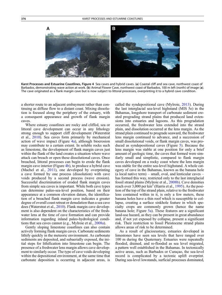
action of wave impact (Figure 4a), although bioerosion
may contribute to a certain extent. In soluble rocks such
as limestone, the development of flank margin caves just
within the flank of the land creates a situation where wave
attack can breach or open these dissolutional caves. Once
breached, littoral processes can begin to erode the flank
margin cave interior (Figure 4b), to produce a hybrid cave
(Machel et al., 2011), one developed by overprinting
a cave formed by one process (dissolution) with cave
voids produced by a second process (wave erosion).
Successful discrimination of eroded flank margin caves
from simple sea caves is important. While both cave types
can determine paleo-sea-level position, based on their
appearance at a common elevation datum, the identification of a breached flank margin cave indicates a greater
degree of overall coast retreat or denudation than a sea cave
does (Waterstrat et al., 2010). Flank margin cave development is also dependent on the characteristics of the freshwater lens at the time of cave formation and can provide
information regarding inland paleo-hydrological conditions that sea caves cannot (e.g., Mylroie et al., 2008a).
Gently sloping limestone coastlines can also contain
actively forming flank margin caves. Carbonate sediments
lithify quickly in the meteoric environment. As carbonate
sediments are deposited, and subaerially exposed, the initial steps for lithification into limestone can begin. The
presence of a freshwater lens margin allows cave development to similarly occur. The type of cave voids developing
within the depositional environment, at the same time that
carbonate deposition is occurring in adjacent areas, is
called the syndepositional cave (Mylroie, 2013). During
the last interglacial sea-level highstand (MIS 5e) in the
Bahamas, longshore transport of carbonate sediment created prograding strand plains that produced land extensions into estuaries and lagoons. As this progradation
occurred, the freshwater lens extended into the strand
plain, and dissolution occurred at the lens margin. As the
strand plain continued to prograde seaward, the freshwater
lens margin continued to advance, and a succession of
small dissolutional voids, or flank margin caves, was produced as syndepositional caves (Figure 5). Because the
lens margin was stable at one position for only a brief
amount of geologic time, the caves that formed were similarly small and simplistic, compared to flank margin
caves developed on a rocky coast where the lens margin
was stable for the entire sea-level highstand. A whole category of cave in the Bahamas, known as the banana hole
(a local native term) – small, oval, and lenticular caves –
has formed this way, restricted only to the last interglacial
fossil strand plains (Mylroie et al., 2008b). Cave densities
reach over 3,000 per km
2 (Harris et al., 1995). As the position of the top of the strand plain, relative to the freshwater
lens contained within in it, is only a few meters, these
banana holes have a thin roof which is susceptible to collapse, creating a surface sinkhole feature in which specialty crops are commonly grown (hence the name
banana hole; Figure 5a). These features are a significant
land-use hazard, as they can be present in great abundance
and, if not yet exposed by collapse, present a significant
risk. Their restriction to fossil Pleistocene strand plains
allows areas of risk to be determined.
As a result of glacioeustasy, estuaries developed in
limestones have seen sea levels that have ranged over
100 m during the Quaternary. Estuaries were repeatedly
flooded, drained, and re-flooded as sea level migrated,
a pattern well established in the Bahamas. In tectonically
active areas, such as Barbados or Curaçao, the sea-level
record is complicated by a tectonic uplift overprint.
During sea-level lowstands, surficial processes dominated,
Karst Processes and Estuarine Coastlines, Figure 4 Sea caves and hybrid caves. (a) Coastal cliff and sea cave, northwest coast of
Barbados, demonstrating wave action at work. (b) Animal Flower Cave, northwest coast of Barbados, 100 m left (north) of image (a).
The cave originated as a flank margin cave but is now subject to littoral processes, overprinting it to a hybrid cave condition.
376
KARST PROCESSES AND ESTUARINE COASTLINES
a consequent appearance and growth of flank margin
caves.
Where estuary coastlines are rocky and cliffed, sea or
littoral cave development can occur in any lithology
strong enough to support cliff development (Waterstrat
et al., 2010). Sea caves form primarily by mechanical
action of wave impact (Figure 4a), although bioerosion
may contribute to a certain extent. In soluble rocks such
as limestone, the development of flank margin caves just
within the flank of the land creates a situation where wave
attack can breach or open these dissolutional caves. Once
breached, littoral processes can begin to erode the flank
margin cave interior (Figure 4b), to produce a hybrid cave
(Machel et al., 2011), one developed by overprinting
a cave formed by one process (dissolution) with cave
voids produced by a second process (wave erosion).
Successful discrimination of eroded flank margin caves
from simple sea caves is important. While both cave types
can determine paleo-sea-level position, based on their
appearance at a common elevation datum, the identification of a breached flank margin cave indicates a greater
degree of overall coast retreat or denudation than a sea cave
does (Waterstrat et al., 2010). Flank margin cave development is also dependent on the characteristics of the freshwater lens at the time of cave formation and can provide
information regarding inland paleo-hydrological conditions that sea caves cannot (e.g., Mylroie et al., 2008a).
Gently sloping limestone coastlines can also contain
actively forming flank margin caves. Carbonate sediments
lithify quickly in the meteoric environment. As carbonate
sediments are deposited, and subaerially exposed, the initial steps for lithification into limestone can begin. The
presence of a freshwater lens margin allows cave development to similarly occur. The type of cave voids developing
within the depositional environment, at the same time that
carbonate deposition is occurring in adjacent areas, is
called the syndepositional cave (Mylroie, 2013). During
the last interglacial sea-level highstand (MIS 5e) in the
Bahamas, longshore transport of carbonate sediment created prograding strand plains that produced land extensions into estuaries and lagoons. As this progradation
occurred, the freshwater lens extended into the strand
plain, and dissolution occurred at the lens margin. As the
strand plain continued to prograde seaward, the freshwater
lens margin continued to advance, and a succession of
small dissolutional voids, or flank margin caves, was produced as syndepositional caves (Figure 5). Because the
lens margin was stable at one position for only a brief
amount of geologic time, the caves that formed were similarly small and simplistic, compared to flank margin
caves developed on a rocky coast where the lens margin
was stable for the entire sea-level highstand. A whole category of cave in the Bahamas, known as the banana hole
(a local native term) – small, oval, and lenticular caves –
has formed this way, restricted only to the last interglacial
fossil strand plains (Mylroie et al., 2008b). Cave densities
reach over 3,000 per km
2 (Harris et al., 1995). As the position of the top of the strand plain, relative to the freshwater
lens contained within in it, is only a few meters, these
banana holes have a thin roof which is susceptible to collapse, creating a surface sinkhole feature in which specialty crops are commonly grown (hence the name
banana hole; Figure 5a). These features are a significant
land-use hazard, as they can be present in great abundance
and, if not yet exposed by collapse, present a significant
risk. Their restriction to fossil Pleistocene strand plains
allows areas of risk to be determined.
As a result of glacioeustasy, estuaries developed in
limestones have seen sea levels that have ranged over
100 m during the Quaternary. Estuaries were repeatedly
flooded, drained, and re-flooded as sea level migrated,
a pattern well established in the Bahamas. In tectonically
active areas, such as Barbados or Curaçao, the sea-level
record is complicated by a tectonic uplift overprint.
During sea-level lowstands, surficial processes dominated,
Karst Processes and Estuarine Coastlines, Figure 4 Sea caves and hybrid caves. (a) Coastal cliff and sea cave, northwest coast of
Barbados, demonstrating wave action at work. (b) Animal Flower Cave, northwest coast of Barbados, 100 m left (north) of image (a).
The cave originated as a flank margin cave but is now subject to littoral processes, overprinting it to a hybrid cave condition.
376
KARST PROCESSES AND ESTUARINE COASTLINES