

divergent flows, and horn convergent flows will develop,
and under high-energy conditions, sweeping flows and
swash-jet flows can occur (Masselink et al., 1998).
Beach ridges
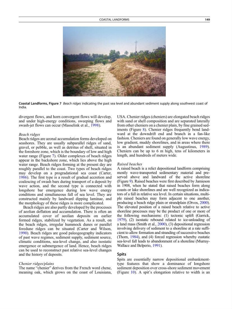
Beach ridges are azonal accumulation forms developed on
seashores. They are usually subparallel ridges of sand,
gravel, or pebble, as well as detritus of shell, situated in
the foreshore zone, which is the boundary of low and high
water range (Figure 7). Older complexes of beach ridges
appear in the backshore zone, which lies above the high
water range. Beach ridges forming at the present day are
roughly parallel to the coast. Two types of beach ridges
may develop on a progradational sea coast (Carter,
1986). The first type is a result of gradual accretion and
coalescing of swash bars during transport of a deposit by
wave action, and the second type is connected with
longshore bar emergence during low wave energy
conditions and simultaneous fall of sea level. They are
constructed mainly by landward dipping laminae, and
the morphology of these ridges is more complicated.
Beach ridges are also partly developed by the processes
of aeolian deflation and accumulation. There is often an
accumulated cover of aeolian deposits on earlier
formed ridges, stabilized by vegetation. As a result, on
the beach ridges, irregular hummock dunes or parallel
foredune ridges can be situated (Carter and Wilson,
1990). Beach ridges are good paleogeography indicators
of past wave regimes, sediment supply, sediment source,
climatic conditions, sea-level change, and also isostatic
emergence or submergence of land. Hence, beach ridges
can be used to reconstruct past relative sea-level changes
and the history of deposits.
Chenier ridges/plains
The name “chenier” derives from the French word chene,
meaning oak, which grows on the coast of Louisiana,
USA. Chenier ridges (cheniers) are elongated beach ridges
with sand or shell composition and are separated laterally
from other cheniers on a chenier plain, by fine grained sediments (Figure 8). Chenier ridges frequently bend landward at the downdrift end and branch in a fan-like
fashion. Cheniers are found on generally low wave energy,
low gradient, muddy shorelines, and in areas where there
is an abundant sediment supply (Augustinus, 1989).
Cheniers can be up to 6 m high, tens of kilometers in
length, and hundreds of meters wide.
Raised beaches
A raised beach is a relict depositional landform comprising
mostly wave-transported sedimentary material and preserved above and landward of the active shoreline
(Figure 9). Raised beaches were first described by Jamieson
in 1908, when he stated that raised beaches form along
coasts or lake shorelines and are well recognized as indicators of a fall in relative sea level. In certain situations, multiple raised beaches may form adjacent to one another,
producing a beach ridge plain or strandplain (Otvos, 2000).
The elevated position of a raised beach relative to active
shoreline processes may be the product of one or more of
the following mechanisms: (1) tectonic uplift (Garrick,
1979), (2) isostatic rebound related to ice-unloading of
a land mass (Smith et al., 2000), (3) depositional regression
involving delivery of sediment to a shoreline at a rate sufficient to allow formation and stranding of successive beaches
(Thom, 1984), and (4) forced regression whereby eustatic
sea-level fall leads to abandonment of a shoreline (MurrayWallace and Belperio, 1991).
Spits
Spits are essentially narrow depositional embankmenttype features that show a dominance of longshore
sediment deposition over cross-shore sediment movement
(Figure 10). A spit’s elongation relative to width is an
Coastal Landforms, Figure 7 Beach ridges indicating the past sea level and abundant sediment supply along southwest coast of
India.
COASTAL LANDFORMS
149
and under high-energy conditions, sweeping flows and
swash-jet flows can occur (Masselink et al., 1998).
Beach ridges
Beach ridges are azonal accumulation forms developed on
seashores. They are usually subparallel ridges of sand,
gravel, or pebble, as well as detritus of shell, situated in
the foreshore zone, which is the boundary of low and high
water range (Figure 7). Older complexes of beach ridges
appear in the backshore zone, which lies above the high
water range. Beach ridges forming at the present day are
roughly parallel to the coast. Two types of beach ridges
may develop on a progradational sea coast (Carter,
1986). The first type is a result of gradual accretion and
coalescing of swash bars during transport of a deposit by
wave action, and the second type is connected with
longshore bar emergence during low wave energy
conditions and simultaneous fall of sea level. They are
constructed mainly by landward dipping laminae, and
the morphology of these ridges is more complicated.
Beach ridges are also partly developed by the processes
of aeolian deflation and accumulation. There is often an
accumulated cover of aeolian deposits on earlier
formed ridges, stabilized by vegetation. As a result, on
the beach ridges, irregular hummock dunes or parallel
foredune ridges can be situated (Carter and Wilson,
1990). Beach ridges are good paleogeography indicators
of past wave regimes, sediment supply, sediment source,
climatic conditions, sea-level change, and also isostatic
emergence or submergence of land. Hence, beach ridges
can be used to reconstruct past relative sea-level changes
and the history of deposits.
Chenier ridges/plains
The name “chenier” derives from the French word chene,
meaning oak, which grows on the coast of Louisiana,
USA. Chenier ridges (cheniers) are elongated beach ridges
with sand or shell composition and are separated laterally
from other cheniers on a chenier plain, by fine grained sediments (Figure 8). Chenier ridges frequently bend landward at the downdrift end and branch in a fan-like
fashion. Cheniers are found on generally low wave energy,
low gradient, muddy shorelines, and in areas where there
is an abundant sediment supply (Augustinus, 1989).
Cheniers can be up to 6 m high, tens of kilometers in
length, and hundreds of meters wide.
Raised beaches
A raised beach is a relict depositional landform comprising
mostly wave-transported sedimentary material and preserved above and landward of the active shoreline
(Figure 9). Raised beaches were first described by Jamieson
in 1908, when he stated that raised beaches form along
coasts or lake shorelines and are well recognized as indicators of a fall in relative sea level. In certain situations, multiple raised beaches may form adjacent to one another,
producing a beach ridge plain or strandplain (Otvos, 2000).
The elevated position of a raised beach relative to active
shoreline processes may be the product of one or more of
the following mechanisms: (1) tectonic uplift (Garrick,
1979), (2) isostatic rebound related to ice-unloading of
a land mass (Smith et al., 2000), (3) depositional regression
involving delivery of sediment to a shoreline at a rate sufficient to allow formation and stranding of successive beaches
(Thom, 1984), and (4) forced regression whereby eustatic
sea-level fall leads to abandonment of a shoreline (MurrayWallace and Belperio, 1991).
Spits
Spits are essentially narrow depositional embankmenttype features that show a dominance of longshore
sediment deposition over cross-shore sediment movement
(Figure 10). A spit’s elongation relative to width is an
Coastal Landforms, Figure 7 Beach ridges indicating the past sea level and abundant sediment supply along southwest coast of
India.
COASTAL LANDFORMS
149