

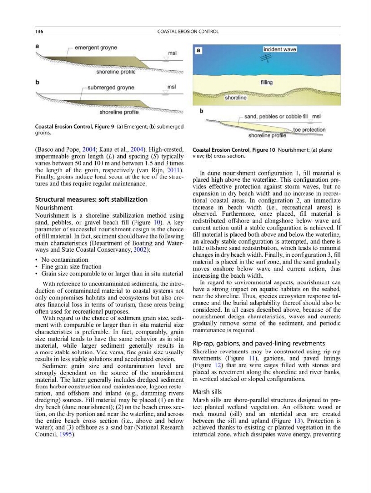
(Basco and Pope, 2004; Kana et al., 2004). High-crested,
impermeable groin length (L) and spacing (S) typically
varies between 50 and 100 m and between 1.5 and 3 times
the length of the groin, respectively (van Rijn, 2011).
Finally, groins induce local scour at the toe of the structures and thus require regular maintenance.
Structural measures: soft stabilization
Nourishment
Nourishment is a shoreline stabilization method using
sand, pebbles, or gravel beach fill (Figure 10). A key
parameter of successful nourishment design is the choice
of fill material. In fact, sediment should have the following
main characteristics (Department of Boating and Waterways and State Coastal Conservancy, 2002):
• No contamination
• Fine grain size fraction
• Grain size comparable to or larger than in situ material
With reference to uncontaminated sediments, the introduction of contaminated material to coastal systems not
only compromises habitats and ecosystems but also creates financial loss in terms of tourism, these areas being
often used for recreational purposes.
With regard to the choice of sediment grain size, sediment with comparable or larger than in situ material size
characteristics is preferable. In fact, comparably, grain
size material tends to have the same behavior as in situ
material, while larger sediment generally results in
a more stable solution. Vice versa, fine grain size usually
results in less stable solutions and accelerated erosion.
Sediment grain size and contamination level are
strongly dependant on the source of the nourishment
material. The latter generally includes dredged sediment
from harbor construction and maintenance, lagoon restoration, and offshore and inland (e.g., damming rivers
dredging) sources. Fill material may be placed (1) on the
dry beach (dune nourishment); (2) on the beach cross section, on the dry portion and near the waterline, and across
the entire beach cross section (i.e., above and below
water); and (3) offshore as a sand bar (National Research
Council, 1995).
In dune nourishment configuration 1, fill material is
placed high above the waterline. This configuration provides effective protection against storm waves, but no
expansion in dry beach width and no increase in recreational coastal areas. In configuration 2, an immediate
increase in beach width (i.e., recreational areas) is
observed. Furthermore, once placed, fill material is
redistributed offshore and alongshore below wave and
current action until a stable configuration is achieved. If
fill material is placed both above and below the waterline,
an already stable configuration is attempted, and there is
little offshore sand redistribution, which leads to minimal
changes in dry beach width. Finally, in configuration 3, fill
material is placed in the surf zone, and the sand gradually
moves onshore below wave and current action, thus
increasing the beach width.
In regard to environmental aspects, nourishment can
have a strong impact on aquatic habitats on the seabed,
near the shoreline. Thus, species ecosystem response tolerance and the burial adaptability thereof should also be
considered. In all cases described above, because of the
nourishment design characteristics, waves and currents
gradually remove some of the sediment, and periodic
maintenance is required.
Rip-rap, gabions, and paved-lining revetments
Shoreline revetments may be constructed using rip-rap
revetments (Figure 11), gabions, and paved linings
(Figure 12) that are wire cages filled with stones and
placed as revetment along the shoreline and river banks,
in vertical stacked or sloped configurations.
Marsh sills
Marsh sills are shore-parallel structures designed to protect planted wetland vegetation. An offshore wood or
rock mound (sill) and an intertidal area are created
between the sill and upland (Figure 13). Protection is
achieved thanks to existing or planted vegetation in the
intertidal zone, which dissipates wave energy, preventing
Coastal Erosion Control, Figure 9 (a) Emergent; (b) submerged
groins.
Coastal Erosion Control, Figure 10 Nourishment: (a) plane
view; (b) cross section.
136
COASTAL EROSION CONTROL
impermeable groin length (L) and spacing (S) typically
varies between 50 and 100 m and between 1.5 and 3 times
the length of the groin, respectively (van Rijn, 2011).
Finally, groins induce local scour at the toe of the structures and thus require regular maintenance.
Structural measures: soft stabilization
Nourishment
Nourishment is a shoreline stabilization method using
sand, pebbles, or gravel beach fill (Figure 10). A key
parameter of successful nourishment design is the choice
of fill material. In fact, sediment should have the following
main characteristics (Department of Boating and Waterways and State Coastal Conservancy, 2002):
• No contamination
• Fine grain size fraction
• Grain size comparable to or larger than in situ material
With reference to uncontaminated sediments, the introduction of contaminated material to coastal systems not
only compromises habitats and ecosystems but also creates financial loss in terms of tourism, these areas being
often used for recreational purposes.
With regard to the choice of sediment grain size, sediment with comparable or larger than in situ material size
characteristics is preferable. In fact, comparably, grain
size material tends to have the same behavior as in situ
material, while larger sediment generally results in
a more stable solution. Vice versa, fine grain size usually
results in less stable solutions and accelerated erosion.
Sediment grain size and contamination level are
strongly dependant on the source of the nourishment
material. The latter generally includes dredged sediment
from harbor construction and maintenance, lagoon restoration, and offshore and inland (e.g., damming rivers
dredging) sources. Fill material may be placed (1) on the
dry beach (dune nourishment); (2) on the beach cross section, on the dry portion and near the waterline, and across
the entire beach cross section (i.e., above and below
water); and (3) offshore as a sand bar (National Research
Council, 1995).
In dune nourishment configuration 1, fill material is
placed high above the waterline. This configuration provides effective protection against storm waves, but no
expansion in dry beach width and no increase in recreational coastal areas. In configuration 2, an immediate
increase in beach width (i.e., recreational areas) is
observed. Furthermore, once placed, fill material is
redistributed offshore and alongshore below wave and
current action until a stable configuration is achieved. If
fill material is placed both above and below the waterline,
an already stable configuration is attempted, and there is
little offshore sand redistribution, which leads to minimal
changes in dry beach width. Finally, in configuration 3, fill
material is placed in the surf zone, and the sand gradually
moves onshore below wave and current action, thus
increasing the beach width.
In regard to environmental aspects, nourishment can
have a strong impact on aquatic habitats on the seabed,
near the shoreline. Thus, species ecosystem response tolerance and the burial adaptability thereof should also be
considered. In all cases described above, because of the
nourishment design characteristics, waves and currents
gradually remove some of the sediment, and periodic
maintenance is required.
Rip-rap, gabions, and paved-lining revetments
Shoreline revetments may be constructed using rip-rap
revetments (Figure 11), gabions, and paved linings
(Figure 12) that are wire cages filled with stones and
placed as revetment along the shoreline and river banks,
in vertical stacked or sloped configurations.
Marsh sills
Marsh sills are shore-parallel structures designed to protect planted wetland vegetation. An offshore wood or
rock mound (sill) and an intertidal area are created
between the sill and upland (Figure 13). Protection is
achieved thanks to existing or planted vegetation in the
intertidal zone, which dissipates wave energy, preventing
Coastal Erosion Control, Figure 9 (a) Emergent; (b) submerged
groins.
Coastal Erosion Control, Figure 10 Nourishment: (a) plane
view; (b) cross section.
136
COASTAL EROSION CONTROL