

The Geomagnetic Field and its Role in Directional Orientation
291
curve around the earth and reenter its surface at the arctic pole. This means that
the magnetic vector points upwards in the Southern and downwards in the
Northern Hemisphere, being parallel to the earth's surface at the magnetic equator
(Fig. l ). The angle between the magnetic vector and the horizon is called
inclination or dip.
In most parts of the world, the field lines run roughly south-north. Yet magnetic
north and geographic north do not always coincide. The angular difference,
termed declination or variation, is considerable near the magnetic poles, but it
decreases rapidly towards lower latitudes. The total intensity of the field decreases
gradually from maximum values of about 60 000 nT at the poles to 30 000 nT near
the magnetic equator. A number of spatial and temporal irregularities are
superimposed on the general pattern described above. Yet these variations are
generally too small to interfere with the animals' magnetic compass.
1.2 Demonstrating Magnetic Compass Orientation
To show that a species uses the magnetic field as a compass for determining
directions, mere disorientation in the absence of suitable magnetic information is
not sufficient. It must be demonstrated that the directional tendencies of the
animals in question truly depend on the direction of the ambient magnetic field.
Magnetic compass orientation can only be accepted when a deflection of magnetic
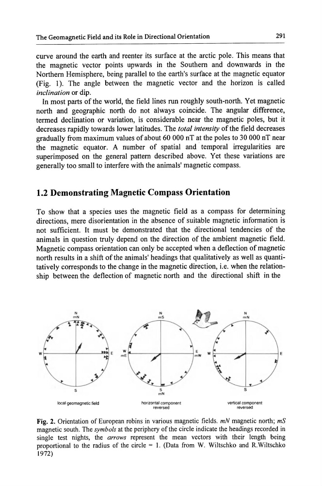
north results in a shift of the animals' headings that qualitatively as well as quantitatively corresponds to the change in the magnetic direction, i.e. when the relationship between the deflection of magnetic north and the directional shift in the
N
mN
s
local geomagnetic field
N
mS
s
mN
horizontal component
reversed
N
m N
s
vertical component
reversed
Fig. 2. Orientation of European robins in various magnetic fields. mN magnetic north; mS
magnetic south. The symbols at the periphery of the circle indicate the headings recorded in
single test nights, the arrows represent the mean vectors with their length being
proportional to the radius of the circle = I. (Data from W. Wiltschko and R.Wiltschko
1972)
291
curve around the earth and reenter its surface at the arctic pole. This means that
the magnetic vector points upwards in the Southern and downwards in the
Northern Hemisphere, being parallel to the earth's surface at the magnetic equator
(Fig. l ). The angle between the magnetic vector and the horizon is called
inclination or dip.
In most parts of the world, the field lines run roughly south-north. Yet magnetic
north and geographic north do not always coincide. The angular difference,
termed declination or variation, is considerable near the magnetic poles, but it
decreases rapidly towards lower latitudes. The total intensity of the field decreases
gradually from maximum values of about 60 000 nT at the poles to 30 000 nT near
the magnetic equator. A number of spatial and temporal irregularities are
superimposed on the general pattern described above. Yet these variations are
generally too small to interfere with the animals' magnetic compass.
1.2 Demonstrating Magnetic Compass Orientation
To show that a species uses the magnetic field as a compass for determining
directions, mere disorientation in the absence of suitable magnetic information is
not sufficient. It must be demonstrated that the directional tendencies of the
animals in question truly depend on the direction of the ambient magnetic field.
Magnetic compass orientation can only be accepted when a deflection of magnetic
north results in a shift of the animals' headings that qualitatively as well as quantitatively corresponds to the change in the magnetic direction, i.e. when the relationship between the deflection of magnetic north and the directional shift in the
N
mN
s
local geomagnetic field
N
mS
s
mN
horizontal component
reversed
N
m N
s
vertical component
reversed
Fig. 2. Orientation of European robins in various magnetic fields. mN magnetic north; mS
magnetic south. The symbols at the periphery of the circle indicate the headings recorded in
single test nights, the arrows represent the mean vectors with their length being
proportional to the radius of the circle = I. (Data from W. Wiltschko and R.Wiltschko
1972)