

637
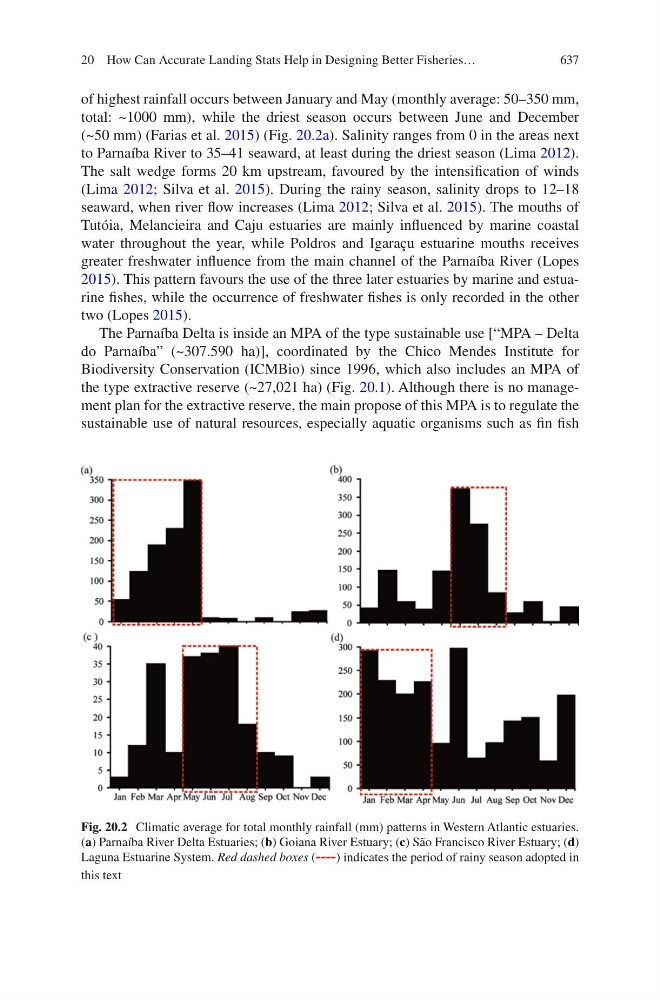
of highest rainfall occurs between January and May (monthly average: 50–350 mm,
total: ~1000 mm), while the driest season occurs between June and December
(~50 mm) (Farias et al. 2015) (Fig. 20.2a). Salinity ranges from 0 in the areas next
to Parnaíba River to 35–41 seaward, at least during the driest season (Lima 2012).
The salt wedge forms 20 km upstream, favoured by the intensification of winds
(Lima 2012; Silva et al. 2015). During the rainy season, salinity drops to 12–18
seaward, when river flow increases (Lima 2012; Silva et al. 2015). The mouths of
Tutóia, Melancieira and Caju estuaries are mainly influenced by marine coastal
water throughout the year, while Poldros and Igaraçu estuarine mouths receives
greater freshwater influence from the main channel of the Parnaíba River (Lopes
2015). This pattern favours the use of the three later estuaries by marine and estuarine fishes, while the occurrence of freshwater fishes is only recorded in the other
two (Lopes 2015).
The Parnaíba Delta is inside an MPA of the type sustainable use [“MPA – Delta
do Parnaíba” (~307.590 ha)], coordinated by the Chico Mendes Institute for
Biodiversity Conservation (ICMBio) since 1996, which also includes an MPA of
the type extractive reserve (~27,021 ha) (Fig. 20.1). Although there is no management plan for the extractive reserve, the main propose of this MPA is to regulate the
sustainable use of natural resources, especially aquatic organisms such as fin fish
Fig. 20.2 Climatic average for total monthly rainfall (mm) patterns in Western Atlantic estuaries.
(a) Parnaíba River Delta Estuaries; (b) Goiana River Estuary; (c) São Francisco River Estuary; (d)
Laguna Estuarine System. Red dashed boxes (----) indicates the period of rainy season adopted in
this text
20 How Can Accurate Landing Stats Help in Designing Better Fisheries…