

333
The southern (Forster) jetty was constructed in 1898. While it improved the tidal
conveyance somewhat, often entrance navigability was compromised still so, in
1966, the southern jetty was extended some 90 m and a 460 m long jetty was constructed on the northern (Tuncurry) side.
Dramatic changes to the Wallis Lake estuary ensued. These were attributed to the
increased hydraulic conveyance of the inlet occasioned by the construction of the
northern jetty (Nielsen and Gordon 1980). Since 1990, when consistent and reliable
data became available, the bay’s spring tidal range, as measured at Tiona (Fig. 10.12),
has continued to increase at a rate of 1.8 mm/a (R
2
= 0.89) and, by the year 2015, the
ratio of the bay range to that of the ocean had risen from 0.09 to 0.14, a 55% increase,
at a rate of 0.0016/a (R
2
= 0.92) and showing little signs of abating (Fig. 10.14).
The history of the major spring tidal constituent (M2) phase lag (bay phase minus
ocean phase) from 1990, presented in Fig. 10.15, shows a weak decreasing trend
indicating increasing efficiency in tidal wave penetration of the estuary.
An Escoffier Diagram (Fig. 10.16) was constructed for Wallis Lake following the
method of Czerniak (1978), assuming the most constricted width of the inlet channel (Seabergh and Kraus 1997) of 100 m at the entrance with a channel depth of
5 m. This gave an effective friction length for the channel of 3,400 m. It was assumed
also that the tidal discharge curve was sinusoidal with period 12.4 h to enable the
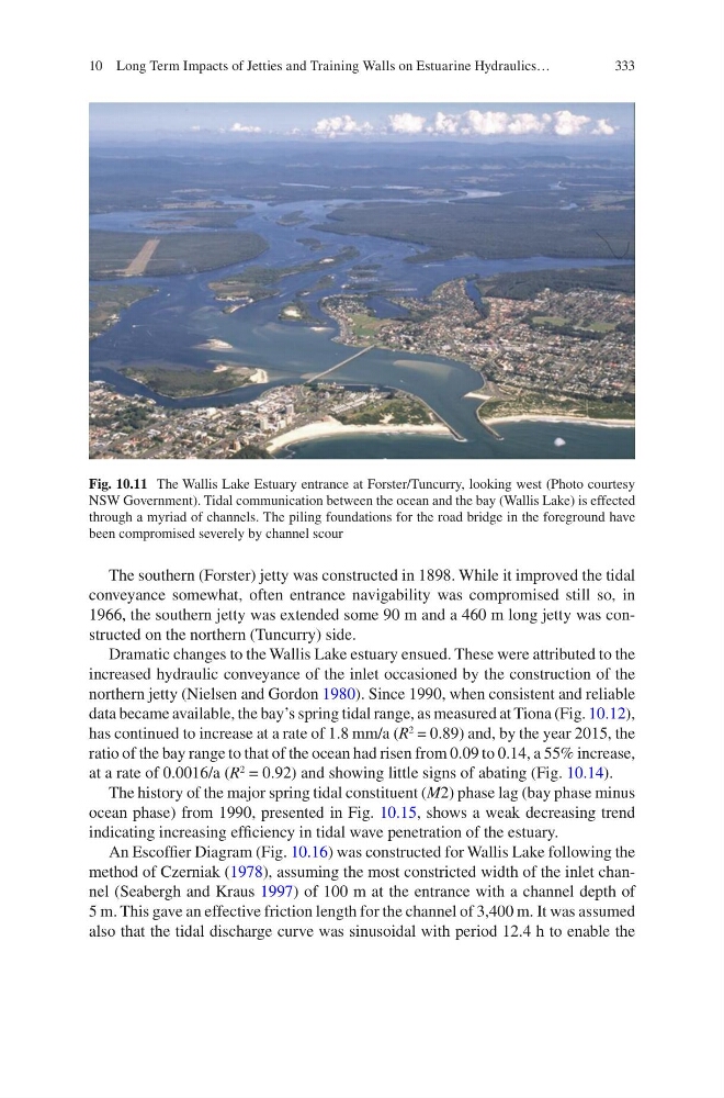
Fig. 10.11 The Wallis Lake Estuary entrance at Forster/Tuncurry, looking west (Photo courtesy
NSW Government). Tidal communication between the ocean and the bay (Wallis Lake) is effected
through a myriad of channels. The piling foundations for the road bridge in the foreground have
been compromised severely by channel scour
10 Long Term Impacts of Jetties and Training Walls on Estuarine Hydraulics…
The southern (Forster) jetty was constructed in 1898. While it improved the tidal
conveyance somewhat, often entrance navigability was compromised still so, in
1966, the southern jetty was extended some 90 m and a 460 m long jetty was constructed on the northern (Tuncurry) side.
Dramatic changes to the Wallis Lake estuary ensued. These were attributed to the
increased hydraulic conveyance of the inlet occasioned by the construction of the
northern jetty (Nielsen and Gordon 1980). Since 1990, when consistent and reliable
data became available, the bay’s spring tidal range, as measured at Tiona (Fig. 10.12),
has continued to increase at a rate of 1.8 mm/a (R
2
= 0.89) and, by the year 2015, the
ratio of the bay range to that of the ocean had risen from 0.09 to 0.14, a 55% increase,
at a rate of 0.0016/a (R
2
= 0.92) and showing little signs of abating (Fig. 10.14).
The history of the major spring tidal constituent (M2) phase lag (bay phase minus
ocean phase) from 1990, presented in Fig. 10.15, shows a weak decreasing trend
indicating increasing efficiency in tidal wave penetration of the estuary.
An Escoffier Diagram (Fig. 10.16) was constructed for Wallis Lake following the
method of Czerniak (1978), assuming the most constricted width of the inlet channel (Seabergh and Kraus 1997) of 100 m at the entrance with a channel depth of
5 m. This gave an effective friction length for the channel of 3,400 m. It was assumed
also that the tidal discharge curve was sinusoidal with period 12.4 h to enable the
Fig. 10.11 The Wallis Lake Estuary entrance at Forster/Tuncurry, looking west (Photo courtesy
NSW Government). Tidal communication between the ocean and the bay (Wallis Lake) is effected
through a myriad of channels. The piling foundations for the road bridge in the foreground have
been compromised severely by channel scour
10 Long Term Impacts of Jetties and Training Walls on Estuarine Hydraulics…