

332
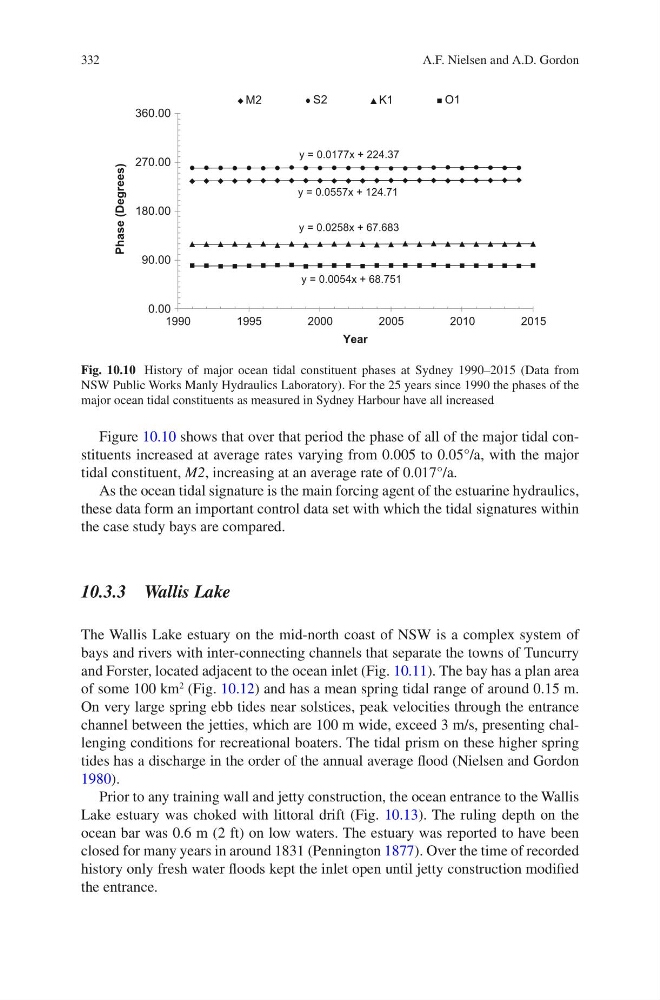
Figure 10.10 shows that over that period the phase of all of the major tidal constituents increased at average rates varying from 0.005 to 0.05°/a, with the major
tidal constituent, M2, increasing at an average rate of 0.017°/a.
As the ocean tidal signature is the main forcing agent of the estuarine hydraulics,
these data form an important control data set with which the tidal signatures within
the case study bays are compared.
10.3.3 Wallis Lake
The Wallis Lake estuary on the mid-north coast of NSW is a complex system of
bays and rivers with inter-connecting channels that separate the towns of Tuncurry
and Forster, located adjacent to the ocean inlet (Fig. 10.11). The bay has a plan area
of some 100 km
2
(Fig. 10.12) and has a mean spring tidal range of around 0.15 m.
On very large spring ebb tides near solstices, peak velocities through the entrance
channel between the jetties, which are 100 m wide, exceed 3 m/s, presenting challenging conditions for recreational boaters. The tidal prism on these higher spring
tides has a discharge in the order of the annual average flood (Nielsen and Gordon
1980).
Prior to any training wall and jetty construction, the ocean entrance to the Wallis
Lake estuary was choked with littoral drift (Fig. 10.13). The ruling depth on the
ocean bar was 0.6 m (2 ft) on low waters. The estuary was reported to have been
closed for many years in around 1831 (Pennington 1877). Over the time of recorded
history only fresh water floods kept the inlet open until jetty construction modified
the entrance.
y = 0.0557x + 124.71
y = 0.0177x + 224.37
y = 0.0258x + 67.683
y = 0.0054x + 68.751
0.00
90.00
180.00
270.00
360.00
1990
1995
2000
2005
2010
2015
Phase (Degrees)
Year
M2
S2
K1
O1
Fig. 10.10 History of major ocean tidal constituent phases at Sydney 1990–2015 (Data from
NSW Public Works Manly Hydraulics Laboratory). For the 25 years since 1990 the phases of the
major ocean tidal constituents as measured in Sydney Harbour have all increased
A.F. Nielsen and A.D. Gordon
Figure 10.10 shows that over that period the phase of all of the major tidal constituents increased at average rates varying from 0.005 to 0.05°/a, with the major
tidal constituent, M2, increasing at an average rate of 0.017°/a.
As the ocean tidal signature is the main forcing agent of the estuarine hydraulics,
these data form an important control data set with which the tidal signatures within
the case study bays are compared.
10.3.3 Wallis Lake
The Wallis Lake estuary on the mid-north coast of NSW is a complex system of
bays and rivers with inter-connecting channels that separate the towns of Tuncurry
and Forster, located adjacent to the ocean inlet (Fig. 10.11). The bay has a plan area
of some 100 km
2
(Fig. 10.12) and has a mean spring tidal range of around 0.15 m.
On very large spring ebb tides near solstices, peak velocities through the entrance
channel between the jetties, which are 100 m wide, exceed 3 m/s, presenting challenging conditions for recreational boaters. The tidal prism on these higher spring
tides has a discharge in the order of the annual average flood (Nielsen and Gordon
1980).
Prior to any training wall and jetty construction, the ocean entrance to the Wallis
Lake estuary was choked with littoral drift (Fig. 10.13). The ruling depth on the
ocean bar was 0.6 m (2 ft) on low waters. The estuary was reported to have been
closed for many years in around 1831 (Pennington 1877). Over the time of recorded
history only fresh water floods kept the inlet open until jetty construction modified
the entrance.
y = 0.0557x + 124.71
y = 0.0177x + 224.37
y = 0.0258x + 67.683
y = 0.0054x + 68.751
0.00
90.00
180.00
270.00
360.00
1990
1995
2000
2005
2010
2015
Phase (Degrees)
Year
M2
S2
K1
O1
Fig. 10.10 History of major ocean tidal constituent phases at Sydney 1990–2015 (Data from
NSW Public Works Manly Hydraulics Laboratory). For the 25 years since 1990 the phases of the
major ocean tidal constituents as measured in Sydney Harbour have all increased
A.F. Nielsen and A.D. Gordon