

150
flow faster because of the concrete river bed (Robertson and Alongi 1992; Islam et al.
2014). Mangrove swamps survive with saline water (Stewart 1986a, b). If the amount
of water is domineering at the mangrove area, the saline water will receive more freshwater resulting the destruction of the mangrove area (Robertson and Alongi 1992).
As this process goes on, there will be lesser mangrove forest. Part of the Mangrove
forest characteristics is to infiltrate water and also help to slow down the impact of
incoming water. However, with the degrading of mangrove forest through time, the
flow of water will be much faster and the meandering river will be cut through (Islam
et al. 2014). The meandering cut through could also cause by natural causes such as
heavy rainfall that result in high storm. High storm can trigger fast flowing water
and rough river channel that could affect the river environment (US EPA 2008;
Wolanski et al. 2009; Woodroffe and Davies 2009).
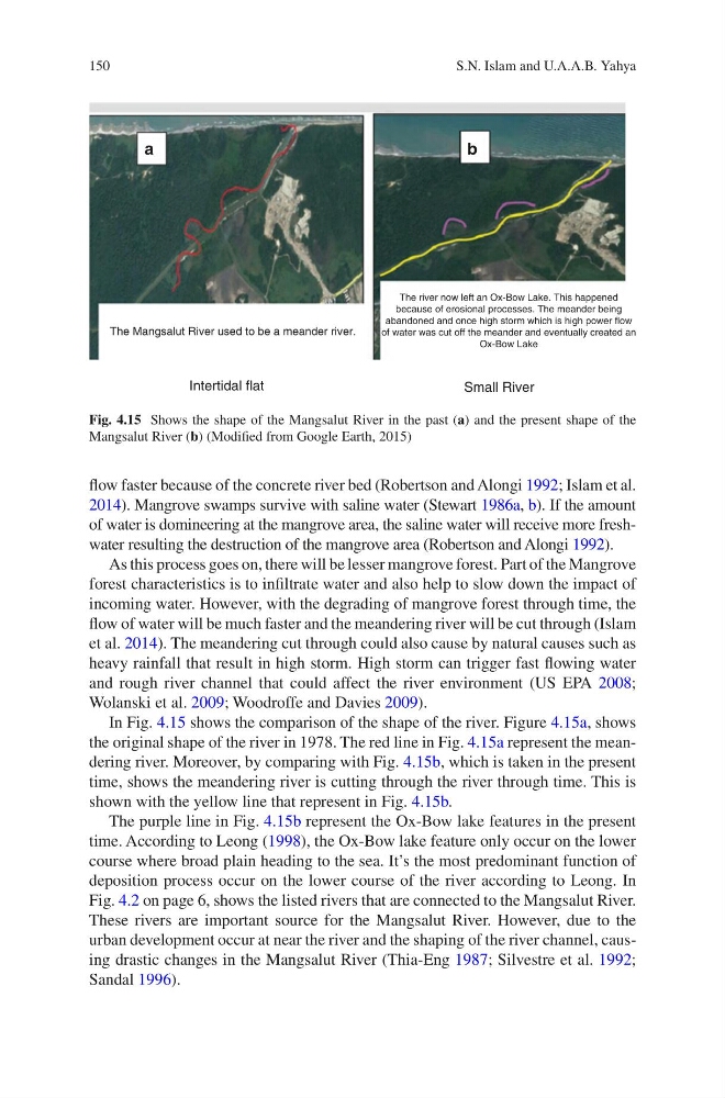
In Fig. 4.15 shows the comparison of the shape of the river. Figure 4.15a, shows
the original shape of the river in 1978. The red line in Fig. 4.15a represent the meandering river. Moreover, by comparing with Fig. 4.15b, which is taken in the present
time, shows the meandering river is cutting through the river through time. This is
shown with the yellow line that represent in Fig. 4.15b.
The purple line in Fig. 4.15b represent the Ox-Bow lake features in the present
time. According to Leong (1998), the Ox-Bow lake feature only occur on the lower
course where broad plain heading to the sea. It’s the most predominant function of
deposition process occur on the lower course of the river according to Leong. In
Fig. 4.2 on page 6, shows the listed rivers that are connected to the Mangsalut River.
These rivers are important source for the Mangsalut River. However, due to the
urban development occur at near the river and the shaping of the river channel, causing drastic changes in the Mangsalut River (Thia-Eng 1987; Silvestre et al. 1992;
Sandal 1996).
The Mangsalut River used to be a meander river.
The river now left an Ox-Bow Lake. This happened
because of erosional processes. The meander being
abandoned and once high storm which is high power flow
of water was cut off the meander and eventually created an
Ox-Bow Lake
Intertidal flat
Small River
a
b
Fig. 4.15 Shows the shape of the Mangsalut River in the past (a) and the present shape of the
Mangsalut River (b) (Modified from Google Earth, 2015)
S.N. Islam and U.A.A.B. Yahya
flow faster because of the concrete river bed (Robertson and Alongi 1992; Islam et al.
2014). Mangrove swamps survive with saline water (Stewart 1986a, b). If the amount
of water is domineering at the mangrove area, the saline water will receive more freshwater resulting the destruction of the mangrove area (Robertson and Alongi 1992).
As this process goes on, there will be lesser mangrove forest. Part of the Mangrove
forest characteristics is to infiltrate water and also help to slow down the impact of
incoming water. However, with the degrading of mangrove forest through time, the
flow of water will be much faster and the meandering river will be cut through (Islam
et al. 2014). The meandering cut through could also cause by natural causes such as
heavy rainfall that result in high storm. High storm can trigger fast flowing water
and rough river channel that could affect the river environment (US EPA 2008;
Wolanski et al. 2009; Woodroffe and Davies 2009).
In Fig. 4.15 shows the comparison of the shape of the river. Figure 4.15a, shows
the original shape of the river in 1978. The red line in Fig. 4.15a represent the meandering river. Moreover, by comparing with Fig. 4.15b, which is taken in the present
time, shows the meandering river is cutting through the river through time. This is
shown with the yellow line that represent in Fig. 4.15b.
The purple line in Fig. 4.15b represent the Ox-Bow lake features in the present
time. According to Leong (1998), the Ox-Bow lake feature only occur on the lower
course where broad plain heading to the sea. It’s the most predominant function of
deposition process occur on the lower course of the river according to Leong. In
Fig. 4.2 on page 6, shows the listed rivers that are connected to the Mangsalut River.
These rivers are important source for the Mangsalut River. However, due to the
urban development occur at near the river and the shaping of the river channel, causing drastic changes in the Mangsalut River (Thia-Eng 1987; Silvestre et al. 1992;
Sandal 1996).
The Mangsalut River used to be a meander river.
The river now left an Ox-Bow Lake. This happened
because of erosional processes. The meander being
abandoned and once high storm which is high power flow
of water was cut off the meander and eventually created an
Ox-Bow Lake
Intertidal flat
Small River
a
b
Fig. 4.15 Shows the shape of the Mangsalut River in the past (a) and the present shape of the
Mangsalut River (b) (Modified from Google Earth, 2015)
S.N. Islam and U.A.A.B. Yahya