

149
the area itself. The only feature present was the Nipa Trees (Nipa frutican), Swamp,
Peat Swamp Forest, Intertidal flat and Small River (Christensen 1984) (Fig. 4.13).
By referring to Fig. 4.13, there is no sighting of the Mangrove Forest surrounds
the Mangsalut Area. Only Nipa Trees that conquer the area of Mangsalut River and
some patches of swampy area. This is because by the development that is occurring
surrounds the area of the Mangsalut River (Silvestre et al. 1992). The development is
overbearing in the present time compare with the era in 1978. The land clearance for
major highway, housing scheme and buildings followed by heavy construction activities that is sited east side beside the Mangsalut River (Roger M and John EE 2009).
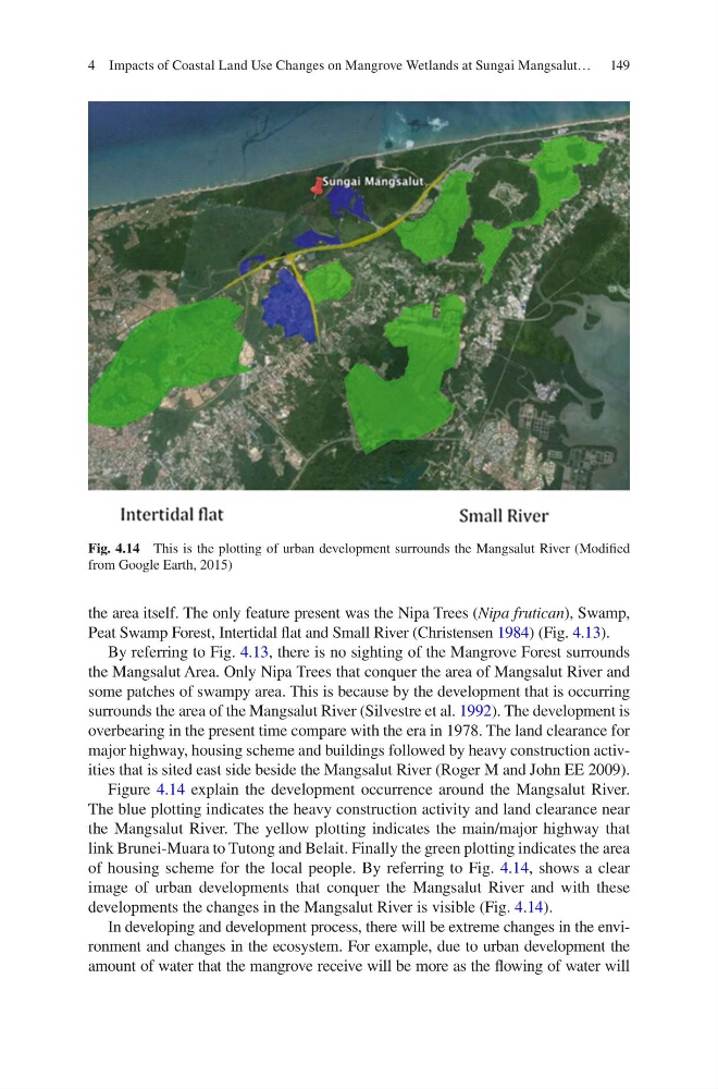
Figure 4.14 explain the development occurrence around the Mangsalut River.
The blue plotting indicates the heavy construction activity and land clearance near
the Mangsalut River. The yellow plotting indicates the main/major highway that
link Brunei-Muara to Tutong and Belait. Finally the green plotting indicates the area
of housing scheme for the local people. By referring to Fig. 4.14, shows a clear
image of urban developments that conquer the Mangsalut River and with these
developments the changes in the Mangsalut River is visible (Fig. 4.14).
In developing and development process, there will be extreme changes in the environment and changes in the ecosystem. For example, due to urban development the
amount of water that the mangrove receive will be more as the flowing of water will
Fig. 4.14 This is the plotting of urban development surrounds the Mangsalut River (Modified
from Google Earth, 2015)
4 Impacts of Coastal Land Use Changes on Mangrove Wetlands at Sungai Mangsalut…
the area itself. The only feature present was the Nipa Trees (Nipa frutican), Swamp,
Peat Swamp Forest, Intertidal flat and Small River (Christensen 1984) (Fig. 4.13).
By referring to Fig. 4.13, there is no sighting of the Mangrove Forest surrounds
the Mangsalut Area. Only Nipa Trees that conquer the area of Mangsalut River and
some patches of swampy area. This is because by the development that is occurring
surrounds the area of the Mangsalut River (Silvestre et al. 1992). The development is
overbearing in the present time compare with the era in 1978. The land clearance for
major highway, housing scheme and buildings followed by heavy construction activities that is sited east side beside the Mangsalut River (Roger M and John EE 2009).
Figure 4.14 explain the development occurrence around the Mangsalut River.
The blue plotting indicates the heavy construction activity and land clearance near
the Mangsalut River. The yellow plotting indicates the main/major highway that
link Brunei-Muara to Tutong and Belait. Finally the green plotting indicates the area
of housing scheme for the local people. By referring to Fig. 4.14, shows a clear
image of urban developments that conquer the Mangsalut River and with these
developments the changes in the Mangsalut River is visible (Fig. 4.14).
In developing and development process, there will be extreme changes in the environment and changes in the ecosystem. For example, due to urban development the
amount of water that the mangrove receive will be more as the flowing of water will
Fig. 4.14 This is the plotting of urban development surrounds the Mangsalut River (Modified
from Google Earth, 2015)
4 Impacts of Coastal Land Use Changes on Mangrove Wetlands at Sungai Mangsalut…