

142
from inland and flow towards the Mangsalut River, however the mouth of the river
mangsalut also receiving the tidal saltwater coming from the sea. These water will meet
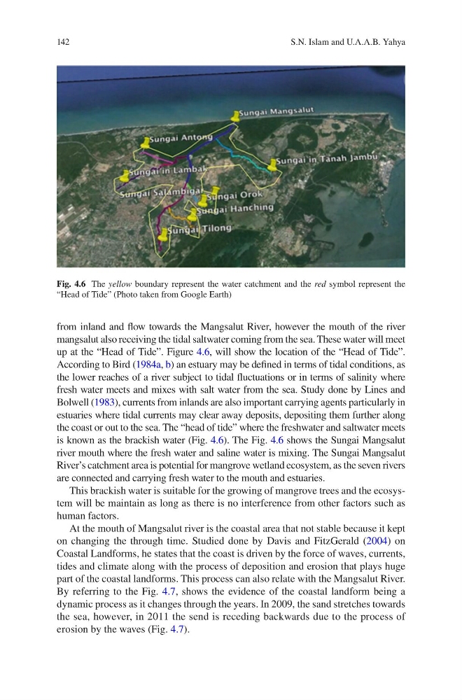
up at the “Head of Tide”. Figure 4.6, will show the location of the “Head of Tide”.
According to Bird (1984a, b) an estuary may be defined in terms of tidal conditions, as
the lower reaches of a river subject to tidal fluctuations or in terms of salinity where
fresh water meets and mixes with salt water from the sea. Study done by Lines and
Bolwell (1983), currents from inlands are also important carrying agents particularly in
estuaries where tidal currents may clear away deposits, depositing them further along
the coast or out to the sea. The “head of tide” where the freshwater and saltwater meets
is known as the brackish water (Fig. 4.6). The Fig. 4.6 shows the Sungai Mangsalut
river mouth where the fresh water and saline water is mixing. The Sungai Mangsalut
River’s catchment area is potential for mangrove wetland ecosystem, as the seven rivers
are connected and carrying fresh water to the mouth and estuaries.
This brackish water is suitable for the growing of mangrove trees and the ecosystem will be maintain as long as there is no interference from other factors such as
human factors.
At the mouth of Mangsalut river is the coastal area that not stable because it kept
on changing the through time. Studied done by Davis and FitzGerald (2004) on
Coastal Landforms, he states that the coast is driven by the force of waves, currents,
tides and climate along with the process of deposition and erosion that plays huge
part of the coastal landforms. This process can also relate with the Mangsalut River.
By referring to the Fig. 4.7, shows the evidence of the coastal landform being a
dynamic process as it changes through the years. In 2009, the sand stretches towards
the sea, however, in 2011 the send is receding backwards due to the process of
erosion by the waves (Fig. 4.7).
Fig. 4.6 The yellow boundary represent the water catchment and the red symbol represent the
“Head of Tide” (Photo taken from Google Earth)
S.N. Islam and U.A.A.B. Yahya
from inland and flow towards the Mangsalut River, however the mouth of the river
mangsalut also receiving the tidal saltwater coming from the sea. These water will meet
up at the “Head of Tide”. Figure 4.6, will show the location of the “Head of Tide”.
According to Bird (1984a, b) an estuary may be defined in terms of tidal conditions, as
the lower reaches of a river subject to tidal fluctuations or in terms of salinity where
fresh water meets and mixes with salt water from the sea. Study done by Lines and
Bolwell (1983), currents from inlands are also important carrying agents particularly in
estuaries where tidal currents may clear away deposits, depositing them further along
the coast or out to the sea. The “head of tide” where the freshwater and saltwater meets
is known as the brackish water (Fig. 4.6). The Fig. 4.6 shows the Sungai Mangsalut
river mouth where the fresh water and saline water is mixing. The Sungai Mangsalut
River’s catchment area is potential for mangrove wetland ecosystem, as the seven rivers
are connected and carrying fresh water to the mouth and estuaries.
This brackish water is suitable for the growing of mangrove trees and the ecosystem will be maintain as long as there is no interference from other factors such as
human factors.
At the mouth of Mangsalut river is the coastal area that not stable because it kept
on changing the through time. Studied done by Davis and FitzGerald (2004) on
Coastal Landforms, he states that the coast is driven by the force of waves, currents,
tides and climate along with the process of deposition and erosion that plays huge
part of the coastal landforms. This process can also relate with the Mangsalut River.
By referring to the Fig. 4.7, shows the evidence of the coastal landform being a
dynamic process as it changes through the years. In 2009, the sand stretches towards
the sea, however, in 2011 the send is receding backwards due to the process of
erosion by the waves (Fig. 4.7).
Fig. 4.6 The yellow boundary represent the water catchment and the red symbol represent the
“Head of Tide” (Photo taken from Google Earth)
S.N. Islam and U.A.A.B. Yahya