

502
Asia
Latin America
Africa
North America
Nordic
Europe
Mediterranean
Oceania
World
United States
Basin
o
5
10
15
20
25
Hectares per person
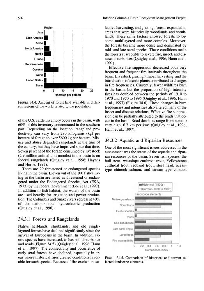
FIGURE 34.4. Amount of forest land available in different regions of the world related to the population.
of the U.S. cattle inventory occurs in the basin, with
60% of this inventory concentrated in the southern
part. Depending on the location, rangeland productivity can vary from 280 kilograms (kg) per
hectare of forage to over 5600 kg per hectare. Misuse and abuse degraded rangelands at the tum of
the century, but they have improved since that time.
Seven percent of the forage consumed by livestock
(2.9 million animal unit months) in the basin is on
federal rangelands (Quigley et aI., 1996; Haynes
and Home, 1997).
There are 29 threatened or endangered species
living in the basin. Eleven out of the 100 fishes living in the basin are listed as threatened or endangered under the Endangered Species Act (ESA,
1973) by the federal government (Lee et aI., 1997).
In addition to fish habitat, the waters of the basin
are used heavily for irrigation and power production. The Columbia and Snake rivers represent 40%
of the nation's total hydroelectric production
(Quigley et aI., 1996).
34.3.1 Forests and Rangelands
Native herblands, shrublands, and old singlelayered forests have declined significantly since the
arrival of Europeans in the basin. In addition, exotic species have increased, as has soil disturbance
and roads (Figure 34.5) (Quigley et aI., 1996; Hann
et aI., 1997). The connectivity and occurrence of
early seral forests have declined, especially in areas where historical fires created conditions favorable for such species. Because of fire exclusion, seInterior Columbia Basin Ecosystem Management Project
lective harvesting, and grazing, forests expanded in
areas that were historically woodlands and shrublands. These same factors allowed forests to become multilayered and more complex. Moreover,
the forests became more dense and dominated by
mid- and late-seral species. These conditions make
the forests susceptible to severe fire, insect, and disease disturbances (Quigley et aI., 1996; Hann et aI.,
1997).
Effective fire suppression decreased both very
frequent and frequent fire intervals throughout the
basin. Livestock grazing, timber harvesting, and the
introduction of exotic plants contributed to changes
in fire frequencies. Currently, fewer wildfires bum
in the basin, but the proportion of high-intensity
fires has doubled between the periods of 1910 to
1970 and 1970 to 1995 (Quigley et aI., 1996; Hann
et aI., 1997) (Figure 34.6). These changes in bum
frequencies and intensities also altered many of the
insect and disease relations. Effective fire suppression can be partially attributed to the roads that occur in the basin. Road densities range from none to
very high, 6.7 km per km 2 (Quigley et aI., 1996;
Hann et aI., 1997).
34.3.2 Aquatic and Riparian Resources
One of the most significant issues addressed in the
assessment was the status of the aquatic and riparian resources of the basin. Seven fish species, the
bull trout, westslope cutthroat trout, Yellowstone
cutthroat trout, redband trout, steel head, oceantype chinook salmon, and stream-type chinook
Native grasslands
Shrublands
Exotic species
Roads
Soil disturbance
Late sera I single
Large trees
Fire susceptibility
. Historical (1800s)
oCurrent (1970 to 1995)
Landscape elements
J
-
o 0.2 0.4 0.6 0 .8
1 .2
Comparison index
FIGURE 34.5. Comparison of historical and current selected landscape elements.
Asia
Latin America
Africa
North America
Nordic
Europe
Mediterranean
Oceania
World
United States
Basin
o
5
10
15
20
25
Hectares per person
FIGURE 34.4. Amount of forest land available in different regions of the world related to the population.
of the U.S. cattle inventory occurs in the basin, with
60% of this inventory concentrated in the southern
part. Depending on the location, rangeland productivity can vary from 280 kilograms (kg) per
hectare of forage to over 5600 kg per hectare. Misuse and abuse degraded rangelands at the tum of
the century, but they have improved since that time.
Seven percent of the forage consumed by livestock
(2.9 million animal unit months) in the basin is on
federal rangelands (Quigley et aI., 1996; Haynes
and Home, 1997).
There are 29 threatened or endangered species
living in the basin. Eleven out of the 100 fishes living in the basin are listed as threatened or endangered under the Endangered Species Act (ESA,
1973) by the federal government (Lee et aI., 1997).
In addition to fish habitat, the waters of the basin
are used heavily for irrigation and power production. The Columbia and Snake rivers represent 40%
of the nation's total hydroelectric production
(Quigley et aI., 1996).
34.3.1 Forests and Rangelands
Native herblands, shrublands, and old singlelayered forests have declined significantly since the
arrival of Europeans in the basin. In addition, exotic species have increased, as has soil disturbance
and roads (Figure 34.5) (Quigley et aI., 1996; Hann
et aI., 1997). The connectivity and occurrence of
early seral forests have declined, especially in areas where historical fires created conditions favorable for such species. Because of fire exclusion, seInterior Columbia Basin Ecosystem Management Project
lective harvesting, and grazing, forests expanded in
areas that were historically woodlands and shrublands. These same factors allowed forests to become multilayered and more complex. Moreover,
the forests became more dense and dominated by
mid- and late-seral species. These conditions make
the forests susceptible to severe fire, insect, and disease disturbances (Quigley et aI., 1996; Hann et aI.,
1997).
Effective fire suppression decreased both very
frequent and frequent fire intervals throughout the
basin. Livestock grazing, timber harvesting, and the
introduction of exotic plants contributed to changes
in fire frequencies. Currently, fewer wildfires bum
in the basin, but the proportion of high-intensity
fires has doubled between the periods of 1910 to
1970 and 1970 to 1995 (Quigley et aI., 1996; Hann
et aI., 1997) (Figure 34.6). These changes in bum
frequencies and intensities also altered many of the
insect and disease relations. Effective fire suppression can be partially attributed to the roads that occur in the basin. Road densities range from none to
very high, 6.7 km per km 2 (Quigley et aI., 1996;
Hann et aI., 1997).
34.3.2 Aquatic and Riparian Resources
One of the most significant issues addressed in the
assessment was the status of the aquatic and riparian resources of the basin. Seven fish species, the
bull trout, westslope cutthroat trout, Yellowstone
cutthroat trout, redband trout, steel head, oceantype chinook salmon, and stream-type chinook
Native grasslands
Shrublands
Exotic species
Roads
Soil disturbance
Late sera I single
Large trees
Fire susceptibility
. Historical (1800s)
oCurrent (1970 to 1995)
Landscape elements
J
-
o 0.2 0.4 0.6 0 .8
1 .2
Comparison index
FIGURE 34.5. Comparison of historical and current selected landscape elements.