

410
Characterizing the Human Imprint on Landscapes for Ecological Assessment
State
D County
D MCD
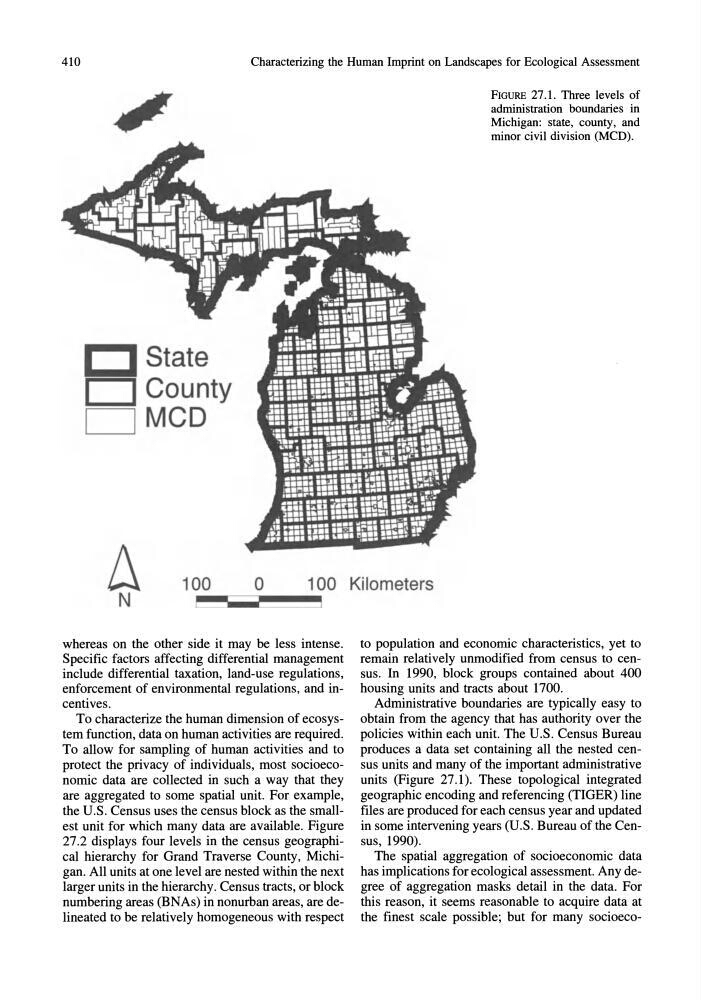
FIGURE 27.1. Three levels of
administration boundaries in
Michigan: state, county, and
minor civil division (MCD).
~ 100 o 100 Kilometers
N
whereas on the other side it may be less intense.
Specific factors affecting differential management
include differential taxation, land-use regulations,
enforcement of environmental regulations, and incentives.
To characterize the human dimension of ecosystem function, data on human activities are required.
To allow for sampling of human activities and to
protect the privacy of individuals, most socioeconomic data are collected in such a way that they
are aggregated to some spatial unit. For example,
the U.S. Census uses the census block as the smallest unit for which many data are available. Figure
27.2 displays four levels in the census geographical hierarchy for Grand Traverse County, Michigan. All units at one level are nested within the next
larger units in the hierarchy. Census tracts, or block
numbering areas (BNAs) in nonurban areas, are delineated to be relatively homogeneous with respect
to population and economic characteristics, yet to
remain relatively unmodified from census to census. In 1990, block groups contained about 400
housing units and tracts about 1700.
Administrative boundaries are typically easy to
obtain from the agency that has authority over the
policies within each unit. The U.S. Census Bureau
produces a data set containing all the nested census units and many of the important administrative
units (Figure 27.1). These topological integrated
geographic encoding and referencing (TIGER) line
files are produced for each census year and updated
in some intervening years (U.S. Bureau of the Census, 1990).
The spatial aggregation of socioeconomic data
has implications for ecological assessment. Any degree of aggregation masks detail in the data. For
this reason, it seems reasonable to acquire data at
the finest scale possible; but for many socioeco-
Characterizing the Human Imprint on Landscapes for Ecological Assessment
State
D County
D MCD
FIGURE 27.1. Three levels of
administration boundaries in
Michigan: state, county, and
minor civil division (MCD).
~ 100 o 100 Kilometers
N
whereas on the other side it may be less intense.
Specific factors affecting differential management
include differential taxation, land-use regulations,
enforcement of environmental regulations, and incentives.
To characterize the human dimension of ecosystem function, data on human activities are required.
To allow for sampling of human activities and to
protect the privacy of individuals, most socioeconomic data are collected in such a way that they
are aggregated to some spatial unit. For example,
the U.S. Census uses the census block as the smallest unit for which many data are available. Figure
27.2 displays four levels in the census geographical hierarchy for Grand Traverse County, Michigan. All units at one level are nested within the next
larger units in the hierarchy. Census tracts, or block
numbering areas (BNAs) in nonurban areas, are delineated to be relatively homogeneous with respect
to population and economic characteristics, yet to
remain relatively unmodified from census to census. In 1990, block groups contained about 400
housing units and tracts about 1700.
Administrative boundaries are typically easy to
obtain from the agency that has authority over the
policies within each unit. The U.S. Census Bureau
produces a data set containing all the nested census units and many of the important administrative
units (Figure 27.1). These topological integrated
geographic encoding and referencing (TIGER) line
files are produced for each census year and updated
in some intervening years (U.S. Bureau of the Census, 1990).
The spatial aggregation of socioeconomic data
has implications for ecological assessment. Any degree of aggregation masks detail in the data. For
this reason, it seems reasonable to acquire data at
the finest scale possible; but for many socioeco-